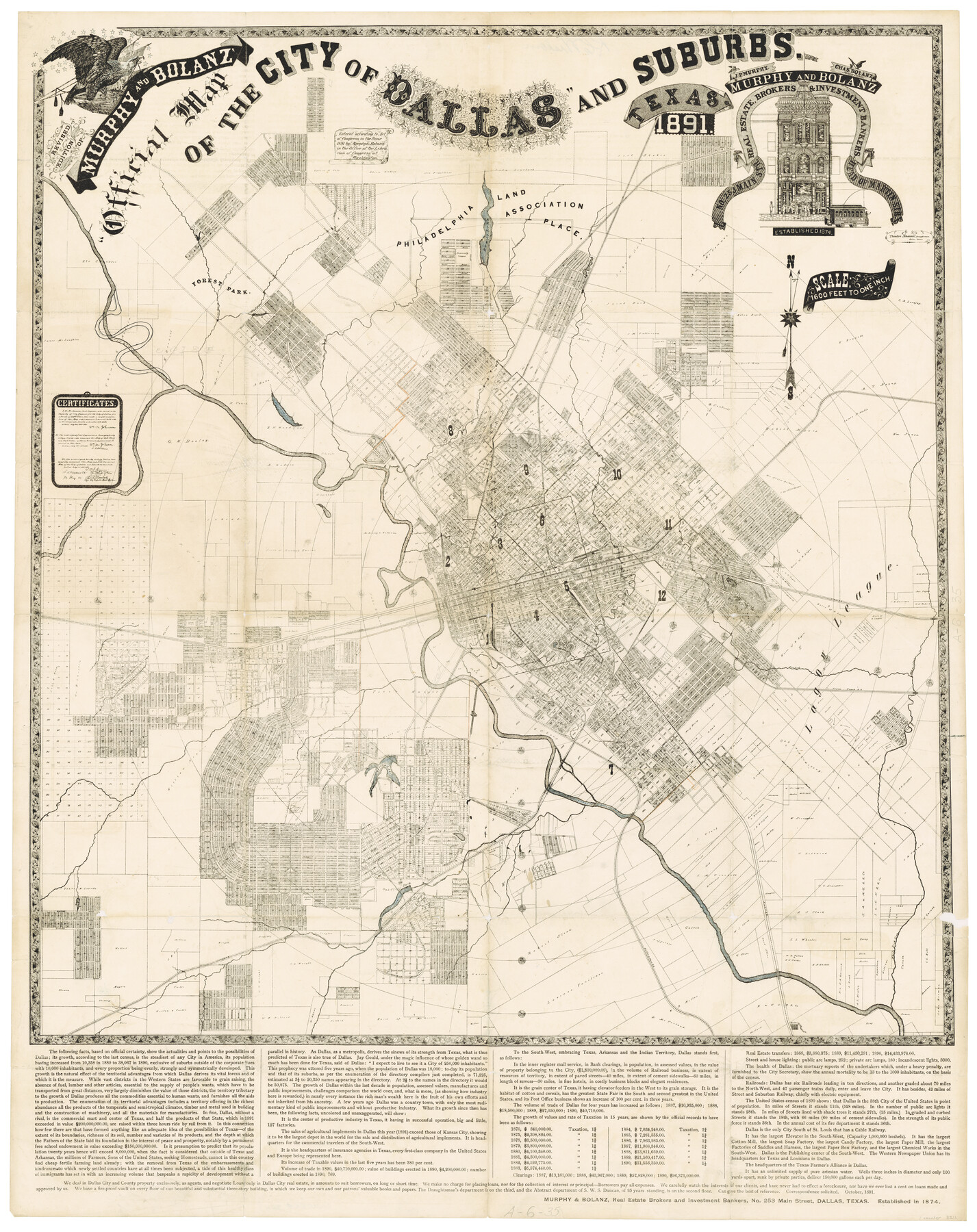
Official Map of the City of Dallas and Suburbs
A-6-35
-
Map/Doc
3211
-
Collection
General Map Collection
-
Object Dates
1891 (Creation Date)
-
People and Organizations
Murphy and Bolanz (Publisher)
Theodore Schauseil (Draftsman)
-
Counties
Dallas
-
Subjects
City
-
Height x Width
37.8 x 30.1 inches
96.0 x 76.5 cm
-
Medium
paper, etching/engraving/lithograph
-
Scale
1" = 1600 ft.
-
Comments
Conservation funded in 2002 with donation from John Martin Davis, Junior. Revised edition.
-
Features
T&P
Orphan's Home
Masonic Cemetery
Wallace Branch [of Mill Creek]
Westbrook Branch [of Turtle Creek]
Esall Lake
Miller's Station
GC&SF
D&W
Oak Cliff Park
Cedar Creek
Peak Creek
TTRR
White Rock Creek
MK&T
Texas State Fair and Dallas Exposition Grounds
West Fork of Trinity River
Trinity River
Spring Lake
Colored Cemetery
GC&SF
Episcopal College
Turtle Creek
Cedar Creek
Elm Fork [of Trinity River]
Knights Branch [of Trinity River]
Noble Branch [of Trinity River]
Part of: General Map Collection
Flight Mission No. DCL-4C, Frame 67, Kenedy County

Print $20.00
- Digital $50.00
Flight Mission No. DCL-4C, Frame 67, Kenedy County
1943
Size 18.7 x 22.3 inches
Map/Doc 85812
Flight Mission No. DQO-12K, Frame 37, Galveston County

Print $20.00
- Digital $50.00
Flight Mission No. DQO-12K, Frame 37, Galveston County
1952
Size 18.7 x 22.4 inches
Map/Doc 85228
Madison County Working Sketch 13

Print $20.00
- Digital $50.00
Madison County Working Sketch 13
1995
Size 15.5 x 22.9 inches
Map/Doc 70775
Crane County Rolled Sketch 19

Print $20.00
- Digital $50.00
Crane County Rolled Sketch 19
1926
Size 26.4 x 28.3 inches
Map/Doc 5577
Hemphill County Working Sketch 29

Print $40.00
- Digital $50.00
Hemphill County Working Sketch 29
1974
Size 61.7 x 43.4 inches
Map/Doc 66124
Sutton County Rolled Sketch 65

Print $20.00
- Digital $50.00
Sutton County Rolled Sketch 65
Size 40.8 x 30.5 inches
Map/Doc 7900
Dimmit County Sketch File 1

Print $42.00
- Digital $50.00
Dimmit County Sketch File 1
1851
Size 8.8 x 7.5 inches
Map/Doc 21050
Jim Hogg County Working Sketch 11

Print $20.00
- Digital $50.00
Jim Hogg County Working Sketch 11
1979
Size 24.7 x 37.6 inches
Map/Doc 66597
Flight Mission No. CRC-4R, Frame 181, Chambers County

Print $20.00
- Digital $50.00
Flight Mission No. CRC-4R, Frame 181, Chambers County
1956
Size 18.5 x 22.2 inches
Map/Doc 84932
Parmer County Sketch File 2

Print $26.00
- Digital $50.00
Parmer County Sketch File 2
1903
Size 7.2 x 8.7 inches
Map/Doc 33626
Webb County Working Sketch 42

Print $20.00
- Digital $50.00
Webb County Working Sketch 42
1941
Size 12.2 x 16.1 inches
Map/Doc 72407
Real County Rolled Sketch 5

Print $20.00
- Digital $50.00
Real County Rolled Sketch 5
Size 26.2 x 23.7 inches
Map/Doc 7455
You may also like
Bandera County Rolled Sketch 4

Print $20.00
- Digital $50.00
Bandera County Rolled Sketch 4
1963
Size 36.0 x 28.5 inches
Map/Doc 5116
Flight Mission No. BRE-2P, Frame 122, Nueces County

Print $20.00
- Digital $50.00
Flight Mission No. BRE-2P, Frame 122, Nueces County
1956
Size 18.4 x 22.4 inches
Map/Doc 86798
Jefferson County Rolled Sketch 64

Print $20.00
- Digital $50.00
Jefferson County Rolled Sketch 64
1982
Size 26.7 x 37.4 inches
Map/Doc 9319
Harrison County Working Sketch 22

Print $40.00
- Digital $50.00
Harrison County Working Sketch 22
1982
Size 54.2 x 37.0 inches
Map/Doc 66042

Brazoria County NRC Article 33.136 Sketch 5

Print $22.00
- Digital $50.00
Brazoria County NRC Article 33.136 Sketch 5
2003
Size 24.2 x 35.4 inches
Map/Doc 80124
[Sections 58-63, I. & G. N. Block 1 and area adjacent to the west]
![91637, [Sections 58-63, I. & G. N. Block 1 and area adjacent to the west], Twichell Survey Records](https://historictexasmaps.com/wmedia_w700/maps/91637-1.tif.jpg)
Print $20.00
- Digital $50.00
[Sections 58-63, I. & G. N. Block 1 and area adjacent to the west]
Size 23.0 x 15.3 inches
Map/Doc 91637
Parker County Sketch File 18

Print $4.00
- Digital $50.00
Parker County Sketch File 18
1876
Size 8.9 x 6.3 inches
Map/Doc 33554
Terrell County Working Sketch 68

Print $20.00
- Digital $50.00
Terrell County Working Sketch 68
1973
Size 43.7 x 26.4 inches
Map/Doc 69589
Grayson County Sketch File 22

Print $4.00
- Digital $50.00
Grayson County Sketch File 22
1871
Size 10.4 x 8.4 inches
Map/Doc 24501
Dimmit County Sketch File 14

Print $20.00
- Digital $50.00
Dimmit County Sketch File 14
1884
Size 35.7 x 23.3 inches
Map/Doc 11342
Jeff Davis County Texas

Print $20.00
- Digital $50.00
Jeff Davis County Texas
Size 16.1 x 21.1 inches
Map/Doc 4572