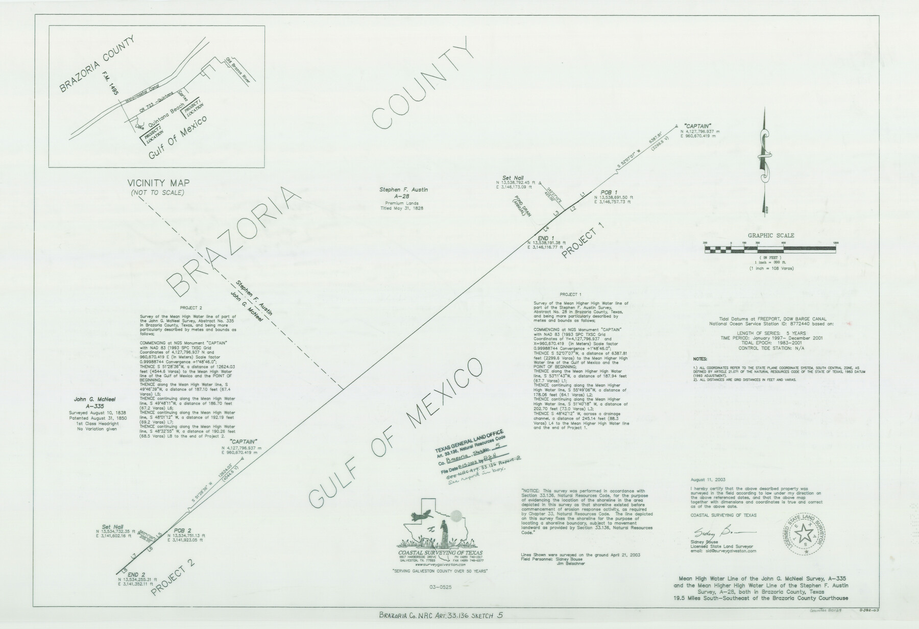
Brazoria County NRC Article 33.136 Sketch 5
Mean High Water Line of The John G. McNeel Survey, Abstract 335 and The Mean Higher High Water Line of The Stephen F. Austin Survey, Abstract 28, Quintana Beach
-
Map/Doc
80124
-
Collection
General Map Collection
-
Object Dates
2003/8/11 (Creation Date)
2003/9/15 (File Date)
-
People and Organizations
Coastal Surveying of Texas (Publisher)
Coastal Surveying of Texas (Printer)
Sidney Bouse (Surveyor/Engineer)
-
Counties
Brazoria
-
Subjects
Surveying CBS
-
Height x Width
24.2 x 35.4 inches
61.5 x 89.9 cm
-
Medium
multi-page, multi-format
-
Comments
Survey located 18 1/2 miles South 22 degrees East of Angleton, Texas.
One or more items in this file were formerly filed in another file. They have been reunited in this file with their original grouping. The old name on these sheets has been crossed
Part of: General Map Collection
Brazoria County Working Sketch 29

Print $20.00
- Digital $50.00
Brazoria County Working Sketch 29
1971
Size 30.6 x 28.3 inches
Map/Doc 67514
Lampasas County Boundary File 4a

Print $12.00
- Digital $50.00
Lampasas County Boundary File 4a
Size 12.8 x 8.2 inches
Map/Doc 56122
Parker County Sketch File 23

Print $20.00
- Digital $50.00
Parker County Sketch File 23
1876
Size 18.8 x 22.8 inches
Map/Doc 12145
Brazoria County NRC Article 33.136 Sketch 7

Print $21.00
- Digital $50.00
Brazoria County NRC Article 33.136 Sketch 7
2004
Size 23.7 x 33.3 inches
Map/Doc 82907
Calcasieu Pass to Sabine Pass

Print $20.00
- Digital $50.00
Calcasieu Pass to Sabine Pass
1992
Size 44.5 x 35.8 inches
Map/Doc 69815
Brazos River, Brazos River Sheet 5

Print $20.00
- Digital $50.00
Brazos River, Brazos River Sheet 5
1926
Size 27.4 x 21.7 inches
Map/Doc 69669
Kimble County Working Sketch 8

Print $20.00
- Digital $50.00
Kimble County Working Sketch 8
1918
Size 27.4 x 12.9 inches
Map/Doc 70076
Henderson County Rolled Sketch 14

Print $20.00
- Digital $50.00
Henderson County Rolled Sketch 14
2012
Size 19.3 x 32.3 inches
Map/Doc 95715
Real County Working Sketch 13

Print $20.00
- Digital $50.00
Real County Working Sketch 13
1931
Size 24.2 x 33.3 inches
Map/Doc 71905
Orange County Rolled Sketch 13

Print $20.00
- Digital $50.00
Orange County Rolled Sketch 13
Size 19.0 x 24.2 inches
Map/Doc 7180
Willacy County Working Sketch Graphic Index

Print $20.00
- Digital $50.00
Willacy County Working Sketch Graphic Index
1921
Size 32.8 x 32.7 inches
Map/Doc 76741
La Salle County Working Sketch 48

Print $20.00
- Digital $50.00
La Salle County Working Sketch 48
1983
Size 26.2 x 36.0 inches
Map/Doc 70349
You may also like
Young County Sketch File 21

Print $20.00
- Digital $50.00
Young County Sketch File 21
1954
Size 19.0 x 23.0 inches
Map/Doc 12715
Val Verde County Working Sketch 94

Print $20.00
- Digital $50.00
Val Verde County Working Sketch 94
1979
Size 31.6 x 42.3 inches
Map/Doc 72229
San Augustine County Sketch File 3

Print $10.00
San Augustine County Sketch File 3
1858
Size 11.8 x 8.1 inches
Map/Doc 35635
Crockett County Sketch File 67

Print $20.00
- Digital $50.00
Crockett County Sketch File 67
1927
Size 30.1 x 26.6 inches
Map/Doc 11231
[Right of Way Map, Belton Branch of the M.K.&T. RR.]
![64227, [Right of Way Map, Belton Branch of the M.K.&T. RR.], General Map Collection](https://historictexasmaps.com/wmedia_w700/maps/64227.tif.jpg)
Print $20.00
- Digital $50.00
[Right of Way Map, Belton Branch of the M.K.&T. RR.]
1896
Size 22.0 x 7.2 inches
Map/Doc 64227
Dallas County Working Sketch 19

Print $20.00
- Digital $50.00
Dallas County Working Sketch 19
1997
Size 23.1 x 30.3 inches
Map/Doc 68585
C. B. Livestock Co.'s West-Ranch, Bailey County, Texas

Print $2.00
- Digital $50.00
C. B. Livestock Co.'s West-Ranch, Bailey County, Texas
Size 8.8 x 11.2 inches
Map/Doc 90380
Leon County Rolled Sketch 31

Print $20.00
- Digital $50.00
Leon County Rolled Sketch 31
1990
Size 44.5 x 32.7 inches
Map/Doc 6614
Howard County Working Sketch 13

Print $20.00
- Digital $50.00
Howard County Working Sketch 13
1983
Size 33.3 x 37.3 inches
Map/Doc 66281
Brazos Santiago & Boca Chica entrances, Texas

Print $20.00
- Digital $50.00
Brazos Santiago & Boca Chica entrances, Texas
1867
Size 18.1 x 25.6 inches
Map/Doc 72927
Texas, Empire State of the Southwest

Texas, Empire State of the Southwest
1911
Size 7.9 x 5.5 inches
Map/Doc 96604
Burleson County Working Sketch 23

Print $20.00
- Digital $50.00
Burleson County Working Sketch 23
1980
Size 17.9 x 16.6 inches
Map/Doc 67742