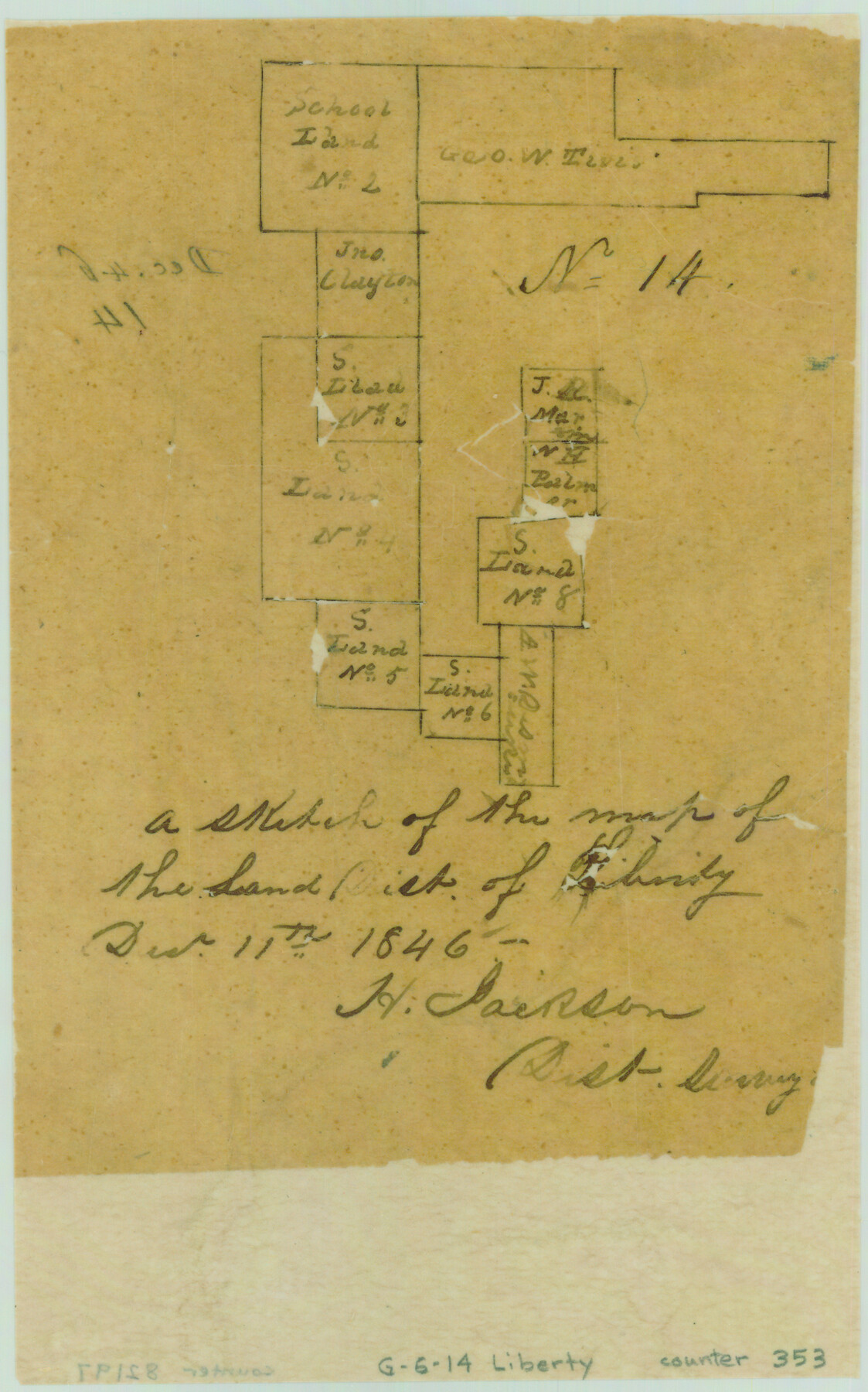
A sketch of the map of the Land Dist. of Liberty
Atlas G, Page 6, Sketch 14 (G-6-14)
G-6-14
-
Map/Doc
353
-
Collection
General Map Collection
-
Counties
Polk Tyler
-
Subjects
Atlas
-
Height x Width
6.3 x 3.9 inches
16.0 x 9.9 cm
-
Medium
paper, manuscript
-
Comments
Conserved in 2003.
Part of: General Map Collection
Polk County Sketch File 35

Print $8.00
- Digital $50.00
Polk County Sketch File 35
1891
Size 14.2 x 8.7 inches
Map/Doc 34232
East Half - Brown County

Print $40.00
- Digital $50.00
East Half - Brown County
1982
Size 141.3 x 36.8 inches
Map/Doc 97385
Hunt County Rolled Sketch 5

Print $20.00
- Digital $50.00
Hunt County Rolled Sketch 5
1956
Size 27.6 x 24.8 inches
Map/Doc 6270
Tarrant County Working Sketch 27

Print $20.00
- Digital $50.00
Tarrant County Working Sketch 27
2010
Size 19.4 x 35.9 inches
Map/Doc 89261
Nueces County NRC Article 33.136 Sketch 1

Print $274.00
- Digital $50.00
Nueces County NRC Article 33.136 Sketch 1
2002
Size 24.5 x 36.3 inches
Map/Doc 87920
Uvalde County Working Sketch 66

Print $20.00
- Digital $50.00
Uvalde County Working Sketch 66
1942
Size 20.9 x 21.3 inches
Map/Doc 75968
Edwards County Working Sketch 20

Print $20.00
- Digital $50.00
Edwards County Working Sketch 20
1935
Size 43.2 x 42.6 inches
Map/Doc 68896
Crosby County Sketch File 1a

Print $6.00
- Digital $50.00
Crosby County Sketch File 1a
1874
Size 11.0 x 14.2 inches
Map/Doc 19987
Dawson County Working Sketch 7

Print $20.00
- Digital $50.00
Dawson County Working Sketch 7
1942
Size 15.3 x 26.1 inches
Map/Doc 68551
Jefferson County NRC Article 33.136 Sketch 10

Print $28.00
- Digital $50.00
Jefferson County NRC Article 33.136 Sketch 10
2012
Size 24.0 x 36.0 inches
Map/Doc 94575
Fayette County Boundary File 1

Print $2.00
- Digital $50.00
Fayette County Boundary File 1
Size 11.1 x 8.7 inches
Map/Doc 53330
Duval County Working Sketch 44

Print $20.00
- Digital $50.00
Duval County Working Sketch 44
1977
Size 27.5 x 40.7 inches
Map/Doc 68768
You may also like
[Part of Block D7]
![91944, [Part of Block D7], Twichell Survey Records](https://historictexasmaps.com/wmedia_w700/maps/91944-1.tif.jpg)
Print $20.00
- Digital $50.00
[Part of Block D7]
Size 36.5 x 18.8 inches
Map/Doc 91944
Hockley County

Print $20.00
- Digital $50.00
Hockley County
1954
Size 42.7 x 38.2 inches
Map/Doc 73181
[League in the South Part of Lamb County]
![91052, [League in the South Part of Lamb County], Twichell Survey Records](https://historictexasmaps.com/wmedia_w700/maps/91052-1.tif.jpg)
Print $20.00
- Digital $50.00
[League in the South Part of Lamb County]
Size 30.4 x 34.1 inches
Map/Doc 91052
Map of Starr County

Print $20.00
- Digital $50.00
Map of Starr County
1896
Size 43.7 x 26.9 inches
Map/Doc 4050
Stonewall County Rolled Sketch 14

Print $20.00
- Digital $50.00
Stonewall County Rolled Sketch 14
1902
Size 32.9 x 25.2 inches
Map/Doc 7869
Map of north end of Brazos Island

Print $20.00
- Digital $50.00
Map of north end of Brazos Island
Size 27.6 x 18.2 inches
Map/Doc 72908
[F. W. & D. C. Ry. Co. Alignment and Right of Way Map, Clay County]
![64723, [F. W. & D. C. Ry. Co. Alignment and Right of Way Map, Clay County], General Map Collection](https://historictexasmaps.com/wmedia_w700/maps/64723-1.tif.jpg)
Print $20.00
- Digital $50.00
[F. W. & D. C. Ry. Co. Alignment and Right of Way Map, Clay County]
1927
Size 18.6 x 11.8 inches
Map/Doc 64723
Harris County Rolled Sketch J

Print $40.00
- Digital $50.00
Harris County Rolled Sketch J
1933
Size 53.6 x 41.6 inches
Map/Doc 9122
Approaches to Galveston Bay

Print $40.00
- Digital $50.00
Approaches to Galveston Bay
1992
Size 36.6 x 55.6 inches
Map/Doc 69888
Anderson County Working Sketch 8

Print $20.00
- Digital $50.00
Anderson County Working Sketch 8
1923
Size 18.6 x 20.6 inches
Map/Doc 67007
Parker County Sketch File 7

Print $26.00
- Digital $50.00
Parker County Sketch File 7
1859
Size 12.4 x 7.9 inches
Map/Doc 33533
[Blocks B5, B6 and Capitol Land Reservation]
![93014, [Blocks B5, B6 and Capitol Land Reservation], Twichell Survey Records](https://historictexasmaps.com/wmedia_w700/maps/93014-1.tif.jpg)
Print $20.00
- Digital $50.00
[Blocks B5, B6 and Capitol Land Reservation]
Size 20.6 x 18.6 inches
Map/Doc 93014