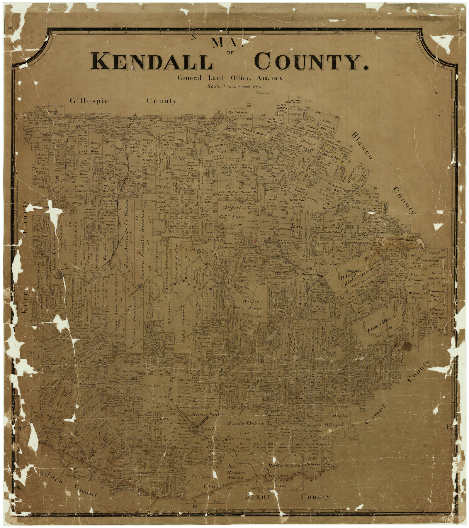
Map of Kendall County
-
Map/Doc
4678
-
Collection
General Map Collection
-
Object Dates
8/1899 (Creation Date)
-
People and Organizations
Texas General Land Office (Publisher)
Hunnicutt (Draftsman)
Hunnicutt (Compiler)
-
Counties
Kendall
-
Subjects
County
-
Height x Width
37.9 x 33.9 inches
96.3 x 86.1 cm
-
Comments
Conservation funded in 2001 with donation from Frost Bank.
-
Features
Walter's Creek
Holiday's Creek
Waring
West Fork of Joshua's Creek
East Fork [of Curry's Creek]
Violet Creek
Wasp Creek
Goss Creek
Curry's Creek
Simmon's Creek
Honey Creek
North Creek
Swede's Creek
Spring Creek
Boerne
SA&AP
Cibolo River
Pipe Creek
Friedrich Creek
Menger Creek
Balcones Creek
Middle Fork [of Curry's Creek]
Martins Fork of Blanco River
SAF&N
Fredericksburg Junction
Sabinas River
Cypress Creek
Nichols
Twin Sisters
Twin Brothers
Kendalia
Mount Alamo [Station]
Kaiser's Creek
West Fork [of Curry's Creek]
Sisterdale
Syster Creek
Guadalupe River
Sabinas Creek
Flatrock Creek
Comfort
Hillington
Part of: General Map Collection
[Galveston, Harrisburg & San Antonio through El Paso County]
![64012, [Galveston, Harrisburg & San Antonio through El Paso County], General Map Collection](https://historictexasmaps.com/wmedia_w700/maps/64012.tif.jpg)
Print $20.00
- Digital $50.00
[Galveston, Harrisburg & San Antonio through El Paso County]
1906
Size 13.6 x 33.8 inches
Map/Doc 64012

Flight Mission No. CGI-1N, Frame 134, Cameron County

Print $20.00
- Digital $50.00
Flight Mission No. CGI-1N, Frame 134, Cameron County
1955
Size 18.5 x 22.1 inches
Map/Doc 84490
Schleicher County Sketch File 47

Print $4.00
- Digital $50.00
Schleicher County Sketch File 47
1953
Size 4.4 x 8.7 inches
Map/Doc 36556
Flight Mission No. BRA-16M, Frame 173, Jefferson County

Print $20.00
- Digital $50.00
Flight Mission No. BRA-16M, Frame 173, Jefferson County
1953
Size 18.5 x 22.2 inches
Map/Doc 85771
Callahan County Working Sketch 7

Print $20.00
- Digital $50.00
Callahan County Working Sketch 7
1955
Size 25.1 x 12.7 inches
Map/Doc 67889
Donley County Rolled Sketch 6

Print $40.00
- Digital $50.00
Donley County Rolled Sketch 6
1982
Size 42.9 x 66.6 inches
Map/Doc 8802
Flight Mission No. DAG-21K, Frame 109, Matagorda County

Print $20.00
- Digital $50.00
Flight Mission No. DAG-21K, Frame 109, Matagorda County
1952
Size 18.6 x 22.3 inches
Map/Doc 86437
Foard County Working Sketch Graphic Index

Print $20.00
- Digital $50.00
Foard County Working Sketch Graphic Index
1945
Size 37.8 x 41.3 inches
Map/Doc 76544
Webb County Rolled Sketch 73

Print $20.00
- Digital $50.00
Webb County Rolled Sketch 73
1982
Size 33.2 x 17.2 inches
Map/Doc 8221
Texas-Louisiana Gulf Coastal Region showing Oil & Gas Fields & Prospects, Pipe Lines, Refineries & Principal Highways

Print $20.00
- Digital $50.00
Texas-Louisiana Gulf Coastal Region showing Oil & Gas Fields & Prospects, Pipe Lines, Refineries & Principal Highways
1933
Size 22.4 x 44.2 inches
Map/Doc 96874
Cameron County Rolled Sketch Z2

Print $20.00
- Digital $50.00
Cameron County Rolled Sketch Z2
1937
Size 23.7 x 40.9 inches
Map/Doc 5402
You may also like
Right-of-Way & Track Map, Houston and Brazos Valley Ry. Co. operated by the Houston and Brazos Valley Ry. Co.

Print $40.00
- Digital $50.00
Right-of-Way & Track Map, Houston and Brazos Valley Ry. Co. operated by the Houston and Brazos Valley Ry. Co.
1918
Size 25.0 x 55.7 inches
Map/Doc 64605
Presidio County Sketch File 82

Print $22.00
- Digital $50.00
Presidio County Sketch File 82
1949
Size 14.3 x 8.8 inches
Map/Doc 34711
Cooke County Sketch File 38 1/2

Print $20.00
- Digital $50.00
Cooke County Sketch File 38 1/2
Size 21.5 x 16.6 inches
Map/Doc 11175
[Sketch for Mineral Application 26501 - Sabine River, T. A. Oldhausen]
![2832, [Sketch for Mineral Application 26501 - Sabine River, T. A. Oldhausen], General Map Collection](https://historictexasmaps.com/wmedia_w700/maps/2832.tif.jpg)
Print $20.00
- Digital $50.00
[Sketch for Mineral Application 26501 - Sabine River, T. A. Oldhausen]
1931
Size 24.0 x 36.0 inches
Map/Doc 2832
Terrell County

Print $40.00
- Digital $50.00
Terrell County
1931
Size 48.9 x 39.9 inches
Map/Doc 95651
Duval County Working Sketch 6

Print $20.00
- Digital $50.00
Duval County Working Sketch 6
1935
Size 26.9 x 21.8 inches
Map/Doc 68719
Harris County Boundary File 39 (11)

Print $8.00
- Digital $50.00
Harris County Boundary File 39 (11)
Size 12.8 x 8.0 inches
Map/Doc 54335
Kimble County

Print $40.00
- Digital $50.00
Kimble County
1890
Size 38.8 x 58.1 inches
Map/Doc 78414
Flight Mission No. CRC-3R, Frame 21, Chambers County

Print $20.00
- Digital $50.00
Flight Mission No. CRC-3R, Frame 21, Chambers County
1956
Size 18.6 x 22.2 inches
Map/Doc 84795
Reconnoissance of Sabine River and Valley

Print $20.00
Reconnoissance of Sabine River and Valley
1863
Size 30.2 x 42.3 inches
Map/Doc 97499
Midland County Sketch File 7

Print $20.00
- Digital $50.00
Midland County Sketch File 7
1930
Size 33.1 x 23.7 inches
Map/Doc 12083
Orange County NRC Article 33.136 Sketch 4

Print $24.00
- Digital $50.00
Orange County NRC Article 33.136 Sketch 4
2011
Size 22.6 x 31.2 inches
Map/Doc 93271