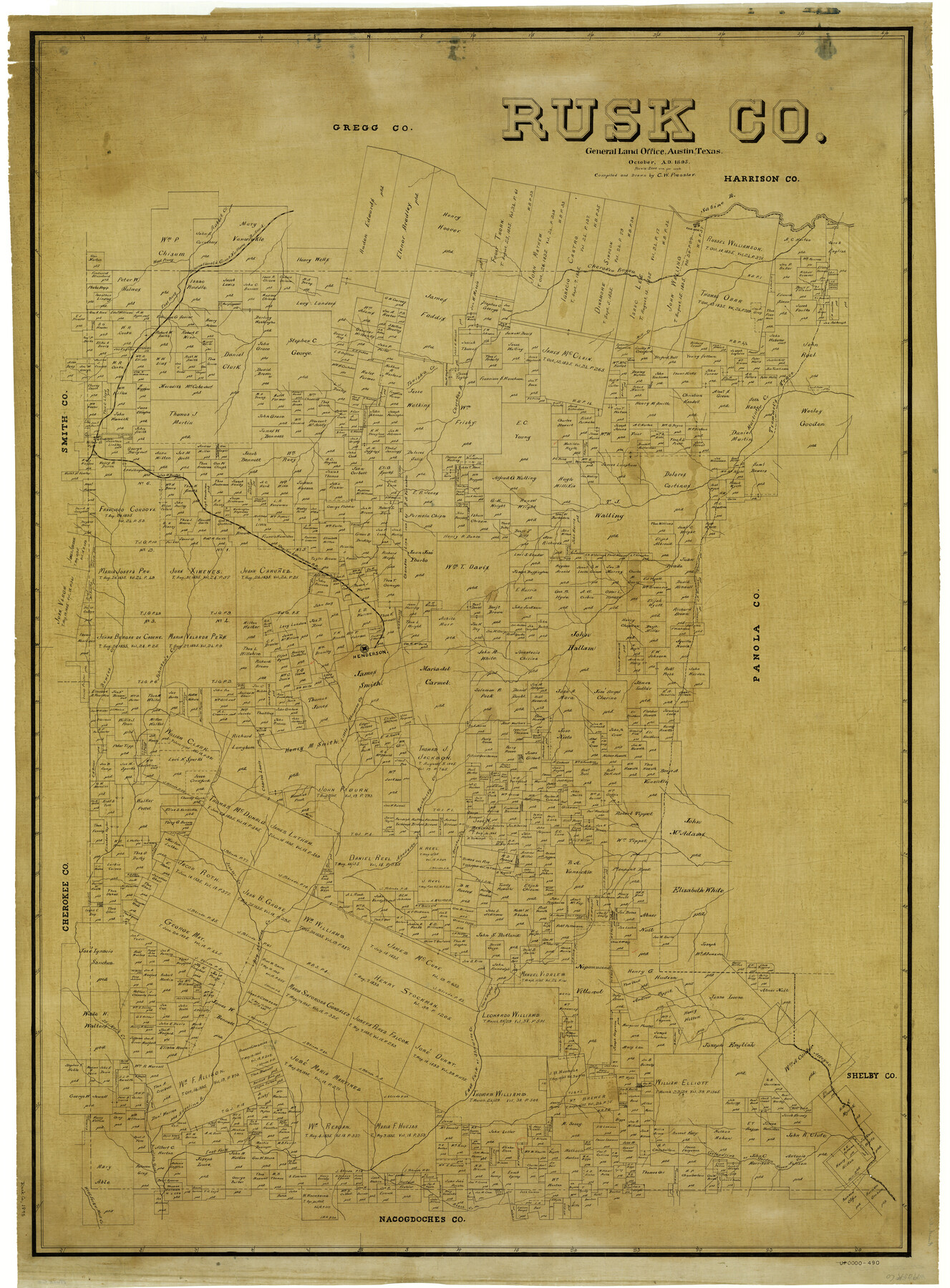
Rusk Co.
-
Map/Doc
5025
-
Collection
General Map Collection
-
Object Dates
1895 (Creation Date)
-
People and Organizations
Texas General Land Office (Publisher)
Chas. W. Pressler (Draftsman)
Chas. W. Pressler (Compiler)
-
Counties
Rusk
-
Subjects
County
-
Height x Width
47.4 x 34.9 inches
120.4 x 88.6 cm
Part of: General Map Collection
[Sketch for Mineral Application 16787 - Pecos River Bed, A. T. Freet]
![2816, [Sketch for Mineral Application 16787 - Pecos River Bed, A. T. Freet], General Map Collection](https://historictexasmaps.com/wmedia_w700/maps/2816-1.tif.jpg)
Print $20.00
- Digital $50.00
[Sketch for Mineral Application 16787 - Pecos River Bed, A. T. Freet]
1927
Size 18.4 x 32.7 inches
Map/Doc 2816
Sulphur River, Ringo Crossing Sheet

Print $20.00
- Digital $50.00
Sulphur River, Ringo Crossing Sheet
1933
Size 30.5 x 35.9 inches
Map/Doc 65162
Flight Mission No. BQY-4M, Frame 119, Harris County

Print $20.00
- Digital $50.00
Flight Mission No. BQY-4M, Frame 119, Harris County
1953
Size 18.7 x 22.4 inches
Map/Doc 85287
Bell County Sketch File 31

Print $4.00
- Digital $50.00
Bell County Sketch File 31
1882
Size 8.0 x 8.9 inches
Map/Doc 14445
Flight Mission No. CRK-5P, Frame 159, Refugio County

Print $20.00
- Digital $50.00
Flight Mission No. CRK-5P, Frame 159, Refugio County
1956
Size 18.6 x 22.5 inches
Map/Doc 86940
Aransas County Rolled Sketch 11

Print $20.00
- Digital $50.00
Aransas County Rolled Sketch 11
Size 42.0 x 36.4 inches
Map/Doc 8410
Zavala County Rolled Sketch 32

Print $20.00
- Digital $50.00
Zavala County Rolled Sketch 32
Size 22.5 x 38.2 inches
Map/Doc 8333
Wharton County

Print $40.00
- Digital $50.00
Wharton County
1946
Size 43.1 x 49.7 inches
Map/Doc 95671
Stonewall County Rolled Sketch 11

Print $20.00
- Digital $50.00
Stonewall County Rolled Sketch 11
Size 33.2 x 28.1 inches
Map/Doc 7867
[Surveys in Power and Hewetson's Colony along the Aransas River, Middle Creek, Papalose Creek, and Blanco Creek]
![81, [Surveys in Power and Hewetson's Colony along the Aransas River, Middle Creek, Papalose Creek, and Blanco Creek], General Map Collection](https://historictexasmaps.com/wmedia_w700/maps/81.tif.jpg)
Print $20.00
- Digital $50.00
[Surveys in Power and Hewetson's Colony along the Aransas River, Middle Creek, Papalose Creek, and Blanco Creek]
1830
Size 21.6 x 21.2 inches
Map/Doc 81
Flight Mission No. CRE-2R, Frame 89, Jackson County

Print $20.00
- Digital $50.00
Flight Mission No. CRE-2R, Frame 89, Jackson County
1956
Size 18.6 x 22.2 inches
Map/Doc 85361
Grid Map Showing Texas, Louisiana, Arkansas, Mississippi and portions of New Mexico, Oklahoma and Tennessee

Print $40.00
- Digital $50.00
Grid Map Showing Texas, Louisiana, Arkansas, Mississippi and portions of New Mexico, Oklahoma and Tennessee
1940
Size 34.2 x 48.1 inches
Map/Doc 3121
You may also like
Hockley City Located on Labors 7, 8, 13, and 14 of Hood County School League Number 28 Situated in Hockley County, Texas

Print $20.00
- Digital $50.00
Hockley City Located on Labors 7, 8, 13, and 14 of Hood County School League Number 28 Situated in Hockley County, Texas
Size 24.2 x 30.8 inches
Map/Doc 92239
Map of Mitchell County, Texas

Print $20.00
Map of Mitchell County, Texas
1890
Size 23.4 x 18.9 inches
Map/Doc 88980
Reeves County Sketch File 12

Print $20.00
- Digital $50.00
Reeves County Sketch File 12
Size 42.7 x 31.3 inches
Map/Doc 10588
Concho County Working Sketch 1

Print $20.00
- Digital $50.00
Concho County Working Sketch 1
Size 29.3 x 36.8 inches
Map/Doc 68183
Flight Mission No. DQN-2K, Frame 147, Calhoun County

Print $20.00
- Digital $50.00
Flight Mission No. DQN-2K, Frame 147, Calhoun County
1953
Size 19.0 x 22.6 inches
Map/Doc 84316
Tarrant County Working Sketch 1

Print $20.00
- Digital $50.00
Tarrant County Working Sketch 1
1939
Size 12.2 x 18.9 inches
Map/Doc 62418

Baylor County Working Sketch 13

Print $20.00
- Digital $50.00
Baylor County Working Sketch 13
1961
Size 22.4 x 20.0 inches
Map/Doc 67298
The Republic County of Robertson. Created, December 14, 1837

Print $20.00
The Republic County of Robertson. Created, December 14, 1837
2020
Size 18.9 x 21.6 inches
Map/Doc 96259

Martin County Sketch

Print $20.00
- Digital $50.00
Martin County Sketch
1924
Size 14.3 x 17.2 inches
Map/Doc 92269
Matagorda County Rolled Sketch 31

Print $187.00
- Digital $50.00
Matagorda County Rolled Sketch 31
Size 10.6 x 15.5 inches
Map/Doc 46654