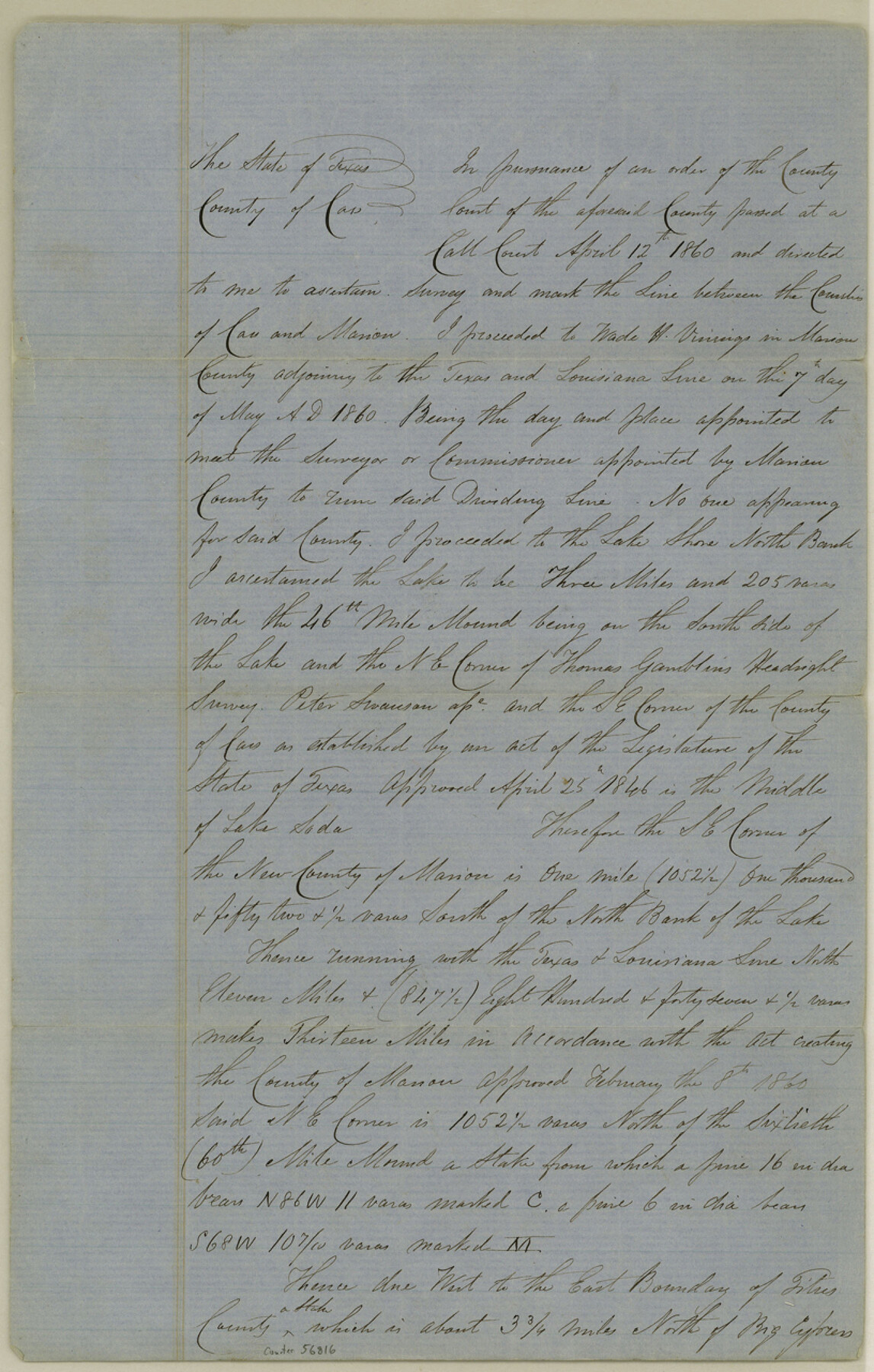
Marion County Boundary File 61
The Dividing Line between the Counties of Cass and Marion
-
Map/Doc
56816
-
Collection
General Map Collection
-
Counties
Marion
-
Subjects
County Boundaries
-
Height x Width
12.8 x 8.2 inches
32.5 x 20.8 cm
Part of: General Map Collection
Val Verde County Working Sketch 24

Print $20.00
- Digital $50.00
Val Verde County Working Sketch 24
1936
Size 21.5 x 21.6 inches
Map/Doc 72159
Flight Mission No. CLL-1N, Frame 39, Willacy County

Print $20.00
- Digital $50.00
Flight Mission No. CLL-1N, Frame 39, Willacy County
1954
Size 18.4 x 22.0 inches
Map/Doc 87020
Knox County Boundary File 5

Print $14.00
- Digital $50.00
Knox County Boundary File 5
Size 14.2 x 8.6 inches
Map/Doc 65040
Map of Tom Green County

Print $20.00
- Digital $50.00
Map of Tom Green County
1892
Size 44.0 x 45.1 inches
Map/Doc 63068
Travis County Sketch File 34

Print $26.00
- Digital $50.00
Travis County Sketch File 34
1888
Size 26.8 x 27.9 inches
Map/Doc 12461
Harrison County Sketch File 4

Print $4.00
- Digital $50.00
Harrison County Sketch File 4
Size 9.0 x 8.0 inches
Map/Doc 26040
Pecos County Rolled Sketch 146

Print $20.00
- Digital $50.00
Pecos County Rolled Sketch 146
Size 40.8 x 32.5 inches
Map/Doc 9734
Map of Africa engraved to illustrate Mitchell's school and family geography (Inset 1: Map of Egypt / Inset 2: Map of Liberia)

Print $20.00
- Digital $50.00
Map of Africa engraved to illustrate Mitchell's school and family geography (Inset 1: Map of Egypt / Inset 2: Map of Liberia)
1839
Size 9.5 x 11.8 inches
Map/Doc 93507
Flight Mission No. BQR-5K, Frame 64, Brazoria County

Print $20.00
- Digital $50.00
Flight Mission No. BQR-5K, Frame 64, Brazoria County
1952
Size 18.8 x 22.5 inches
Map/Doc 84009
Denton County Sketch File 19

Print $10.00
- Digital $50.00
Denton County Sketch File 19
Size 10.0 x 7.3 inches
Map/Doc 20733
El Paso County Rolled Sketch 52

Print $20.00
- Digital $50.00
El Paso County Rolled Sketch 52
1929
Size 18.4 x 24.4 inches
Map/Doc 5844
Presidio County Sketch File 70b

Print $6.00
- Digital $50.00
Presidio County Sketch File 70b
Size 11.2 x 8.9 inches
Map/Doc 34671
You may also like
Flight Mission No. DCL-7C, Frame 3, Kenedy County

Print $20.00
- Digital $50.00
Flight Mission No. DCL-7C, Frame 3, Kenedy County
1943
Size 18.5 x 22.3 inches
Map/Doc 85995
Yoakum County

Print $20.00
- Digital $50.00
Yoakum County
1932
Size 45.7 x 34.1 inches
Map/Doc 73331
Ward County Working Sketch 26

Print $20.00
- Digital $50.00
Ward County Working Sketch 26
1964
Size 38.2 x 24.5 inches
Map/Doc 72332
Pecos County Sketch File 97

Print $6.00
- Digital $50.00
Pecos County Sketch File 97
1957
Size 11.4 x 17.2 inches
Map/Doc 34000
Fractional Township No. 8 South Range No. 1 West of the Indian Meridian, Indian Territory

Print $20.00
- Digital $50.00
Fractional Township No. 8 South Range No. 1 West of the Indian Meridian, Indian Territory
1898
Size 19.2 x 24.4 inches
Map/Doc 75198
Proceedings of The International (Water) Boundary Commission United States and Mexico Treaties of 1884 and 1889, Volume 1

Proceedings of The International (Water) Boundary Commission United States and Mexico Treaties of 1884 and 1889, Volume 1
Map/Doc 83144
Young County Boundary File 1

Print $8.00
- Digital $50.00
Young County Boundary File 1
Size 10.3 x 8.2 inches
Map/Doc 60198
[Houston & Texas Central Ry.]
![64363, [Houston & Texas Central Ry.], General Map Collection](https://historictexasmaps.com/wmedia_w700/maps/64363.tif.jpg)
Print $20.00
- Digital $50.00
[Houston & Texas Central Ry.]
1939
Size 15.5 x 13.8 inches
Map/Doc 64363
San Patricio County, Texas

Print $20.00
- Digital $50.00
San Patricio County, Texas
1879
Size 18.1 x 22.8 inches
Map/Doc 611
Flight Mission No. DQO-11K, Frame 23, Galveston County

Print $20.00
- Digital $50.00
Flight Mission No. DQO-11K, Frame 23, Galveston County
1952
Size 18.8 x 22.4 inches
Map/Doc 85220
Burleson County Working Sketch 3

Print $20.00
- Digital $50.00
Burleson County Working Sketch 3
1979
Size 26.5 x 22.5 inches
Map/Doc 67722
Historia de Nueva-España, escrita por su esclarecido conquistador Hernan Cortes, aumentada con otros documentos, y notas, por el ilustrissimo señor don Francisco Antonio Lorenzana, Arzobispo de Mexico

Historia de Nueva-España, escrita por su esclarecido conquistador Hernan Cortes, aumentada con otros documentos, y notas, por el ilustrissimo señor don Francisco Antonio Lorenzana, Arzobispo de Mexico
1770
Map/Doc 97351