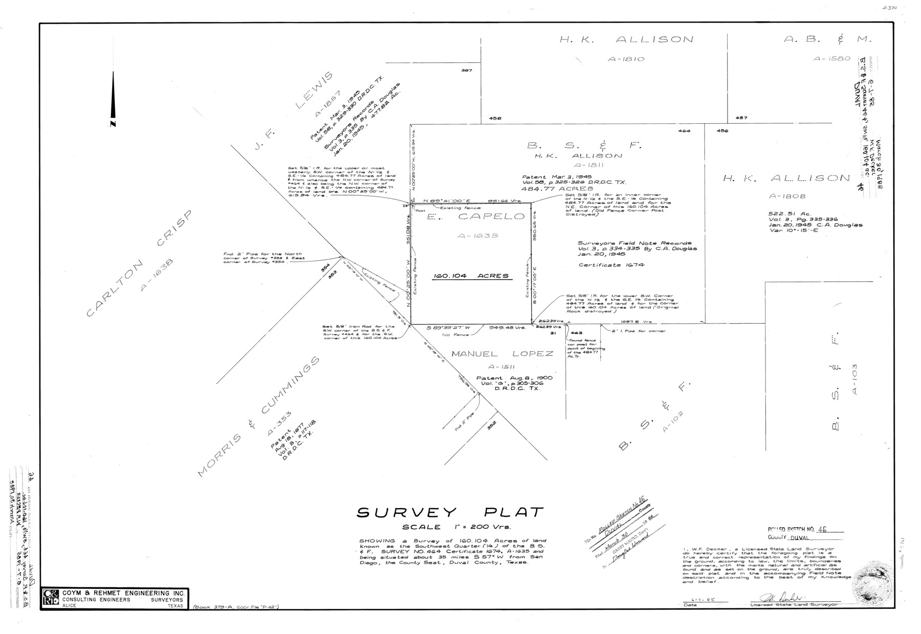
Duval County Rolled Sketch 46
Survey plat showing a survey of 160.104 acres of land known as the southwest quarter (1/4) of the B. S. & F. survey no. 464, certificate 1674, A-1635
-
Map/Doc
5761
-
Collection
General Map Collection
-
Object Dates
1985/6/7 (Creation Date)
1988/3/30 (File Date)
-
People and Organizations
W.F. Decker (Surveyor/Engineer)
-
Counties
Duval
-
Subjects
Surveying Rolled Sketch
-
Height x Width
24.9 x 36.1 inches
63.2 x 91.7 cm
-
Scale
1" = 200 varas
Part of: General Map Collection
Archer County Sketch File 8

Print $40.00
- Digital $50.00
Archer County Sketch File 8
Size 40.9 x 31.5 inches
Map/Doc 10336
Map of a part of Fisher and Miller's Colony - Harvey's District

Print $20.00
- Digital $50.00
Map of a part of Fisher and Miller's Colony - Harvey's District
1856
Size 15.2 x 19.8 inches
Map/Doc 1972
Flight Mission No. DQO-1K, Frame 156, Galveston County

Print $20.00
- Digital $50.00
Flight Mission No. DQO-1K, Frame 156, Galveston County
1952
Size 18.8 x 22.4 inches
Map/Doc 85009
Reeves County Working Sketch 38

Print $20.00
- Digital $50.00
Reeves County Working Sketch 38
1971
Size 36.4 x 39.0 inches
Map/Doc 63481
Flight Mission No. CRC-2R, Frame 185, Chambers County

Print $20.00
- Digital $50.00
Flight Mission No. CRC-2R, Frame 185, Chambers County
1956
Size 18.8 x 22.4 inches
Map/Doc 84763
Culberson County Rolled Sketch 49

Print $20.00
- Digital $50.00
Culberson County Rolled Sketch 49
1961
Size 22.4 x 29.0 inches
Map/Doc 5668
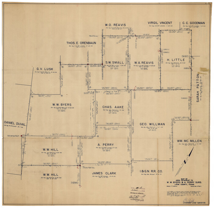
Leon County Rolled Sketch 4
Print $20.00
- Digital $50.00
Leon County Rolled Sketch 4
1947
Size 34.6 x 35.4 inches
Map/Doc 9426
Kerr County Rolled Sketch 20

Print $20.00
- Digital $50.00
Kerr County Rolled Sketch 20
1955
Size 30.2 x 35.2 inches
Map/Doc 6502
Wichita County Sketch File 12a

Print $10.00
- Digital $50.00
Wichita County Sketch File 12a
1881
Size 14.2 x 8.6 inches
Map/Doc 40077
[Sketch for Mineral Application 1487 -Big Wichita River, Ernest R. Smith]
![65684, [Sketch for Mineral Application 1487 -Big Wichita River, Ernest R. Smith], General Map Collection](https://historictexasmaps.com/wmedia_w700/maps/65684.tif.jpg)
Print $40.00
- Digital $50.00
[Sketch for Mineral Application 1487 -Big Wichita River, Ernest R. Smith]
1918
Size 32.2 x 130.1 inches
Map/Doc 65684
[Atlas C, Table of Contents]
![78353, [Atlas C, Table of Contents], General Map Collection](https://historictexasmaps.com/wmedia_w700/maps/78353.tif.jpg)
Print $3.00
- Digital $50.00
[Atlas C, Table of Contents]
Size 14.7 x 9.6 inches
Map/Doc 78353
Map of the Reconnaissance in Texas by Lieuts Blake & Meade of the Corps of Topl. Engrs.

Print $20.00
- Digital $50.00
Map of the Reconnaissance in Texas by Lieuts Blake & Meade of the Corps of Topl. Engrs.
1845
Size 27.6 x 18.2 inches
Map/Doc 72891
You may also like
Val Verde County Sketch File 6a

Print $14.00
- Digital $50.00
Val Verde County Sketch File 6a
1895
Size 7.4 x 8.7 inches
Map/Doc 39191
Cooke County Sketch File 45

Print $20.00
- Digital $50.00
Cooke County Sketch File 45
1849
Size 22.3 x 15.2 inches
Map/Doc 11179
Webb County Sketch File 3-1

Print $20.00
- Digital $50.00
Webb County Sketch File 3-1
1875
Size 28.0 x 22.8 inches
Map/Doc 12614
Crane County Working Sketch 23

Print $20.00
- Digital $50.00
Crane County Working Sketch 23
1963
Size 25.8 x 23.2 inches
Map/Doc 68300
Pecos County Working Sketch 37

Print $20.00
- Digital $50.00
Pecos County Working Sketch 37
1939
Size 30.0 x 43.0 inches
Map/Doc 71509
Intracoastal Waterway, Houma, LA to Corpus Christi, TX

Print $20.00
- Digital $50.00
Intracoastal Waterway, Houma, LA to Corpus Christi, TX
Size 18.7 x 30.2 inches
Map/Doc 61908
Jefferson County NRC Article 33.136 Location Key Sheet

Print $20.00
- Digital $50.00
Jefferson County NRC Article 33.136 Location Key Sheet
1974
Size 27.0 x 23.0 inches
Map/Doc 77029
Real County Working Sketch 46

Print $20.00
- Digital $50.00
Real County Working Sketch 46
1956
Size 21.2 x 18.9 inches
Map/Doc 71938
Map of Texas showing the Sabine and Galveston Bay Rail Road, or Texas and New Orleans Air Line Rail Line, its connections in the U.S. and adjacent territories.

Print $20.00
Map of Texas showing the Sabine and Galveston Bay Rail Road, or Texas and New Orleans Air Line Rail Line, its connections in the U.S. and adjacent territories.
1859
Size 28.7 x 41.3 inches
Map/Doc 93610
Index sheet to accompany map of survey for connecting the inland waters along margin of the Gulf of Mexico from Donaldsonville in Louisiana to the Rio Grande River in Texas

Print $20.00
- Digital $50.00
Index sheet to accompany map of survey for connecting the inland waters along margin of the Gulf of Mexico from Donaldsonville in Louisiana to the Rio Grande River in Texas
1873
Size 18.2 x 28.2 inches
Map/Doc 72693
[Map of Navarro County]
![81900, [Map of Navarro County], General Map Collection](https://historictexasmaps.com/wmedia_w700/maps/81900.tif.jpg)
Print $20.00
- Digital $50.00
[Map of Navarro County]
1858
Size 18.0 x 23.5 inches
Map/Doc 81900
Val Verde County Working Sketch 44

Print $40.00
- Digital $50.00
Val Verde County Working Sketch 44
1945
Size 49.7 x 39.5 inches
Map/Doc 72179