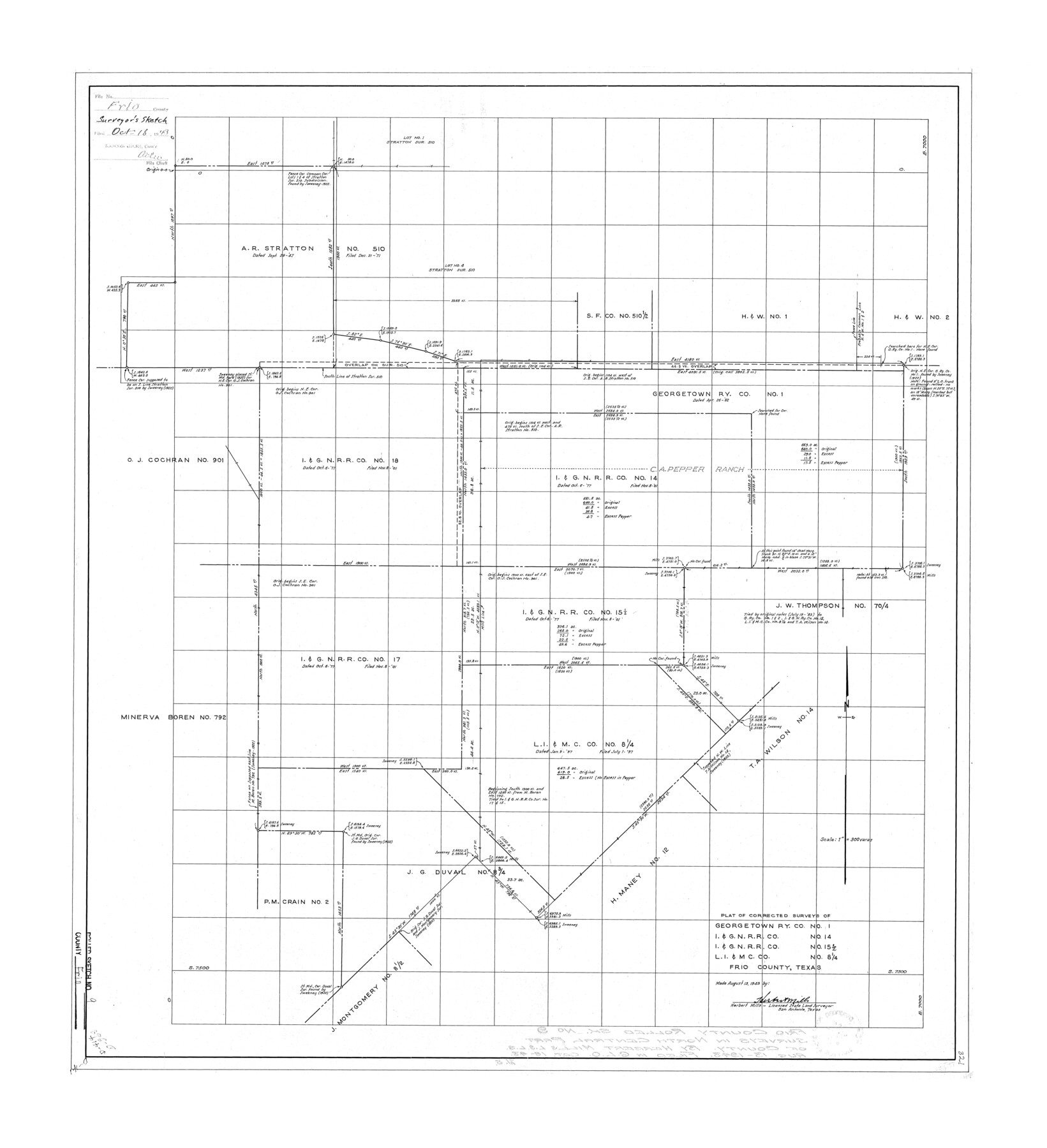
Frio County Rolled Sketch 9
Plat of corrected surveys of Georgetown Ry. Co. no. 1, I. & G. N. R.R. Co. no. 14, I. & G. N. R.R. Co. no. 15 1/2, and L. I. & M. C. Co. no. 8 1/4
-
Map/Doc
5919
-
Collection
General Map Collection
-
Object Dates
1943/8/13 (Creation Date)
1943/10/18 (File Date)
-
People and Organizations
Herbert Mills (Surveyor/Engineer)
-
Counties
Frio
-
Subjects
Surveying Rolled Sketch
-
Height x Width
35.7 x 32.5 inches
90.7 x 82.6 cm
-
Scale
1" = 300 varas
Part of: General Map Collection
Midland County Working Sketch 23

Print $40.00
- Digital $50.00
Midland County Working Sketch 23
1956
Size 45.0 x 75.6 inches
Map/Doc 71004
Swisher County Sketch File 11

Print $58.00
- Digital $50.00
Swisher County Sketch File 11
1917
Size 9.1 x 8.3 inches
Map/Doc 37633
Martin County Boundary File 62

Print $110.00
- Digital $50.00
Martin County Boundary File 62
Size 8.7 x 4.0 inches
Map/Doc 56782
Donley County Sketch File 5

Print $14.00
- Digital $50.00
Donley County Sketch File 5
Size 12.9 x 8.5 inches
Map/Doc 21223
Flight Mission No. BRA-3M, Frame 195, Jefferson County

Print $20.00
- Digital $50.00
Flight Mission No. BRA-3M, Frame 195, Jefferson County
1953
Size 18.6 x 22.3 inches
Map/Doc 85410
Reagan County Boundary File 1b

Print $38.00
- Digital $50.00
Reagan County Boundary File 1b
Size 9.3 x 8.3 inches
Map/Doc 58161
Harris County Working Sketch 16

Print $20.00
- Digital $50.00
Harris County Working Sketch 16
1916
Size 19.8 x 21.2 inches
Map/Doc 65908
Oldham County Sketch File 1

Print $24.00
- Digital $50.00
Oldham County Sketch File 1
1880
Size 12.6 x 7.9 inches
Map/Doc 33213
[Plat of All Surveys on Lavaca Not Heretofor Returned]
![283, [Plat of All Surveys on Lavaca Not Heretofor Returned], General Map Collection](https://historictexasmaps.com/wmedia_w700/maps/283.tif.jpg)
Print $20.00
- Digital $50.00
[Plat of All Surveys on Lavaca Not Heretofor Returned]
1841
Size 31.3 x 22.0 inches
Map/Doc 283
Parker County Working Sketch 2

Print $20.00
- Digital $50.00
Parker County Working Sketch 2
1920
Map/Doc 71452
Map of San Patricio County

Print $40.00
- Digital $50.00
Map of San Patricio County
1896
Size 29.1 x 48.7 inches
Map/Doc 1336
Howard County Boundary File 1

Print $51.00
- Digital $50.00
Howard County Boundary File 1
Size 14.4 x 8.8 inches
Map/Doc 55086
You may also like
Bee County Sketch File 25

Print $4.00
- Digital $50.00
Bee County Sketch File 25
1880
Size 11.0 x 8.2 inches
Map/Doc 14326

Bandera County Working Sketch 33

Print $20.00
- Digital $50.00
Bandera County Working Sketch 33
1961
Size 22.4 x 28.8 inches
Map/Doc 67629
Terrell County Working Sketch 46

Print $20.00
- Digital $50.00
Terrell County Working Sketch 46
1958
Size 23.8 x 23.4 inches
Map/Doc 62139
Dawson County Rolled Sketch 5

Print $20.00
- Digital $50.00
Dawson County Rolled Sketch 5
1913
Size 33.6 x 28.0 inches
Map/Doc 5691
Rusk County Sketch File 43

Print $20.00
Rusk County Sketch File 43
1951
Size 23.5 x 26.6 inches
Map/Doc 12278
The Republic County of Bexar. December 2, 1841

Print $20.00
The Republic County of Bexar. December 2, 1841
2020
Size 14.8 x 21.7 inches
Map/Doc 96098
Matagorda County Working Sketch 26

Print $20.00
- Digital $50.00
Matagorda County Working Sketch 26
1979
Size 14.1 x 19.5 inches
Map/Doc 70884
Throckmorton County Rolled Sketch 2

Print $20.00
- Digital $50.00
Throckmorton County Rolled Sketch 2
Size 28.9 x 36.3 inches
Map/Doc 7985
Ellis County Sketch File 3

Print $20.00
- Digital $50.00
Ellis County Sketch File 3
Size 23.6 x 28.0 inches
Map/Doc 11462
Liberty County Sketch File 10

Print $4.00
- Digital $50.00
Liberty County Sketch File 10
1858
Size 9.5 x 8.9 inches
Map/Doc 29903
Bexar County Working Sketch 16

Print $20.00
- Digital $50.00
Bexar County Working Sketch 16
1978
Size 23.0 x 44.5 inches
Map/Doc 67332