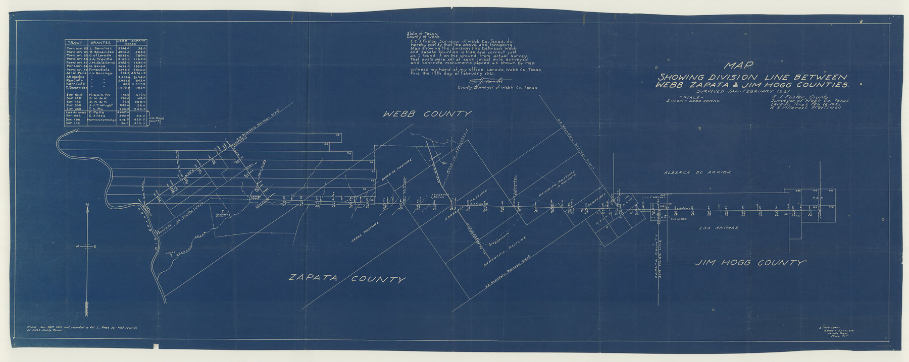
Webb County Boundary File 3b
[Correspondence regarding] Boundary line, Zapata and Webb Counties, Texas
-
Map/Doc
59758
-
Collection
General Map Collection
-
Counties
Webb
-
Subjects
County Boundaries
-
Height x Width
20.3 x 50.8 inches
51.6 x 129.0 cm
Part of: General Map Collection
Flight Mission No. CRC-2R, Frame 109, Chambers County

Print $20.00
- Digital $50.00
Flight Mission No. CRC-2R, Frame 109, Chambers County
1956
Size 18.6 x 22.3 inches
Map/Doc 84736
Lavaca County Working Sketch Graphic Index

Print $40.00
- Digital $50.00
Lavaca County Working Sketch Graphic Index
1946
Size 49.9 x 41.5 inches
Map/Doc 76616
Borden County Boundary File 5a

Print $98.00
- Digital $50.00
Borden County Boundary File 5a
Size 13.3 x 8.1 inches
Map/Doc 50659
Presidio County Working Sketch 62

Print $3.00
- Digital $50.00
Presidio County Working Sketch 62
1958
Size 12.6 x 9.5 inches
Map/Doc 71739
Armstrong County Rolled Sketch 4

Print $40.00
- Digital $50.00
Armstrong County Rolled Sketch 4
1876
Size 37.8 x 70.8 inches
Map/Doc 8426
Reeves County Working Sketch 59

Print $40.00
- Digital $50.00
Reeves County Working Sketch 59
1981
Size 36.3 x 72.8 inches
Map/Doc 63502
Flight Mission No. BRA-9M, Frame 65, Jefferson County

Print $20.00
- Digital $50.00
Flight Mission No. BRA-9M, Frame 65, Jefferson County
1953
Size 18.6 x 22.2 inches
Map/Doc 85648
Map of the City of Corsicana (Navarro County) Texas

Print $40.00
- Digital $50.00
Map of the City of Corsicana (Navarro County) Texas
1963
Size 43.2 x 92.3 inches
Map/Doc 93673

Map of the Texas & Pacific Railway from Fort Worth to El Paso

Print $40.00
- Digital $50.00
Map of the Texas & Pacific Railway from Fort Worth to El Paso
Size 24.0 x 76.5 inches
Map/Doc 64511
Galveston County Sketch File 27

Print $20.00
- Digital $50.00
Galveston County Sketch File 27
Size 18.3 x 30.0 inches
Map/Doc 11532
Reeves County Working Sketch 22

Print $20.00
- Digital $50.00
Reeves County Working Sketch 22
1966
Size 31.2 x 46.8 inches
Map/Doc 63465
You may also like
Flight Mission No. BRE-2P, Frame 12, Nueces County

Print $20.00
- Digital $50.00
Flight Mission No. BRE-2P, Frame 12, Nueces County
1956
Size 18.5 x 22.6 inches
Map/Doc 86721
Reeves County Sketch File 1a

Print $34.00
- Digital $50.00
Reeves County Sketch File 1a
Size 8.7 x 7.3 inches
Map/Doc 35181
Jim Wells County Working Sketch 6

Print $20.00
- Digital $50.00
Jim Wells County Working Sketch 6
1943
Size 33.3 x 21.2 inches
Map/Doc 66604
Hardin County Sketch File 46

Print $8.00
- Digital $50.00
Hardin County Sketch File 46
1875
Size 12.8 x 8.4 inches
Map/Doc 25196
Sketch Portion of Lamb County, Texas

Print $20.00
- Digital $50.00
Sketch Portion of Lamb County, Texas
1924
Size 19.9 x 21.4 inches
Map/Doc 92176
Presidio County Rolled Sketch 123

Print $40.00
- Digital $50.00
Presidio County Rolled Sketch 123
Size 49.3 x 38.2 inches
Map/Doc 9798
Edwards County Sketch File 35a

Print $20.00
- Digital $50.00
Edwards County Sketch File 35a
1928
Size 33.0 x 23.5 inches
Map/Doc 11435
Crosby County Rolled Sketch D2

Print $20.00
- Digital $50.00
Crosby County Rolled Sketch D2
Size 17.8 x 13.6 inches
Map/Doc 5644
Jefferson County Rolled Sketch 48A

Print $20.00
- Digital $50.00
Jefferson County Rolled Sketch 48A
1964
Size 28.4 x 28.1 inches
Map/Doc 6404
McMullen County Working Sketch 42

Print $20.00
- Digital $50.00
McMullen County Working Sketch 42
1980
Size 35.6 x 32.6 inches
Map/Doc 70743
La Salle County Working Sketch 2

Print $20.00
- Digital $50.00
La Salle County Working Sketch 2
1886
Size 17.6 x 16.0 inches
Map/Doc 70303
Maverick County Working Sketch 6

Print $40.00
- Digital $50.00
Maverick County Working Sketch 6
1944
Size 55.9 x 42.4 inches
Map/Doc 70898