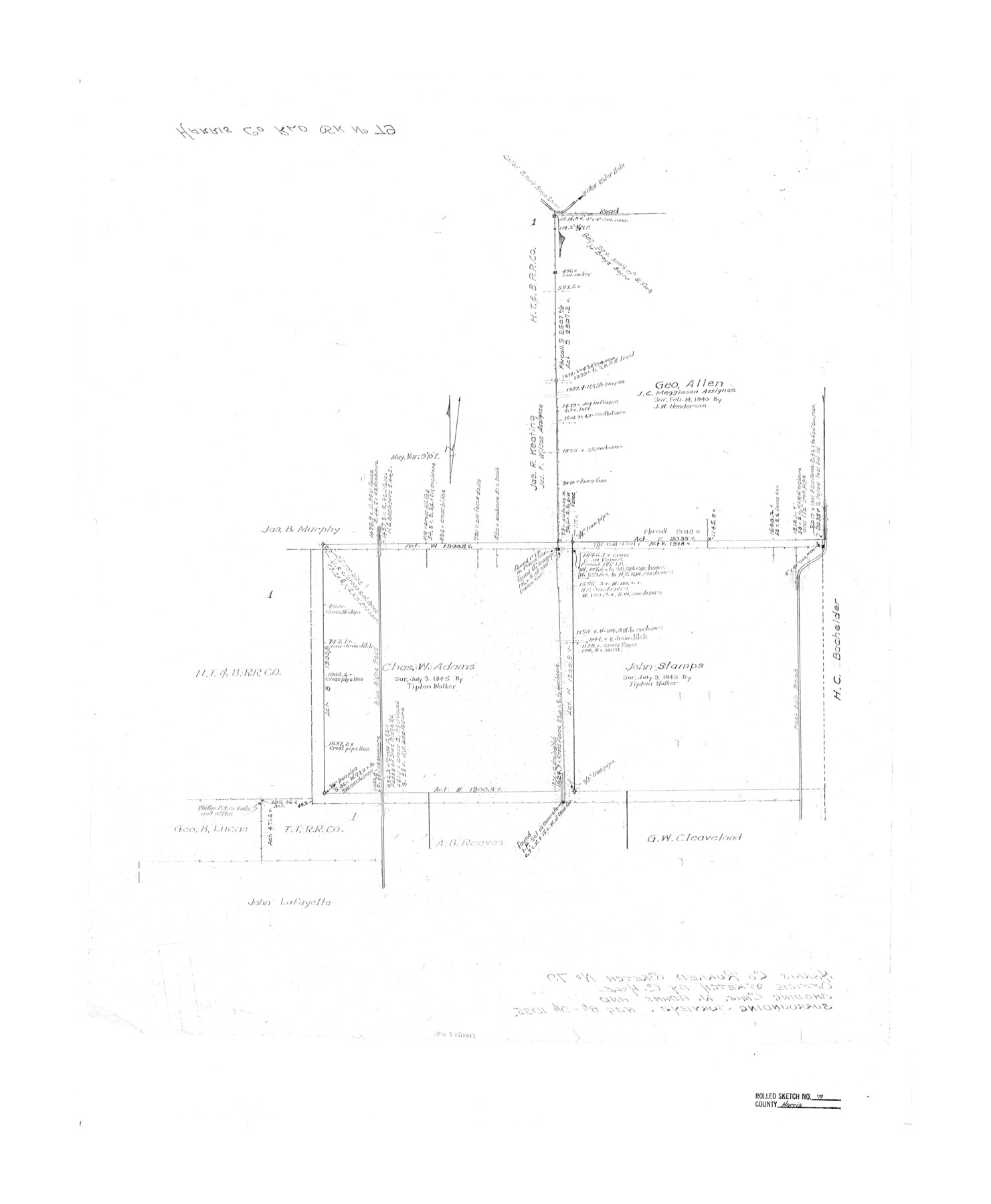
Harris County Rolled Sketch 79
[Office Sketch showing Chas. W. Adams and surrounding surveys, Harris County, Texas]
-
Map/Doc
6115
-
Collection
General Map Collection
-
Object Dates
1955/8/9 (Creation Date)
-
People and Organizations
C.R. Hale (Draftsman)
-
Counties
Harris
-
Subjects
Surveying Rolled Sketch
-
Height x Width
30.4 x 25.0 inches
77.2 x 63.5 cm
Part of: General Map Collection
Zapata County Boundary File 2

Print $12.00
- Digital $50.00
Zapata County Boundary File 2
Size 14.4 x 8.8 inches
Map/Doc 60228
Hunt County Sketch File 5a

Print $6.00
- Digital $50.00
Hunt County Sketch File 5a
1852
Size 10.2 x 15.8 inches
Map/Doc 27093
Fractional Township No. 8 South Range No. 12 East of the Indian Meridian, Indian Territory

Print $20.00
- Digital $50.00
Fractional Township No. 8 South Range No. 12 East of the Indian Meridian, Indian Territory
1896
Size 19.2 x 24.4 inches
Map/Doc 75223
Jackson County Aerial Photograph Index Sheet 6

Print $20.00
- Digital $50.00
Jackson County Aerial Photograph Index Sheet 6
1956
Size 21.2 x 15.7 inches
Map/Doc 83705
Val Verde County Sketch File 40A

Print $4.00
- Digital $50.00
Val Verde County Sketch File 40A
1939
Size 11.3 x 8.9 inches
Map/Doc 39307
Wichita County Boundary File 2a

Print $28.00
- Digital $50.00
Wichita County Boundary File 2a
Size 14.0 x 8.9 inches
Map/Doc 59906
Dominion of Canada and Newfoundland

Print $20.00
- Digital $50.00
Dominion of Canada and Newfoundland
1885
Size 12.2 x 9.0 inches
Map/Doc 93513
Erath County Working Sketch 52

Print $20.00
- Digital $50.00
Erath County Working Sketch 52
1992
Size 33.9 x 33.6 inches
Map/Doc 69134
Brazoria County Rolled Sketch 22

Print $20.00
- Digital $50.00
Brazoria County Rolled Sketch 22
1929
Size 28.1 x 40.8 inches
Map/Doc 10715
Bandera County Sketch File 6

Print $4.00
- Digital $50.00
Bandera County Sketch File 6
1877
Size 8.0 x 12.7 inches
Map/Doc 14005
Dimmit County Rolled Sketch 21

Print $20.00
- Digital $50.00
Dimmit County Rolled Sketch 21
2013
Size 25.5 x 22.5 inches
Map/Doc 93488

You may also like
Stonewall County Sketch File 15

Print $40.00
- Digital $50.00
Stonewall County Sketch File 15
1905
Size 14.3 x 8.7 inches
Map/Doc 37255
In the Supreme Court of the United States The State of Oklahoma, Complainant vs. The State of Texas, Defendant, The United States of America, Intervener - 1921

Print $40.00
- Digital $50.00
In the Supreme Court of the United States The State of Oklahoma, Complainant vs. The State of Texas, Defendant, The United States of America, Intervener - 1921
1921
Size 25.7 x 61.1 inches
Map/Doc 75127
Cooke County Sketch File 33

Print $44.00
- Digital $50.00
Cooke County Sketch File 33
1873
Size 13.4 x 26.5 inches
Map/Doc 11174
Palo Pinto County Boundary File 3

Print $58.00
- Digital $50.00
Palo Pinto County Boundary File 3
Size 14.3 x 8.7 inches
Map/Doc 57800
Presidio County Sketch File T

Print $10.00
- Digital $50.00
Presidio County Sketch File T
Size 13.1 x 8.8 inches
Map/Doc 34539
Donley County Rolled Sketch 3

Print $20.00
- Digital $50.00
Donley County Rolled Sketch 3
1946
Size 15.1 x 21.9 inches
Map/Doc 5729
Harris County Working Sketch Graphic Index, Sheet 2 (Sketches 69 to Most Recent)

Print $20.00
- Digital $50.00
Harris County Working Sketch Graphic Index, Sheet 2 (Sketches 69 to Most Recent)
1940
Size 38.5 x 46.2 inches
Map/Doc 76569
Flight Mission No. CGI-3N, Frame 175, Cameron County

Print $20.00
- Digital $50.00
Flight Mission No. CGI-3N, Frame 175, Cameron County
1954
Size 18.6 x 22.3 inches
Map/Doc 84639
Map of Callahan County

Print $20.00
- Digital $50.00
Map of Callahan County
1859
Size 24.5 x 19.4 inches
Map/Doc 3360
Texas, Copano Bay, Port Bay

Print $40.00
- Digital $50.00
Texas, Copano Bay, Port Bay
1934
Size 32.9 x 48.8 inches
Map/Doc 73432
[Surveys between Big Keechi Creek and the Trinity River]
![69753, [Surveys between Big Keechi Creek and the Trinity River], General Map Collection](https://historictexasmaps.com/wmedia_w700/maps/69753.tif.jpg)
Print $2.00
- Digital $50.00
[Surveys between Big Keechi Creek and the Trinity River]
Size 10.1 x 7.3 inches
Map/Doc 69753
Sutton County Working Sketch 50

Print $20.00
- Digital $50.00
Sutton County Working Sketch 50
1955
Size 27.4 x 22.2 inches
Map/Doc 62393