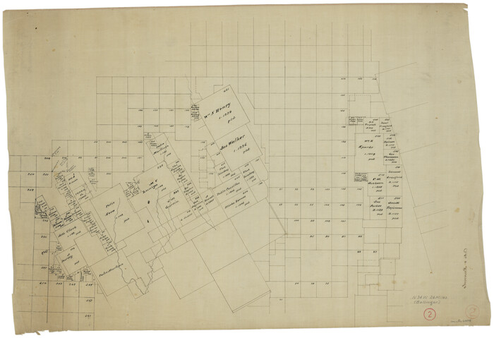
Presidio County Sketch File T
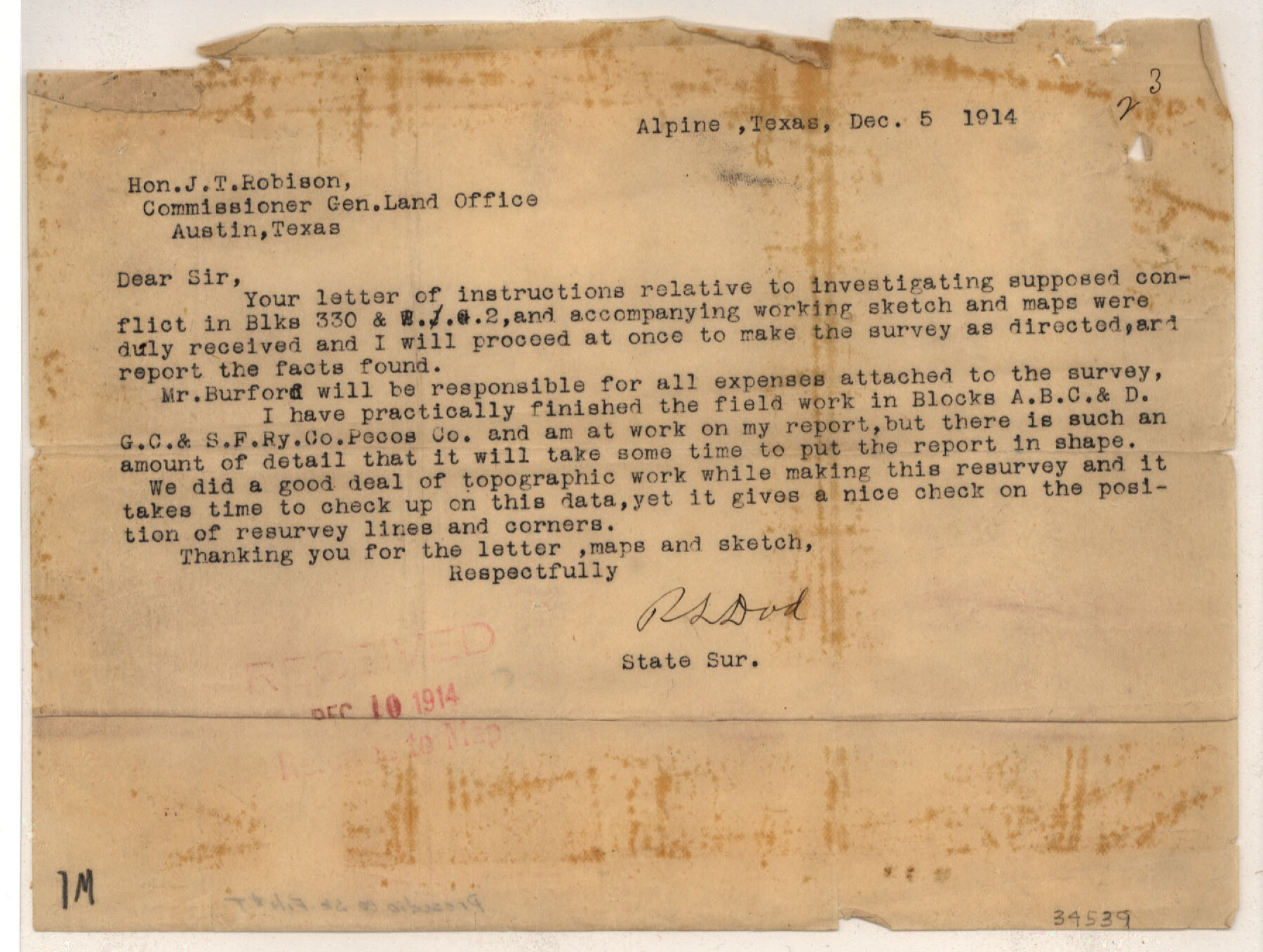
[Report of survey around Block 330]
-
Map/Doc
34539
-
Collection
General Map Collection
-
Object Dates
1/9/1915 (File Date)
12/5/1914 (Correspondence Date)
1/5/1915 (Correspondence Date)
-
People and Organizations
R.S. Dod (Surveyor/Engineer)
S.A. Thompson (Surveyor/Engineer)
Favors (Surveyor/Engineer)
W.S. Mabry (Surveyor/Engineer)
Marmion (Surveyor/Engineer)
Brooks (Surveyor/Engineer)
-
Counties
Presidio
-
Subjects
Surveying Sketch File
-
Height x Width
13.1 x 8.8 inches
33.3 x 22.4 cm
-
Medium
paper, print
-
Comments
See Presidio County Sketch File U (34544) and Presidio County Sketch File V (34549) for additional reports and correspondence, and see Presidio County Rolled Sketch 56 (7349), Presidio County Rolled Sketch 57 (7350), Presidio County Rolled Sketch 58 (7351), and Presidio County Rolled Sketch 59 (7352) for sketches.
-
Features
Cienega Creek
Las Moras Creek
Alamito Creek
St. Andrews Peak
Cathedral Peak
Cienega Ranch
Related maps
Presidio County Sketch File U

Print $10.00
- Digital $50.00
Presidio County Sketch File U
1914
Size 10.2 x 8.2 inches
Map/Doc 34544
Presidio County Sketch File V

Print $6.00
- Digital $50.00
Presidio County Sketch File V
1915
Size 11.2 x 8.8 inches
Map/Doc 34549
Presidio County Rolled Sketch 56

Print $20.00
- Digital $50.00
Presidio County Rolled Sketch 56
1915
Size 21.8 x 17.1 inches
Map/Doc 7349
Presidio County Rolled Sketch 57

Print $20.00
- Digital $50.00
Presidio County Rolled Sketch 57
1915
Size 22.8 x 17.3 inches
Map/Doc 7350
Presidio County Rolled Sketch 58

Print $20.00
- Digital $50.00
Presidio County Rolled Sketch 58
Size 26.1 x 36.6 inches
Map/Doc 7351
Presidio County Rolled Sketch 59

Print $20.00
- Digital $50.00
Presidio County Rolled Sketch 59
Size 27.6 x 18.2 inches
Map/Doc 7352
Part of: General Map Collection
Runnels County Working Sketch 2
Print $20.00
- Digital $50.00
Runnels County Working Sketch 2
Size 19.8 x 29.4 inches
Map/Doc 63598
Houston County Working Sketch 11

Print $20.00
- Digital $50.00
Houston County Working Sketch 11
1953
Size 28.5 x 24.5 inches
Map/Doc 66241
Archer County Working Sketch 19

Print $20.00
- Digital $50.00
Archer County Working Sketch 19
1960
Size 29.6 x 27.5 inches
Map/Doc 67160
Kleberg County Rolled Sketch 10-26

Print $20.00
- Digital $50.00
Kleberg County Rolled Sketch 10-26
1951
Size 36.6 x 35.5 inches
Map/Doc 9362
Map of Texas and Pacific Ry. Company's Surveys in the 80 Mile Reserve

Print $40.00
- Digital $50.00
Map of Texas and Pacific Ry. Company's Surveys in the 80 Mile Reserve
1885
Map/Doc 2241
Upton County Sketch File 7

Print $4.00
- Digital $50.00
Upton County Sketch File 7
Size 14.4 x 8.9 inches
Map/Doc 38820
Jim Wells County Working Sketch 13

Print $20.00
- Digital $50.00
Jim Wells County Working Sketch 13
1980
Size 36.7 x 26.3 inches
Map/Doc 66611
Flight Mission No. BRE-2P, Frame 123, Nueces County

Print $20.00
- Digital $50.00
Flight Mission No. BRE-2P, Frame 123, Nueces County
1956
Size 18.5 x 22.4 inches
Map/Doc 86799
Intracoastal Waterway, Houma, LA to Corpus Christi, TX

Print $20.00
- Digital $50.00
Intracoastal Waterway, Houma, LA to Corpus Christi, TX
Size 18.9 x 27.9 inches
Map/Doc 61906
West Part Presidio Co.

Print $20.00
- Digital $50.00
West Part Presidio Co.
1974
Size 43.2 x 34.3 inches
Map/Doc 95618
Flight Mission No. BRE-2P, Frame 110, Nueces County

Print $20.00
- Digital $50.00
Flight Mission No. BRE-2P, Frame 110, Nueces County
1956
Size 18.6 x 22.6 inches
Map/Doc 86796
[Right of Way & Track Map, The Texas & Pacific Ry. Co. Main Line]
![64688, [Right of Way & Track Map, The Texas & Pacific Ry. Co. Main Line], General Map Collection](https://historictexasmaps.com/wmedia_w700/maps/64688.tif.jpg)
Print $20.00
- Digital $50.00
[Right of Way & Track Map, The Texas & Pacific Ry. Co. Main Line]
Size 11.0 x 19.0 inches
Map/Doc 64688
You may also like
Denton County Sketch File 38

Print $26.00
- Digital $50.00
Denton County Sketch File 38
1934
Size 11.4 x 8.9 inches
Map/Doc 20778
Flight Mission No. DQN-1K, Frame 35, Calhoun County

Print $20.00
- Digital $50.00
Flight Mission No. DQN-1K, Frame 35, Calhoun County
1953
Size 18.5 x 19.0 inches
Map/Doc 84140
San Patricio County Rolled Sketch 47

Print $20.00
- Digital $50.00
San Patricio County Rolled Sketch 47
1939
Size 27.6 x 29.6 inches
Map/Doc 7731
Caldwell County Working Sketch Graphic Index

Print $20.00
- Digital $50.00
Caldwell County Working Sketch Graphic Index
1935
Size 36.7 x 41.3 inches
Map/Doc 76483
Lighthouse establishment on the Atlantic and Gulf Coasts and coast signal stations

Print $20.00
- Digital $50.00
Lighthouse establishment on the Atlantic and Gulf Coasts and coast signal stations
1898
Size 25.1 x 18.3 inches
Map/Doc 73051
Jasper County Sketch File 33

Print $20.00
- Digital $50.00
Jasper County Sketch File 33
1938
Size 23.0 x 17.6 inches
Map/Doc 11854
Reagan County Working Sketch 31

Print $20.00
- Digital $50.00
Reagan County Working Sketch 31
1964
Size 38.7 x 36.6 inches
Map/Doc 71873
Reeves County Working Sketch 58

Print $20.00
- Digital $50.00
Reeves County Working Sketch 58
1980
Size 32.3 x 25.3 inches
Map/Doc 63501
Hudspeth County Working Sketch 52

Print $20.00
- Digital $50.00
Hudspeth County Working Sketch 52
1985
Size 29.8 x 36.6 inches
Map/Doc 66337
Mineral Locality Map of Texas Showing Occurances of Useful Minerals, Rocks, Oil and Gas, and Other Geologic Substances

Print $40.00
- Digital $50.00
Mineral Locality Map of Texas Showing Occurances of Useful Minerals, Rocks, Oil and Gas, and Other Geologic Substances
1945
Size 43.8 x 53.0 inches
Map/Doc 94140
Slaton-Tex Sewer System

Print $20.00
- Digital $50.00
Slaton-Tex Sewer System
1922
Size 44.3 x 30.6 inches
Map/Doc 92819
Kendall County Sketch File 29

Print $14.00
- Digital $50.00
Kendall County Sketch File 29
1990
Size 14.0 x 8.5 inches
Map/Doc 95291