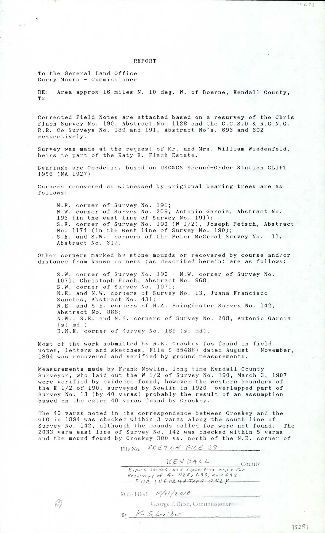
Kendall County Sketch File 29
Report, sketch, and supporting documents for resurveys of A-1128, A-693 and A-692
-
Map/Doc
95291
-
Collection
General Map Collection
-
Object Dates
7/11/1990 (Creation Date)
10/1/2018 (File Date)
8/1894 (Survey Date)
11/1894 (Survey Date)
3/3/1907 (Survey Date)
1920 (Survey Date)
-
People and Organizations
Charles Ottmers (Surveyor/Engineer)
R.K. Croskey (Surveyor/Engineer)
Frank Nowlin (Surveyor/Engineer)
-
Counties
Kendall
-
Subjects
Surveying Sketch File
-
Height x Width
14.0 x 8.5 inches
35.6 x 21.6 cm
-
Medium
multi-page, multi-format
-
Comments
Filed for information only. For plat, see Kendall County Rolled Sketch 9 (95298)
-
Features
Dunners Mountain
Darmstadt Creek
Polecat Creek
Schleicher Mountain
Los Ricos Pobres Ranch Subdivision
Upper Sisterdale County Road
Related maps
Kendall County Rolled Sketch 9

Print $20.00
- Digital $50.00
Kendall County Rolled Sketch 9
1990
Size 32.8 x 24.3 inches
Map/Doc 95298
Part of: General Map Collection
Gonzales County Sketch File 6

Print $4.00
- Digital $50.00
Gonzales County Sketch File 6
1880
Size 10.2 x 8.7 inches
Map/Doc 24385
Anderson County Sketch File 15a

Print $4.00
- Digital $50.00
Anderson County Sketch File 15a
1859
Size 14.5 x 8.0 inches
Map/Doc 12781
Borden County Sketch File 3

Print $4.00
- Digital $50.00
Borden County Sketch File 3
1902
Size 7.3 x 12.8 inches
Map/Doc 14703
El Paso County Sketch File 17

Print $20.00
- Digital $50.00
El Paso County Sketch File 17
1885
Size 20.1 x 30.9 inches
Map/Doc 11453
Ward County Working Sketch 45

Print $40.00
- Digital $50.00
Ward County Working Sketch 45
1973
Size 56.8 x 28.3 inches
Map/Doc 72351
Map of the Southwestern and part of the Western States to illustrate Olney's school geography

Print $20.00
- Digital $50.00
Map of the Southwestern and part of the Western States to illustrate Olney's school geography
1844
Size 19.0 x 12.1 inches
Map/Doc 93541
Newton County Working Sketch 1

Print $20.00
- Digital $50.00
Newton County Working Sketch 1
Size 25.5 x 25.9 inches
Map/Doc 71247
Pecos County Sketch File 53

Print $20.00
- Digital $50.00
Pecos County Sketch File 53
Size 18.0 x 38.9 inches
Map/Doc 10569
Surveys in Austin's Colony along the Colorado River below the San Antonio Road

Print $20.00
- Digital $50.00
Surveys in Austin's Colony along the Colorado River below the San Antonio Road
1830
Size 38.2 x 13.5 inches
Map/Doc 193
Flight Mission No. DAG-23K, Frame 60, Matagorda County

Print $20.00
- Digital $50.00
Flight Mission No. DAG-23K, Frame 60, Matagorda County
1953
Size 15.8 x 15.8 inches
Map/Doc 86487
Map of Potter County

Print $20.00
- Digital $50.00
Map of Potter County
1895
Size 27.0 x 21.1 inches
Map/Doc 3966
Montague County Working Sketch 25

Print $20.00
- Digital $50.00
Montague County Working Sketch 25
1955
Size 42.4 x 28.4 inches
Map/Doc 71091
You may also like
Chambers County Rolled Sketch 26

Print $20.00
- Digital $50.00
Chambers County Rolled Sketch 26
1947
Size 12.7 x 19.9 inches
Map/Doc 5428
Kimble County Working Sketch 94

Print $20.00
- Digital $50.00
Kimble County Working Sketch 94
1993
Size 28.3 x 33.7 inches
Map/Doc 70162
[Missouri, Kansas & Texas Line Map through Bastrop County]
![64032, [Missouri, Kansas & Texas Line Map through Bastrop County], General Map Collection](https://historictexasmaps.com/wmedia_w700/maps/64032.tif.jpg)
Print $40.00
- Digital $50.00
[Missouri, Kansas & Texas Line Map through Bastrop County]
1916
Size 25.4 x 106.0 inches
Map/Doc 64032
Hardeman County

Print $20.00
- Digital $50.00
Hardeman County
1935
Size 44.4 x 41.4 inches
Map/Doc 73170
Cottle County Rolled Sketch 14

Print $741.00
- Digital $50.00
Cottle County Rolled Sketch 14
1882
Size 10.8 x 16.0 inches
Map/Doc 42369
Haskell County Working Sketch 4

Print $20.00
- Digital $50.00
Haskell County Working Sketch 4
1938
Size 30.4 x 26.9 inches
Map/Doc 66062
Midland County Rolled Sketch 12

Print $40.00
- Digital $50.00
Midland County Rolled Sketch 12
Size 97.0 x 42.6 inches
Map/Doc 9520
Childress Co.

Print $20.00
- Digital $50.00
Childress Co.
1978
Size 44.6 x 33.7 inches
Map/Doc 77237
McMullen County Rolled Sketch 15

Print $20.00
- Digital $50.00
McMullen County Rolled Sketch 15
1948
Size 30.9 x 25.9 inches
Map/Doc 6732
Scurry County Working Sketch 7

Print $20.00
- Digital $50.00
Scurry County Working Sketch 7
1971
Size 33.5 x 29.0 inches
Map/Doc 63836
Kimble County Rolled Sketch 33

Print $20.00
- Digital $50.00
Kimble County Rolled Sketch 33
1973
Size 26.7 x 20.1 inches
Map/Doc 6523
Guadalupe County Sketch File 20

Print $6.00
- Digital $50.00
Guadalupe County Sketch File 20
1912
Size 11.1 x 8.7 inches
Map/Doc 24699