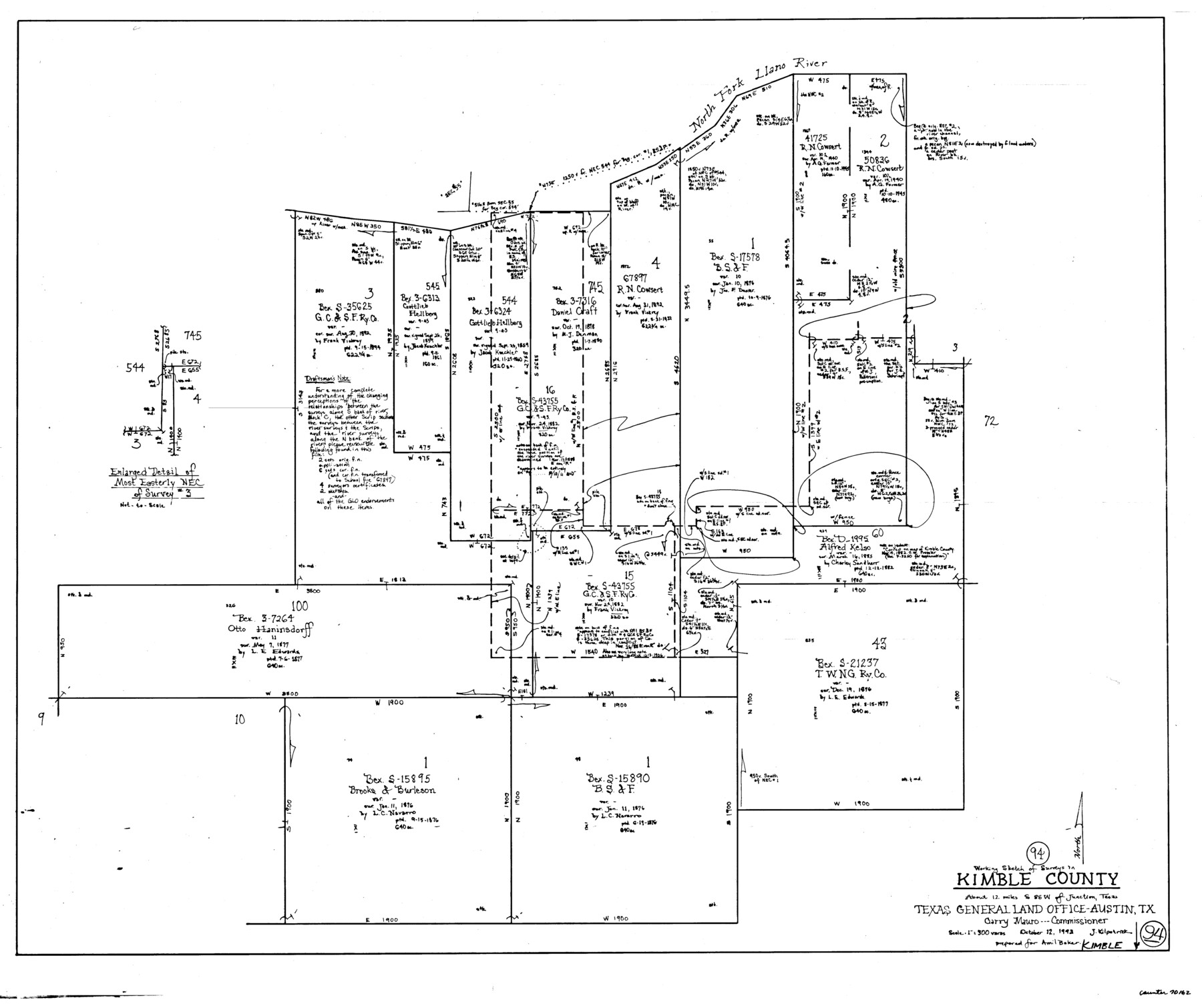
Kimble County Working Sketch 94
-
Map/Doc
70162
-
Collection
General Map Collection
-
Object Dates
10/12/1993 (Creation Date)
-
People and Organizations
Joan Kilpatrick (Draftsman)
-
Counties
Kimble
-
Subjects
Surveying Working Sketch
-
Height x Width
28.3 x 33.7 inches
71.9 x 85.6 cm
-
Scale
1" = 300 varas
Part of: General Map Collection
Flight Mission No. DAG-24K, Frame 47, Matagorda County

Print $20.00
- Digital $50.00
Flight Mission No. DAG-24K, Frame 47, Matagorda County
1953
Size 18.5 x 22.3 inches
Map/Doc 86534
The Military History of Texas Map!

The Military History of Texas Map!
1996
Size 24.2 x 35.0 inches
Map/Doc 96828
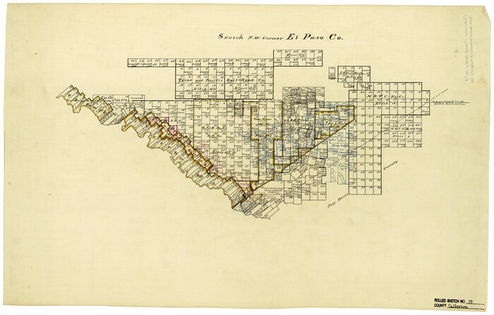
Culberson County Rolled Sketch 19
Print $20.00
- Digital $50.00
Culberson County Rolled Sketch 19
Size 18.8 x 29.4 inches
Map/Doc 5651
San Patricio County Working Sketch 15

Print $20.00
- Digital $50.00
San Patricio County Working Sketch 15
1951
Size 20.9 x 25.6 inches
Map/Doc 63777
Zavala County Working Sketch 19

Print $40.00
- Digital $50.00
Zavala County Working Sketch 19
1978
Size 16.2 x 59.1 inches
Map/Doc 62094
Ward County Working Sketch 6

Print $20.00
- Digital $50.00
Ward County Working Sketch 6
1945
Size 23.4 x 24.5 inches
Map/Doc 72312
Map of Robertson County

Print $20.00
- Digital $50.00
Map of Robertson County
1873
Size 28.0 x 21.6 inches
Map/Doc 83003
Maverick County Rolled Sketch 20

Print $20.00
- Digital $50.00
Maverick County Rolled Sketch 20
Size 24.5 x 38.7 inches
Map/Doc 6712
Southern Part of Laguna Madre

Print $20.00
- Digital $50.00
Southern Part of Laguna Madre
1987
Size 44.5 x 34.7 inches
Map/Doc 73548
Brazoria County Working Sketch 40

Print $3.00
- Digital $50.00
Brazoria County Working Sketch 40
1982
Size 11.0 x 10.8 inches
Map/Doc 67525
Armstrong County, State of Texas

Print $20.00
- Digital $50.00
Armstrong County, State of Texas
1888
Size 22.6 x 18.2 inches
Map/Doc 3245
Madison County Working Sketch 3

Print $20.00
- Digital $50.00
Madison County Working Sketch 3
1945
Size 29.3 x 21.6 inches
Map/Doc 70765
You may also like
Wichita County Working Sketch 12a

Print $20.00
- Digital $50.00
Wichita County Working Sketch 12a
1920
Size 20.2 x 14.1 inches
Map/Doc 72521
Edwards County Working Sketch 99

Print $20.00
- Digital $50.00
Edwards County Working Sketch 99
1970
Size 36.3 x 27.9 inches
Map/Doc 68975
Eastland County Rolled Sketch 26

Print $20.00
- Digital $50.00
Eastland County Rolled Sketch 26
1918
Size 23.2 x 17.9 inches
Map/Doc 5777
Concho County Working Sketch 15

Print $20.00
- Digital $50.00
Concho County Working Sketch 15
1955
Size 25.2 x 30.8 inches
Map/Doc 68197
Flight Mission No. DCL-5C, Frame 68, Kenedy County

Print $20.00
- Digital $50.00
Flight Mission No. DCL-5C, Frame 68, Kenedy County
1943
Size 18.6 x 22.4 inches
Map/Doc 85851
The Republic County of Austin. Proposed, Fall 1837-May 23, 1838

Print $20.00
The Republic County of Austin. Proposed, Fall 1837-May 23, 1838
2020
Size 14.8 x 21.7 inches
Map/Doc 96081
Hemphill County Working Sketch 1

Print $20.00
- Digital $50.00
Hemphill County Working Sketch 1
1926
Size 15.1 x 19.7 inches
Map/Doc 66096
Young County Working Sketch 10

Print $20.00
- Digital $50.00
Young County Working Sketch 10
1921
Size 24.4 x 34.4 inches
Map/Doc 62033
Newton County Working Sketch 29

Print $20.00
- Digital $50.00
Newton County Working Sketch 29
1955
Size 21.2 x 39.8 inches
Map/Doc 71275
Topographical Map of the Rio Grande, Sheet No. 19

Print $20.00
- Digital $50.00
Topographical Map of the Rio Grande, Sheet No. 19
1912
Map/Doc 89543

Map of North America designed to accompany Smith's Geography for Schools

Print $20.00
- Digital $50.00
Map of North America designed to accompany Smith's Geography for Schools
1850
Size 12.0 x 9.9 inches
Map/Doc 93883