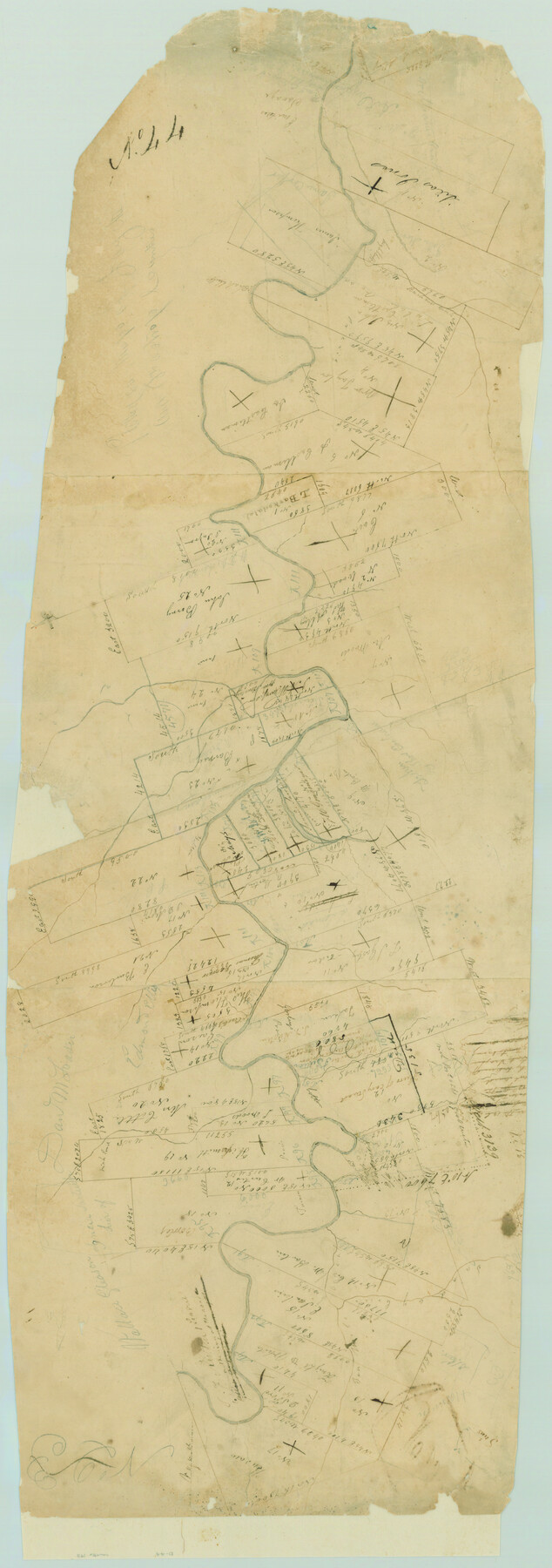
Surveys in Austin's Colony along the Colorado River below the San Antonio Road
Atlas D, Sketch 44 (D-44)
D-44
-
Map/Doc
193
-
Collection
General Map Collection
-
Object Dates
1830 (Creation Date)
-
People and Organizations
Thomas H. Borden (Surveyor/Engineer)
-
Counties
Bastrop Fayette
-
Subjects
Atlas
-
Height x Width
38.2 x 13.5 inches
97.0 x 34.3 cm
-
Medium
paper, manuscript
-
Scale
No scale given
-
Comments
Conserved in 2004.
-
Features
Williams Creek
Buckness Creek
Ten Mile Creek
Sunday Creek
Part of: General Map Collection
Flight Mission No. DIX-7P, Frame 91, Aransas County

Print $20.00
- Digital $50.00
Flight Mission No. DIX-7P, Frame 91, Aransas County
1956
Size 18.7 x 22.4 inches
Map/Doc 83885
Mitchell County Boundary File 66a

Print $11.00
- Digital $50.00
Mitchell County Boundary File 66a
Size 12.6 x 8.3 inches
Map/Doc 57378
Rockwall County Boundary File 6

Print $48.00
- Digital $50.00
Rockwall County Boundary File 6
Size 14.0 x 8.6 inches
Map/Doc 58420
Chambers County Working Sketch 14

Print $20.00
- Digital $50.00
Chambers County Working Sketch 14
1957
Size 30.3 x 19.0 inches
Map/Doc 67997
Harris County State Real Property Sketch 3

Print $42.00
- Digital $50.00
Harris County State Real Property Sketch 3
2004
Size 24.9 x 36.9 inches
Map/Doc 81952
Cass County Working Sketch 6

Print $20.00
- Digital $50.00
Cass County Working Sketch 6
1936
Size 19.7 x 23.0 inches
Map/Doc 67909
Crockett County Working Sketch 61

Print $20.00
- Digital $50.00
Crockett County Working Sketch 61
1955
Size 36.5 x 33.2 inches
Map/Doc 68394
Intracoastal Waterway in Texas - Corpus Christi to Point Isabel including Arroyo Colorado to Mo. Pac. R.R. Bridge Near Harlingen

Print $20.00
- Digital $50.00
Intracoastal Waterway in Texas - Corpus Christi to Point Isabel including Arroyo Colorado to Mo. Pac. R.R. Bridge Near Harlingen
1933
Size 28.2 x 41.0 inches
Map/Doc 61846
Reeves County Working Sketch 37

Print $40.00
- Digital $50.00
Reeves County Working Sketch 37
1971
Size 57.7 x 36.7 inches
Map/Doc 63480
Flight Mission No. DIX-6P, Frame 197, Aransas County

Print $20.00
- Digital $50.00
Flight Mission No. DIX-6P, Frame 197, Aransas County
1956
Size 19.1 x 22.8 inches
Map/Doc 83859
Culberson County Working Sketch 28

Print $40.00
- Digital $50.00
Culberson County Working Sketch 28
1952
Size 51.3 x 38.9 inches
Map/Doc 68481
Culberson County Working Sketch 7

Print $20.00
- Digital $50.00
Culberson County Working Sketch 7
1912
Size 21.2 x 17.7 inches
Map/Doc 68459
You may also like
Map of Webb County

Print $20.00
- Digital $50.00
Map of Webb County
1895
Size 34.8 x 27.0 inches
Map/Doc 4132

Sketch in Crockett County [showing University Land Blocks 46-51]
![90312, Sketch in Crockett County [showing University Land Blocks 46-51], Twichell Survey Records](https://historictexasmaps.com/wmedia_w700/maps/90312-1.tif.jpg)
Print $20.00
- Digital $50.00
Sketch in Crockett County [showing University Land Blocks 46-51]
1915
Size 10.6 x 20.1 inches
Map/Doc 90312
Matagorda County Working Sketch 29

Print $20.00
- Digital $50.00
Matagorda County Working Sketch 29
1981
Size 35.6 x 34.0 inches
Map/Doc 70887
Schleicher County Sketch File 36

Print $20.00
- Digital $50.00
Schleicher County Sketch File 36
1951
Size 15.2 x 21.7 inches
Map/Doc 12309
Map of the World on Mercator's Projection, flags of all nations and cities of the United States

Print $40.00
- Digital $50.00
Map of the World on Mercator's Projection, flags of all nations and cities of the United States
1874
Size 40.4 x 55.6 inches
Map/Doc 93914
Foard County Working Sketch 12

Print $20.00
- Digital $50.00
Foard County Working Sketch 12
1977
Size 43.4 x 36.1 inches
Map/Doc 69203
Flight Mission No. DQO-7K, Frame 111, Galveston County

Print $20.00
- Digital $50.00
Flight Mission No. DQO-7K, Frame 111, Galveston County
1952
Size 18.7 x 22.4 inches
Map/Doc 85126
Coast Chart No. 210 - Aransas Pass and Corpus Christi Bay with the coast to latitude 27° 12', Texas

Print $20.00
- Digital $50.00
Coast Chart No. 210 - Aransas Pass and Corpus Christi Bay with the coast to latitude 27° 12', Texas
1887
Size 18.1 x 23.8 inches
Map/Doc 73446
Current Miscellaneous File 15

Print $16.00
- Digital $50.00
Current Miscellaneous File 15
1951
Size 10.7 x 8.2 inches
Map/Doc 73822
Stonewall County Sketch File 31

Print $77.00
- Digital $50.00
Stonewall County Sketch File 31
2001
Size 11.3 x 8.9 inches
Map/Doc 37308
Van Zandt County Sketch File 42

Print $4.00
- Digital $50.00
Van Zandt County Sketch File 42
1874
Size 10.0 x 8.1 inches
Map/Doc 39495