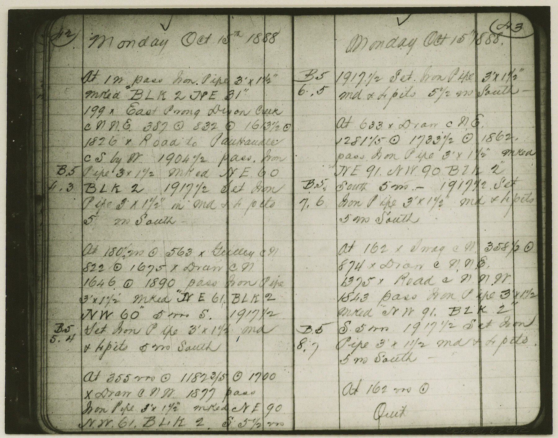
Copy of Surveyor's Field Book, Morris Browning - In Blocks 7, 5 & 4, I&GNRRCo., Hutchinson and Carson Counties, Texas
K-7-70
-
Map/Doc
62282
-
Collection
General Map Collection
-
Object Dates
1888/10/22 (Creation Date)
-
People and Organizations
Morris Browning (Surveyor/Engineer)
-
Counties
Hutchinson Carson
-
Height x Width
6.9 x 8.8 inches
17.5 x 22.4 cm
-
Comments
Copy of Surveyor's field book presented to the General Land Office by Morris Browning on February 3, 1941.
Surveyed from September 14, 1888 to October 22, 1888.
Part of: General Map Collection
Kinney County Sketch File 14

Print $6.00
- Digital $50.00
Kinney County Sketch File 14
1886
Size 10.9 x 16.6 inches
Map/Doc 29131

Hood County Working Sketch 29

Print $20.00
- Digital $50.00
Hood County Working Sketch 29
1934
Size 21.5 x 25.0 inches
Map/Doc 66223
Starr County Rolled Sketch 30

Print $20.00
- Digital $50.00
Starr County Rolled Sketch 30
1941
Size 14.9 x 21.5 inches
Map/Doc 7813
Llano County Sketch File 6

Print $8.00
- Digital $50.00
Llano County Sketch File 6
1877
Size 9.4 x 7.9 inches
Map/Doc 30358
Crockett County Working Sketch 78

Print $40.00
- Digital $50.00
Crockett County Working Sketch 78
1972
Size 48.3 x 36.0 inches
Map/Doc 68411
Tarrant County Working Sketch 20

Print $20.00
- Digital $50.00
Tarrant County Working Sketch 20
1999
Size 15.4 x 16.8 inches
Map/Doc 62437
Zapata County Rolled Sketch 4

Print $20.00
- Digital $50.00
Zapata County Rolled Sketch 4
1884
Size 15.6 x 13.8 inches
Map/Doc 8306
[Sketch for Mineral Application 26501 - Sabine River, T. A. Oldhausen]
![2842, [Sketch for Mineral Application 26501 - Sabine River, T. A. Oldhausen], General Map Collection](https://historictexasmaps.com/wmedia_w700/maps/2842.tif.jpg)
Print $20.00
- Digital $50.00
[Sketch for Mineral Application 26501 - Sabine River, T. A. Oldhausen]
1931
Size 24.0 x 36.9 inches
Map/Doc 2842
Nueces County Rolled Sketch 43A

Print $20.00
- Digital $50.00
Nueces County Rolled Sketch 43A
Size 24.0 x 35.4 inches
Map/Doc 6884
Galveston County Rolled Sketch 22

Print $20.00
- Digital $50.00
Galveston County Rolled Sketch 22
1953
Size 29.6 x 40.8 inches
Map/Doc 9083
Reeves County Boundary File 81 1/2

Print $54.00
- Digital $50.00
Reeves County Boundary File 81 1/2
Size 9.7 x 8.3 inches
Map/Doc 58216
You may also like
Reagan County Working Sketch 37

Print $20.00
- Digital $50.00
Reagan County Working Sketch 37
1966
Size 34.3 x 45.1 inches
Map/Doc 71879
Bell County Rolled Sketch 1

Print $20.00
- Digital $50.00
Bell County Rolled Sketch 1
1954
Size 38.1 x 41.1 inches
Map/Doc 75938
General Highway Map, Garza County, Texas

Print $20.00
General Highway Map, Garza County, Texas
1961
Size 18.2 x 24.6 inches
Map/Doc 79478
Hudspeth County Rolled Sketch 25

Print $20.00
- Digital $50.00
Hudspeth County Rolled Sketch 25
1909
Size 18.0 x 20.7 inches
Map/Doc 6245
Flight Mission No. DQN-6K, Frame 13, Calhoun County

Print $20.00
- Digital $50.00
Flight Mission No. DQN-6K, Frame 13, Calhoun County
1953
Size 18.5 x 22.2 inches
Map/Doc 84435
Public Land on Mustang Island, Nueces County

Print $20.00
- Digital $50.00
Public Land on Mustang Island, Nueces County
1945
Size 43.4 x 40.1 inches
Map/Doc 73335
Map Showing Lands Owned by Capitol Freehold Land and Investment Company, Ltd.

Print $20.00
- Digital $50.00
Map Showing Lands Owned by Capitol Freehold Land and Investment Company, Ltd.
1909
Size 36.4 x 25.2 inches
Map/Doc 90733
[Blocks D3 and GP]
![91506, [Blocks D3 and GP], Twichell Survey Records](https://historictexasmaps.com/wmedia_w700/maps/91506-1.tif.jpg)
Print $20.00
- Digital $50.00
[Blocks D3 and GP]
Size 18.2 x 19.3 inches
Map/Doc 91506
Map of the Aransas Pass Transit Railway

Print $40.00
- Digital $50.00
Map of the Aransas Pass Transit Railway
1890
Size 23.9 x 60.9 inches
Map/Doc 64369
Presidio County Rolled Sketch 74

Print $20.00
- Digital $50.00
Presidio County Rolled Sketch 74
Size 20.5 x 14.0 inches
Map/Doc 7362
Map of the District of San Patricio and Nueces

Print $40.00
- Digital $50.00
Map of the District of San Patricio and Nueces
Size 93.8 x 67.5 inches
Map/Doc 1955
Harris County Rolled Sketch 26

Print $20.00
- Digital $50.00
Harris County Rolled Sketch 26
Size 28.2 x 41.3 inches
Map/Doc 6094