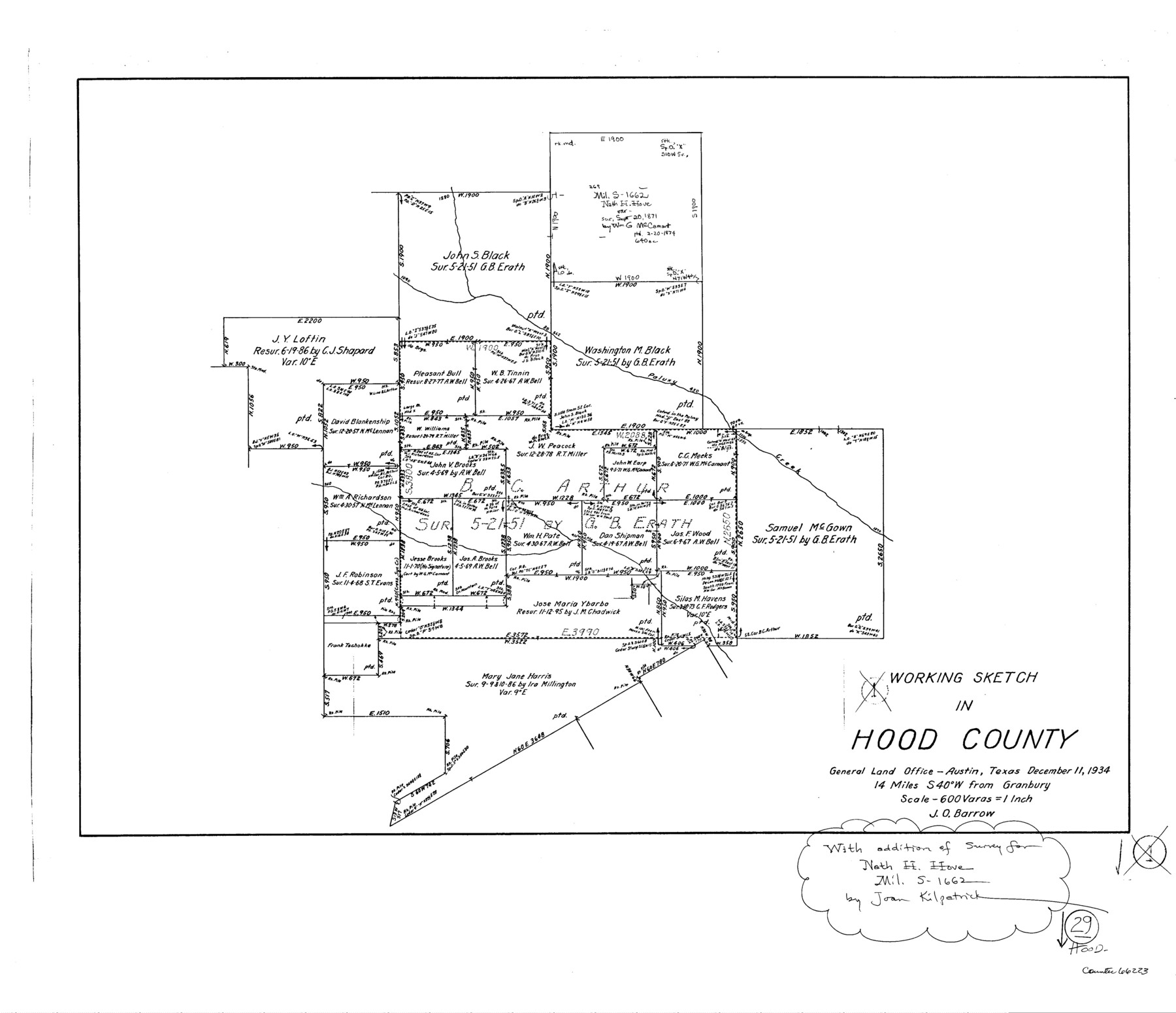
Hood County Working Sketch 29
-
Map/Doc
66223
-
Collection
General Map Collection
-
Object Dates
12/11/1934 (Creation Date)
-
People and Organizations
J.O. Barrow (Draftsman)
Joan Kilpatrick (Draftsman)
-
Counties
Hood
-
Subjects
Surveying Working Sketch
-
Height x Width
21.5 x 25.0 inches
54.6 x 63.5 cm
-
Scale
1" = 600 varas
Part of: General Map Collection
[Location Survey of the Southern Kansas Railway, Kiowa Extension from a point in Drake's Location, in Indian Territory 100 miles from south line of Kansas, continuing up Wolf Creek and South Canadian River to Cottonwood Creek in Hutchinson County]
![88839, [Location Survey of the Southern Kansas Railway, Kiowa Extension from a point in Drake's Location, in Indian Territory 100 miles from south line of Kansas, continuing up Wolf Creek and South Canadian River to Cottonwood Creek in Hutchinson County], General Map Collection](https://historictexasmaps.com/wmedia_w700/maps/88839.tif.jpg)
Print $20.00
- Digital $50.00
[Location Survey of the Southern Kansas Railway, Kiowa Extension from a point in Drake's Location, in Indian Territory 100 miles from south line of Kansas, continuing up Wolf Creek and South Canadian River to Cottonwood Creek in Hutchinson County]
1886
Size 38.9 x 36.0 inches
Map/Doc 88839
Reagan County Working Sketch 13

Print $40.00
- Digital $50.00
Reagan County Working Sketch 13
1948
Size 23.8 x 50.8 inches
Map/Doc 71853
Donley County Working Sketch 5

Print $40.00
- Digital $50.00
Donley County Working Sketch 5
1957
Size 54.8 x 32.2 inches
Map/Doc 62185
Map of Webb County

Print $20.00
- Digital $50.00
Map of Webb County
1895
Size 34.8 x 27.0 inches
Map/Doc 4132
Kleberg County Sketch File 2

Print $5.00
- Digital $50.00
Kleberg County Sketch File 2
1934
Size 11.1 x 8.8 inches
Map/Doc 29210
Liberty County Sketch File 57

Print $40.00
- Digital $50.00
Liberty County Sketch File 57
1928
Size 55.1 x 17.4 inches
Map/Doc 10523
Galveston County NRC Article 33.136 Sketch 88

Print $42.00
- Digital $50.00
Galveston County NRC Article 33.136 Sketch 88
2019
Size 24.6 x 36.3 inches
Map/Doc 95735
Johnson County Working Sketch 12

Print $20.00
- Digital $50.00
Johnson County Working Sketch 12
1959
Size 22.9 x 22.6 inches
Map/Doc 66625
Sterling County Sketch File 3

Print $20.00
- Digital $50.00
Sterling County Sketch File 3
Size 14.5 x 34.8 inches
Map/Doc 12355
Terrell County Working Sketch 80

Print $20.00
- Digital $50.00
Terrell County Working Sketch 80
1985
Size 20.7 x 36.4 inches
Map/Doc 69601
Nueces County Navigation District Number One, Submerged Lands Maintained for Navigational Purposes Persuant to Sub-Section G of Section 61.117 Texas Water Code

Print $20.00
- Digital $50.00
Nueces County Navigation District Number One, Submerged Lands Maintained for Navigational Purposes Persuant to Sub-Section G of Section 61.117 Texas Water Code
1975
Size 23.3 x 29.9 inches
Map/Doc 61806
Travis County Rolled Sketch 59

Print $20.00
- Digital $50.00
Travis County Rolled Sketch 59
1987
Size 17.0 x 22.6 inches
Map/Doc 8050
You may also like
Crosby County Sketch File 11a

Print $10.00
- Digital $50.00
Crosby County Sketch File 11a
1894
Size 8.7 x 4.4 inches
Map/Doc 20029
Current Miscellaneous File 89

Print $4.00
- Digital $50.00
Current Miscellaneous File 89
Size 12.1 x 8.9 inches
Map/Doc 74253
Shackelford County Sketch File 1

Print $4.00
- Digital $50.00
Shackelford County Sketch File 1
1877
Size 12.8 x 8.0 inches
Map/Doc 36570
Hudspeth County Rolled Sketch 32

Print $40.00
- Digital $50.00
Hudspeth County Rolled Sketch 32
Size 32.7 x 94.9 inches
Map/Doc 9211
Nueces County Aerial Photograph Index Sheet 5

Print $20.00
- Digital $50.00
Nueces County Aerial Photograph Index Sheet 5
1956
Size 19.5 x 23.4 inches
Map/Doc 83738
General Highway Map, Trinity County, Texas

Print $20.00
General Highway Map, Trinity County, Texas
1961
Size 18.1 x 24.5 inches
Map/Doc 79688
Right-of-way & Track Map Dawson Railway Operated by the El Paso & Southwestern Company Station 810+61.6 to Station 1021+79.7

Print $40.00
- Digital $50.00
Right-of-way & Track Map Dawson Railway Operated by the El Paso & Southwestern Company Station 810+61.6 to Station 1021+79.7
1910
Size 56.6 x 24.7 inches
Map/Doc 89662
Reeves County Working Sketch 19
Print $20.00
- Digital $50.00
Reeves County Working Sketch 19
1962
Size 42.3 x 42.7 inches
Map/Doc 63462
Brewster County Sketch File N-30

Print $6.00
- Digital $50.00
Brewster County Sketch File N-30
1969
Size 11.2 x 8.9 inches
Map/Doc 15708
Sectional Map of Martin County, Texas

Print $3.00
- Digital $50.00
Sectional Map of Martin County, Texas
Size 9.6 x 12.1 inches
Map/Doc 91293
Sutton County Sketch File 38

Print $20.00
- Digital $50.00
Sutton County Sketch File 38
1935
Size 18.2 x 28.3 inches
Map/Doc 12388
Working Sketch in Potter & Moore Counties

Print $40.00
- Digital $50.00
Working Sketch in Potter & Moore Counties
1919
Size 54.1 x 43.5 inches
Map/Doc 89721