Galveston County NRC Article 33.136 Sketch 88
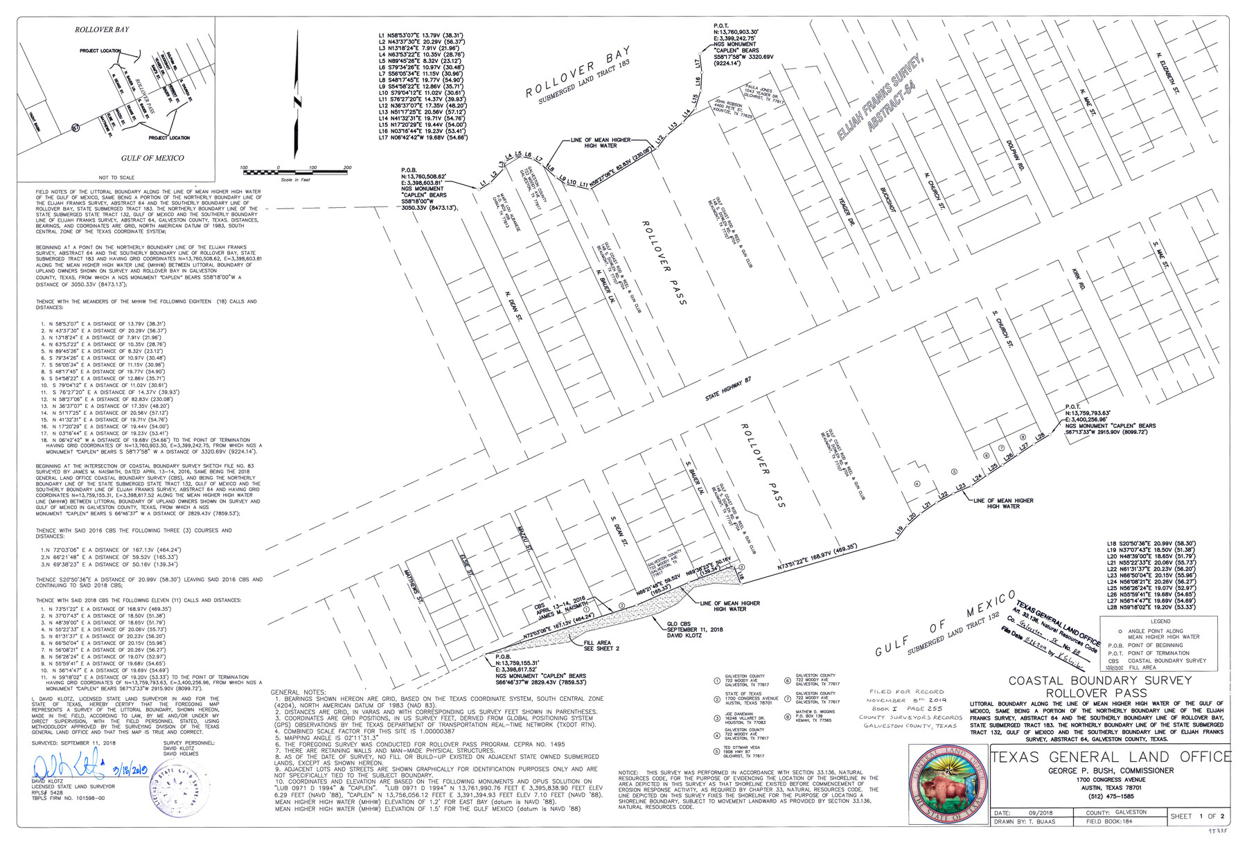
Coastal Boundary Survey Rollover Pass
-
Map/Doc
95735
-
Collection
General Map Collection
-
Object Dates
2018/9/11 (Survey Date)
2019/3/18 (Creation Date)
2019/11/26 (File Date)
-
People and Organizations
David Klotz (Surveyor/Engineer)
Travis Buaas (Draftsman)
David Holmes (Chainman/Field Personnel)
-
Counties
Galveston
-
Subjects
Surveying CBS
-
Height x Width
24.6 x 36.3 inches
62.5 x 92.2 cm
-
Medium
multi-page, multi-format
-
Comments
Project: Rollover Pass Closure, Galveston County Project No.: CEPRA No. 1495
Part of: General Map Collection
Angelina County Working Sketch 13

Print $20.00
- Digital $50.00
Angelina County Working Sketch 13
1935
Size 30.8 x 35.4 inches
Map/Doc 67094
Trinity County Rolled Sketch 3

Print $40.00
- Digital $50.00
Trinity County Rolled Sketch 3
1948
Size 33.8 x 50.3 inches
Map/Doc 10025
Hays County Rolled Sketch 33

Print $20.00
- Digital $50.00
Hays County Rolled Sketch 33
Size 15.4 x 19.1 inches
Map/Doc 89012
Pecos County Rolled Sketch 131

Print $20.00
- Digital $50.00
Pecos County Rolled Sketch 131
1950
Size 28.6 x 26.4 inches
Map/Doc 7269
Colorado County Working Sketch 30

Print $20.00
- Digital $50.00
Colorado County Working Sketch 30
1980
Size 22.2 x 19.8 inches
Map/Doc 68130
Flight Mission No. DQN-2K, Frame 80, Calhoun County

Print $20.00
- Digital $50.00
Flight Mission No. DQN-2K, Frame 80, Calhoun County
1953
Size 18.4 x 22.2 inches
Map/Doc 84272
Palo Pinto County Sketch File 1

Print $20.00
- Digital $50.00
Palo Pinto County Sketch File 1
Size 18.8 x 23.5 inches
Map/Doc 12131
Schleicher County Sketch File 7

Print $10.00
- Digital $50.00
Schleicher County Sketch File 7
1881
Size 13.0 x 8.2 inches
Map/Doc 36474
Aransas Pass to Baffin Bay

Print $20.00
- Digital $50.00
Aransas Pass to Baffin Bay
1966
Size 42.3 x 35.0 inches
Map/Doc 73415
Trinity County Sketch File 11

Print $8.00
- Digital $50.00
Trinity County Sketch File 11
1859
Size 6.2 x 6.2 inches
Map/Doc 38531
Limestone County Working Sketch 14

Print $20.00
- Digital $50.00
Limestone County Working Sketch 14
1922
Size 36.2 x 34.1 inches
Map/Doc 70564
Baylor County Sketch File Z1

Print $12.00
- Digital $50.00
Baylor County Sketch File Z1
1901
Size 8.8 x 7.2 inches
Map/Doc 14104
You may also like
[Blocks N and B]
![90498, [Blocks N and B], Twichell Survey Records](https://historictexasmaps.com/wmedia_w700/maps/90498-1.tif.jpg)
Print $3.00
- Digital $50.00
[Blocks N and B]
Size 10.0 x 11.4 inches
Map/Doc 90498
Acts of the Visit of the Royal Commissioners (sometimes referred to as the “Visita General”) - Reynosa

Acts of the Visit of the Royal Commissioners (sometimes referred to as the “Visita General”) - Reynosa
1767
Size 14.1 x 9.3 inches
Map/Doc 94258
Harris County Working Sketch 2

Print $20.00
- Digital $50.00
Harris County Working Sketch 2
Size 32.3 x 31.7 inches
Map/Doc 65894
Webb County Sketch File 19

Print $15.00
- Digital $50.00
Webb County Sketch File 19
1902
Size 9.2 x 17.0 inches
Map/Doc 39822
Houston Ship Channel, Atkinson Island to Alexander Island

Print $20.00
- Digital $50.00
Houston Ship Channel, Atkinson Island to Alexander Island
1960
Size 33.2 x 44.0 inches
Map/Doc 69900
Flight Mission No. BQY-4M, Frame 32, Harris County

Print $20.00
- Digital $50.00
Flight Mission No. BQY-4M, Frame 32, Harris County
1953
Size 18.6 x 22.6 inches
Map/Doc 85247
Map of Parmer County

Print $20.00
- Digital $50.00
Map of Parmer County
1900
Size 47.8 x 41.3 inches
Map/Doc 16786
Sterling County Sketch File 24

Print $6.00
- Digital $50.00
Sterling County Sketch File 24
1955
Size 11.1 x 8.5 inches
Map/Doc 37189
Official Railroad and County Map of Texas

Print $40.00
Official Railroad and County Map of Texas
1914
Size 45.8 x 48.6 inches
Map/Doc 76233
[Sketch of surveys in the vicinity of sections 171 and 172 along Pedernales]
![91882, [Sketch of surveys in the vicinity of sections 171 and 172 along Pedernales], Twichell Survey Records](https://historictexasmaps.com/wmedia_w700/maps/91882-1.tif.jpg)
Print $20.00
- Digital $50.00
[Sketch of surveys in the vicinity of sections 171 and 172 along Pedernales]
Size 17.2 x 12.9 inches
Map/Doc 91882
Knox County Boundary File 5a

Print $22.00
- Digital $50.00
Knox County Boundary File 5a
Size 15.6 x 38.5 inches
Map/Doc 65047
Sketch in Cochran County, Texas

Print $20.00
- Digital $50.00
Sketch in Cochran County, Texas
1949
Size 22.4 x 21.6 inches
Map/Doc 92523