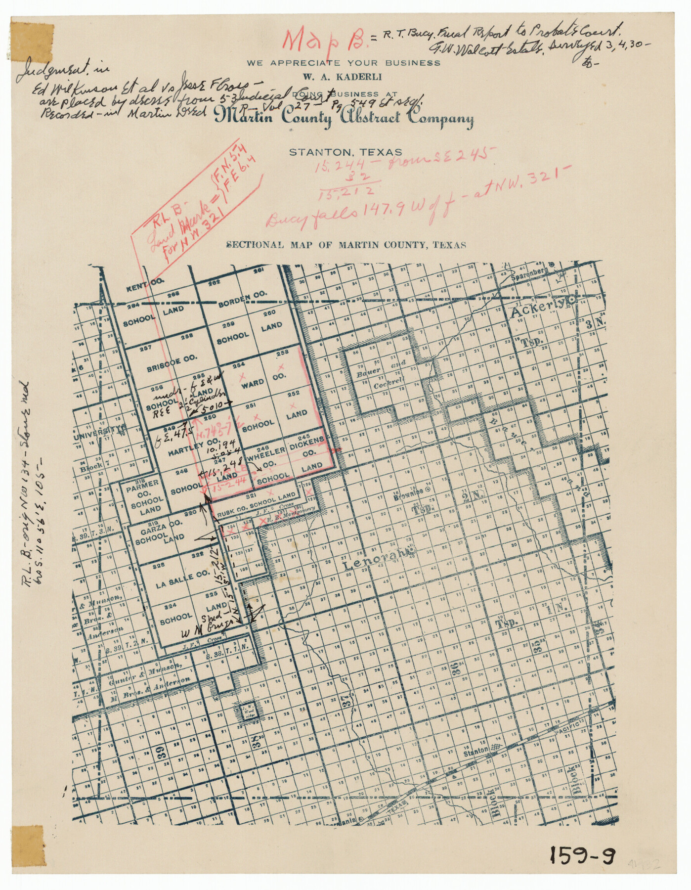
Sectional Map of Martin County, Texas
159-9
-
Map/Doc
91293
-
Collection
Twichell Survey Records
-
Counties
Martin
-
Height x Width
9.6 x 12.1 inches
24.4 x 30.7 cm
Part of: Twichell Survey Records
[Sketch showing correct location of the North and East lines of the Nave McCord pasture fence]
![90896, [Sketch showing correct location of the North and East lines of the Nave McCord pasture fence], Twichell Survey Records](https://historictexasmaps.com/wmedia_w700/maps/90896-1.tif.jpg)
Print $20.00
- Digital $50.00
[Sketch showing correct location of the North and East lines of the Nave McCord pasture fence]
1900
Size 20.3 x 11.8 inches
Map/Doc 90896
[Topographical Map]
![92543, [Topographical Map], Twichell Survey Records](https://historictexasmaps.com/wmedia_w700/maps/92543-1.tif.jpg)
Print $20.00
- Digital $50.00
[Topographical Map]
Size 31.2 x 37.5 inches
Map/Doc 92543
King County Survey made by A. C. Tackitt and W. D. Twichell

Print $20.00
- Digital $50.00
King County Survey made by A. C. Tackitt and W. D. Twichell
1916
Size 25.8 x 30.8 inches
Map/Doc 92147
[West Central Portion of County]
![91257, [West Central Portion of County], Twichell Survey Records](https://historictexasmaps.com/wmedia_w700/maps/91257-1.tif.jpg)
Print $20.00
- Digital $50.00
[West Central Portion of County]
Size 19.5 x 9.8 inches
Map/Doc 91257
Reconnaissance Map, Roby Sheet

Print $20.00
- Digital $50.00
Reconnaissance Map, Roby Sheet
1893
Size 17.0 x 20.8 inches
Map/Doc 90869
[Township 3 North, Block 33]
![91215, [Township 3 North, Block 33], Twichell Survey Records](https://historictexasmaps.com/wmedia_w700/maps/91215-1.tif.jpg)
Print $3.00
- Digital $50.00
[Township 3 North, Block 33]
Size 11.2 x 17.0 inches
Map/Doc 91215
Working Sketch Bastrop County

Print $20.00
- Digital $50.00
Working Sketch Bastrop County
1923
Size 23.2 x 13.0 inches
Map/Doc 90151
[Leagues 445, 465-468, Block B, Gregg County School Land Leagues 1 and 2]
![90532, [Leagues 445, 465-468, Block B, Gregg County School Land Leagues 1 and 2], Twichell Survey Records](https://historictexasmaps.com/wmedia_w700/maps/90532-1.tif.jpg)
Print $2.00
- Digital $50.00
[Leagues 445, 465-468, Block B, Gregg County School Land Leagues 1 and 2]
1902
Size 9.0 x 9.9 inches
Map/Doc 90532
[Floyd County School Land Lgs. 180-183, Fisher County School Land Lgs. 105-108, and part of Blk. V]
![90192, [Floyd County School Land Lgs. 180-183, Fisher County School Land Lgs. 105-108, and part of Blk. V], Twichell Survey Records](https://historictexasmaps.com/wmedia_w700/maps/90192-1.tif.jpg)
Print $2.00
- Digital $50.00
[Floyd County School Land Lgs. 180-183, Fisher County School Land Lgs. 105-108, and part of Blk. V]
Size 8.7 x 10.2 inches
Map/Doc 90192
Sketch in Cochran County, Texas

Print $20.00
- Digital $50.00
Sketch in Cochran County, Texas
1949
Size 22.4 x 21.6 inches
Map/Doc 92523
Working Sketch in McMullen County

Print $20.00
- Digital $50.00
Working Sketch in McMullen County
1919
Size 20.3 x 31.7 inches
Map/Doc 91345
![89627, [Blks. 46 & 47], Twichell Survey Records](https://historictexasmaps.com/wmedia_w700/maps/89627-1.tif.jpg)
You may also like
Hudspeth County Working Sketch 64

Print $20.00
- Digital $50.00
Hudspeth County Working Sketch 64
2006
Size 30.1 x 37.1 inches
Map/Doc 83064
Dawson County Sketch showing survey made in accordance with an order of the Hon. District Court of Garza County July Term A.D. 1917 in the case of F. M. Weaver vs. A. W. Higginbotham #41

Print $20.00
- Digital $50.00
Dawson County Sketch showing survey made in accordance with an order of the Hon. District Court of Garza County July Term A.D. 1917 in the case of F. M. Weaver vs. A. W. Higginbotham #41
1917
Size 23.1 x 18.1 inches
Map/Doc 90637
Ector County Working Sketch 22

Print $20.00
- Digital $50.00
Ector County Working Sketch 22
1959
Size 24.2 x 36.6 inches
Map/Doc 68865
Map of the Texas & Pacific Railway from Fort Worth to El Paso

Print $40.00
- Digital $50.00
Map of the Texas & Pacific Railway from Fort Worth to El Paso
Size 24.0 x 76.5 inches
Map/Doc 64511
Jones County Sketch File 17

Print $20.00
- Digital $50.00
Jones County Sketch File 17
1910
Size 17.2 x 29.4 inches
Map/Doc 11902
Maps & Lists Showing Prison Lands (Oil & Gas) Leased as of June 1955

Print $2.00
- Digital $50.00
Maps & Lists Showing Prison Lands (Oil & Gas) Leased as of June 1955
1955
Size 11.2 x 8.8 inches
Map/Doc 62863
Presidio County Boundary File 2

Print $8.00
- Digital $50.00
Presidio County Boundary File 2
Size 14.0 x 8.6 inches
Map/Doc 58054
Pecos County Rolled Sketch 165

Print $20.00
- Digital $50.00
Pecos County Rolled Sketch 165
1966
Size 23.4 x 19.6 inches
Map/Doc 7290
Henderson County Sketch File 3

Print $4.00
- Digital $50.00
Henderson County Sketch File 3
1852
Size 10.3 x 8.4 inches
Map/Doc 26321
United States and Territories, showing the extent of Public Surveys, Indian and Forest Reservations, Rail Roads, Canals and other detail, compiled from official surveys of the General Land Office and other authentic sources

Print $40.00
- Digital $50.00
United States and Territories, showing the extent of Public Surveys, Indian and Forest Reservations, Rail Roads, Canals and other detail, compiled from official surveys of the General Land Office and other authentic sources
1897
Size 59.5 x 85.8 inches
Map/Doc 93969
Pecos County Rolled Sketch DK1

Print $20.00
- Digital $50.00
Pecos County Rolled Sketch DK1
1938
Size 36.2 x 43.7 inches
Map/Doc 9713
The Military History of Texas Map!

The Military History of Texas Map!
1996
Size 24.2 x 35.0 inches
Map/Doc 96828