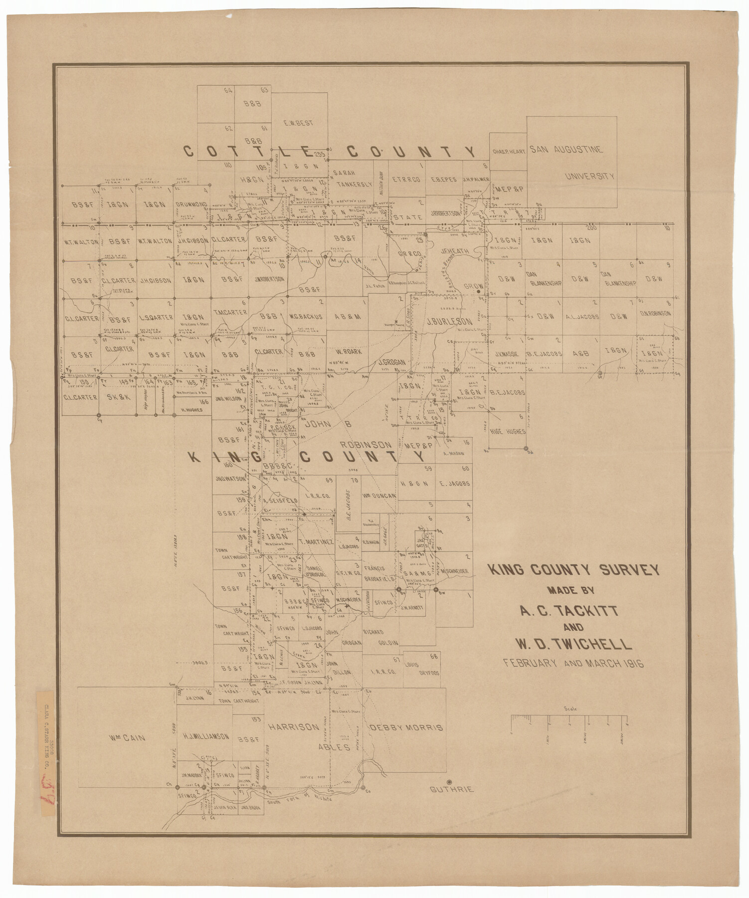
King County Survey made by A. C. Tackitt and W. D. Twichell
-
Map/Doc
92147
-
Collection
Twichell Survey Records
-
Object Dates
3/1916 (Creation Date)
-
People and Organizations
W.D. Twichell (Surveyor/Engineer)
A.C. Tackitt (Surveyor/Engineer)
-
Counties
King Cottle
-
Height x Width
25.8 x 30.8 inches
65.5 x 78.2 cm
Part of: Twichell Survey Records
[Block 1 and surrounding blocks]
![90755, [Block 1 and surrounding blocks], Twichell Survey Records](https://historictexasmaps.com/wmedia_w700/maps/90755-1.tif.jpg)
Print $20.00
- Digital $50.00
[Block 1 and surrounding blocks]
1903
Size 18.8 x 19.8 inches
Map/Doc 90755
[Leagues 575, 578, 609, and 616, Blocks T2, T3, and K13]
![91053, [Leagues 575, 578, 609, and 616, Blocks T2, T3, and K13], Twichell Survey Records](https://historictexasmaps.com/wmedia_w700/maps/91053-1.tif.jpg)
Print $20.00
- Digital $50.00
[Leagues 575, 578, 609, and 616, Blocks T2, T3, and K13]
Size 20.5 x 20.0 inches
Map/Doc 91053
![91465, [Block B7], Twichell Survey Records](https://historictexasmaps.com/wmedia_w700/maps/91465-1.tif.jpg)
Map of a part of Block One, I. & G. N. RR. Co. and the Pecos River

Print $20.00
- Digital $50.00
Map of a part of Block One, I. & G. N. RR. Co. and the Pecos River
1927
Size 34.2 x 17.4 inches
Map/Doc 90320
[Guadalupe College]
![91907, [Guadalupe College], Twichell Survey Records](https://historictexasmaps.com/wmedia_w700/maps/91907-1.tif.jpg)
Print $3.00
- Digital $50.00
[Guadalupe College]
Size 16.7 x 9.7 inches
Map/Doc 91907
Plat Showing Subdivision of Wilbarger County School Land Hockley County, Texas

Print $20.00
- Digital $50.00
Plat Showing Subdivision of Wilbarger County School Land Hockley County, Texas
1947
Size 20.0 x 20.9 inches
Map/Doc 92255
Block 1 H&GN RR Co.

Print $20.00
- Digital $50.00
Block 1 H&GN RR Co.
Size 39.3 x 40.3 inches
Map/Doc 89769
[County Line, Roberts and Hutchinson County]
![91184, [County Line, Roberts and Hutchinson County], Twichell Survey Records](https://historictexasmaps.com/wmedia_w700/maps/91184-1.tif.jpg)
Print $20.00
- Digital $50.00
[County Line, Roberts and Hutchinson County]
1907
Size 33.7 x 7.7 inches
Map/Doc 91184
[Map showing Block 35, Townships 1N-5N]
![93207, [Map showing Block 35, Townships 1N-5N], Twichell Survey Records](https://historictexasmaps.com/wmedia_w700/maps/93207-1.tif.jpg)
Print $40.00
- Digital $50.00
[Map showing Block 35, Townships 1N-5N]
Size 22.8 x 83.0 inches
Map/Doc 93207
[Sketch showing H. & T. C. R. R. Co. Blk. 48, S. P. R. R. Co. Blk. I, and E. T. R. R. Co. Blk. I]
![89625, [Sketch showing H. & T. C. R. R. Co. Blk. 48, S. P. R. R. Co. Blk. I, and E. T. R. R. Co. Blk. I], Twichell Survey Records](https://historictexasmaps.com/wmedia_w700/maps/89625-1.tif.jpg)
Print $40.00
- Digital $50.00
[Sketch showing H. & T. C. R. R. Co. Blk. 48, S. P. R. R. Co. Blk. I, and E. T. R. R. Co. Blk. I]
Size 51.1 x 9.4 inches
Map/Doc 89625
Brazos River Conservation and Reclamation District Official Boundary Line Survey

Print $20.00
- Digital $50.00
Brazos River Conservation and Reclamation District Official Boundary Line Survey
1931
Size 25.1 x 36.9 inches
Map/Doc 90125
[H. & T. C. RR. Company Block 47, Sections 47, 48, 49, 50, 51, and 52]
![91221, [H. & T. C. RR. Company Block 47, Sections 47, 48, 49, 50, 51, and 52], Twichell Survey Records](https://historictexasmaps.com/wmedia_w700/maps/91221-1.tif.jpg)
Print $2.00
- Digital $50.00
[H. & T. C. RR. Company Block 47, Sections 47, 48, 49, 50, 51, and 52]
Size 8.5 x 11.2 inches
Map/Doc 91221
You may also like
Cherokee County Sketch File 16

Print $44.00
- Digital $50.00
Cherokee County Sketch File 16
1862
Size 10.0 x 8.0 inches
Map/Doc 18152
[B. S. & F. Block 9]
![91812, [B. S. & F. Block 9], Twichell Survey Records](https://historictexasmaps.com/wmedia_w700/maps/91812-1.tif.jpg)
Print $20.00
- Digital $50.00
[B. S. & F. Block 9]
Size 38.0 x 18.6 inches
Map/Doc 91812
Flight Mission No. DQN-1K, Frame 78, Calhoun County

Print $20.00
- Digital $50.00
Flight Mission No. DQN-1K, Frame 78, Calhoun County
1953
Size 18.5 x 22.1 inches
Map/Doc 84163
General Highway Map, Eastland County, Texas

Print $20.00
General Highway Map, Eastland County, Texas
1940
Size 18.1 x 24.8 inches
Map/Doc 79080
Terrell County Working Sketch 79

Print $40.00
- Digital $50.00
Terrell County Working Sketch 79
1983
Size 43.0 x 55.8 inches
Map/Doc 69600
Gillespie County Rolled Sketch 3

Print $20.00
- Digital $50.00
Gillespie County Rolled Sketch 3
Size 19.0 x 28.1 inches
Map/Doc 6010

Topographic Map of Texas and Oklahoma Boundary, Fort Augur Area

Print $20.00
Topographic Map of Texas and Oklahoma Boundary, Fort Augur Area
1924
Size 32.3 x 33.8 inches
Map/Doc 79755
Cooke County Rolled Sketch 7

Print $20.00
- Digital $50.00
Cooke County Rolled Sketch 7
2002
Size 44.8 x 34.9 inches
Map/Doc 77525
[Map of] North America
![88884, [Map of] North America, General Map Collection](https://historictexasmaps.com/wmedia_w700/maps/88884.tif.jpg)
Print $3.00
- Digital $50.00
[Map of] North America
1834
Size 11.0 x 8.5 inches
Map/Doc 88884
Hidalgo County Sketch File 16

Print $12.00
- Digital $50.00
Hidalgo County Sketch File 16
1914
Size 11.2 x 8.9 inches
Map/Doc 26437
Freestone County Working Sketch 13

Print $40.00
- Digital $50.00
Freestone County Working Sketch 13
1980
Size 42.8 x 59.7 inches
Map/Doc 69255