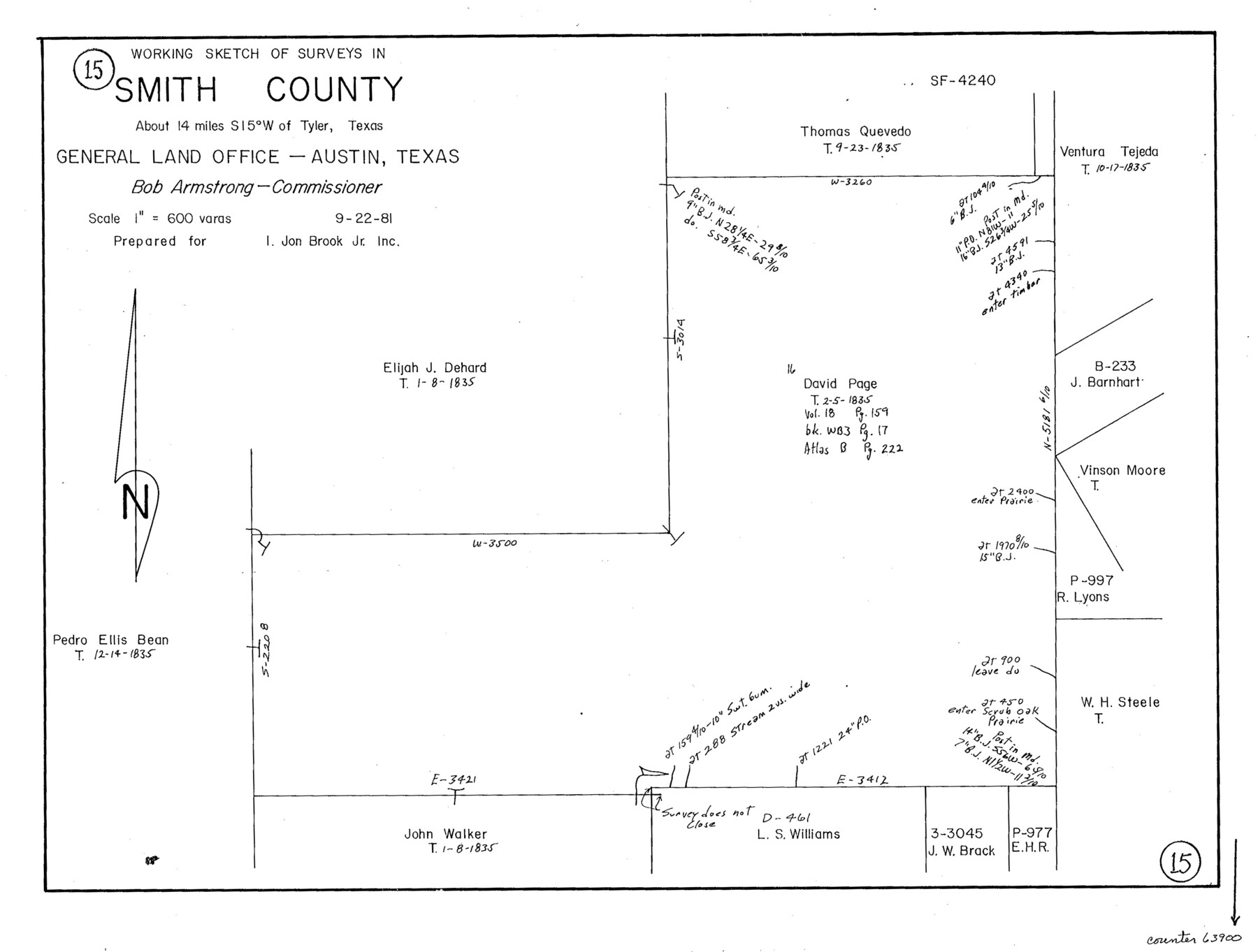
Smith County Working Sketch 15
-
Map/Doc
63900
-
Collection
General Map Collection
-
Counties
Smith
-
Subjects
Cadastral Surveying Working Sketch
-
Height x Width
13.4 x 17.6 inches
34.0 x 44.7 cm
Part of: General Map Collection
Hudspeth County Sketch File AQ1
![26922, Hudspeth County Sketch File AQ1, General Map Collection](https://historictexasmaps.com/wmedia_w700/pdf_converted_jpg/qi_pdf_thumbnail_12034.jpg)
Print $4.00
- Digital $50.00
Hudspeth County Sketch File AQ1
1902
Size 10.9 x 8.7 inches
Map/Doc 26922
Coryell County Sketch File 17
![19375, Coryell County Sketch File 17, General Map Collection](https://historictexasmaps.com/wmedia_w700/pdf_converted_jpg/qi_pdf_thumbnail_10409.jpg)
Print $4.00
- Digital $50.00
Coryell County Sketch File 17
1854
Size 6.7 x 8.4 inches
Map/Doc 19375
Rockwall County Sketch File 6
![35425, Rockwall County Sketch File 6, General Map Collection](https://historictexasmaps.com/wmedia_w700/pdf_converted_jpg/qi_pdf_thumbnail_13926.jpg)
Print $4.00
- Digital $50.00
Rockwall County Sketch File 6
1862
Size 8.5 x 9.4 inches
Map/Doc 35425
Red River County Working Sketch 85
![83582, Red River County Working Sketch 85, General Map Collection](https://historictexasmaps.com/wmedia_w700/maps/83582.tif.jpg)
Print $20.00
- Digital $50.00
Red River County Working Sketch 85
2005
Size 27.4 x 44.0 inches
Map/Doc 83582
A Map of the Indian Territory, Northern Texas and New Mexico Showing the Great Western Prairies
![95700, A Map of the Indian Territory, Northern Texas and New Mexico Showing the Great Western Prairies, General Map Collection](https://historictexasmaps.com/wmedia_w700/maps/95700.tif.jpg)
Print $20.00
- Digital $50.00
A Map of the Indian Territory, Northern Texas and New Mexico Showing the Great Western Prairies
1844
Size 14.0 x 17.6 inches
Map/Doc 95700
Orange County Boundary File 7
![57775, Orange County Boundary File 7, General Map Collection](https://historictexasmaps.com/wmedia_w700/pdf_converted_jpg/qi_pdf_thumbnail_16647.jpg)
Print $10.00
- Digital $50.00
Orange County Boundary File 7
Size 4.1 x 7.6 inches
Map/Doc 57775
Crockett County Sketch File F
![11240, Crockett County Sketch File F, General Map Collection](https://historictexasmaps.com/wmedia_w700/pdf_converted_jpg/qi_pdf_thumbnail_7741.jpg)
Print $20.00
- Digital $50.00
Crockett County Sketch File F
1907
Size 26.3 x 15.7 inches
Map/Doc 11240
Missouri Pacific Railway System
![89223, Missouri Pacific Railway System, General Map Collection](https://historictexasmaps.com/wmedia_w700/maps/89223.tif.jpg)
Print $20.00
- Digital $50.00
Missouri Pacific Railway System
1888
Size 20.0 x 20.0 inches
Map/Doc 89223
Zapata County Rolled Sketch 19
![8316, Zapata County Rolled Sketch 19, General Map Collection](https://historictexasmaps.com/wmedia_w700/maps/8316.tif.jpg)
Print $20.00
- Digital $50.00
Zapata County Rolled Sketch 19
1955
Size 29.0 x 20.9 inches
Map/Doc 8316
Oldham County Rolled Sketch 12
![7177, Oldham County Rolled Sketch 12, General Map Collection](https://historictexasmaps.com/wmedia_w700/maps/7177.tif.jpg)
Print $20.00
- Digital $50.00
Oldham County Rolled Sketch 12
1981
Size 25.2 x 38.0 inches
Map/Doc 7177
Briscoe County Sketch File N
![11012, Briscoe County Sketch File N, General Map Collection](https://historictexasmaps.com/wmedia_w700/pdf_converted_jpg/qi_pdf_thumbnail_7579.jpg)
Print $40.00
- Digital $50.00
Briscoe County Sketch File N
Size 26.0 x 21.9 inches
Map/Doc 11012
Edwards County Working Sketch 33
![68909, Edwards County Working Sketch 33, General Map Collection](https://historictexasmaps.com/wmedia_w700/maps/68909.tif.jpg)
Print $40.00
- Digital $50.00
Edwards County Working Sketch 33
Size 42.6 x 50.2 inches
Map/Doc 68909
You may also like
Fort Bend County Sketch File 4
![22885, Fort Bend County Sketch File 4, General Map Collection](https://historictexasmaps.com/wmedia_w700/pdf_converted_jpg/qi_pdf_thumbnail_11186.jpg)
Print $4.00
- Digital $50.00
Fort Bend County Sketch File 4
1876
Size 10.0 x 8.4 inches
Map/Doc 22885
Right of Way and Track Map, International & Gt. Northern Ry. operated by the International & Gt. Northern Ry. Co. Gulf Division, Mineola Branch
![64700, Right of Way and Track Map, International & Gt. Northern Ry. operated by the International & Gt. Northern Ry. Co. Gulf Division, Mineola Branch, General Map Collection](https://historictexasmaps.com/wmedia_w700/maps/64700.tif.jpg)
Print $40.00
- Digital $50.00
Right of Way and Track Map, International & Gt. Northern Ry. operated by the International & Gt. Northern Ry. Co. Gulf Division, Mineola Branch
1917
Size 26.3 x 125.4 inches
Map/Doc 64700
Flight Mission No. DAG-28K, Frame 27, Matagorda County
![86595, Flight Mission No. DAG-28K, Frame 27, Matagorda County, General Map Collection](https://historictexasmaps.com/wmedia_w700/pdf_converted_jpg/qi_pdf_thumbnail_33735.jpg)
Print $20.00
- Digital $50.00
Flight Mission No. DAG-28K, Frame 27, Matagorda County
1953
Size 16.2 x 16.1 inches
Map/Doc 86595
Lake Corpus Christi and a city map of Mathis, Texas [Verso]
![94171, Lake Corpus Christi and a city map of Mathis, Texas [Verso], General Map Collection](https://historictexasmaps.com/wmedia_w700/maps/94171.tif.jpg)
Lake Corpus Christi and a city map of Mathis, Texas [Verso]
1984
Size 29.3 x 22.9 inches
Map/Doc 94171
[Sketch in DeWitt County]
![78383, [Sketch in DeWitt County], General Map Collection](https://historictexasmaps.com/wmedia_w700/maps/78383.tif.jpg)
Print $3.00
- Digital $50.00
[Sketch in DeWitt County]
Size 9.3 x 10.1 inches
Map/Doc 78383
Bissell's railway junction point map of Texas / especially designed and adapted for the computation of shortline distances in the application of freight rates promulgated by the Railroad Commission of Texas.
![93600, Bissell's railway junction point map of Texas / especially designed and adapted for the computation of shortline distances in the application of freight rates promulgated by the Railroad Commission of Texas., Library of Congress](https://historictexasmaps.com/wmedia_w700/maps/93600.tif.jpg)
Print $20.00
Bissell's railway junction point map of Texas / especially designed and adapted for the computation of shortline distances in the application of freight rates promulgated by the Railroad Commission of Texas.
1891
Size 31.5 x 26.8 inches
Map/Doc 93600
Amistad International Reservoir on Rio Grande 97
![75528, Amistad International Reservoir on Rio Grande 97, General Map Collection](https://historictexasmaps.com/wmedia_w700/maps/75528.tif.jpg)
Print $20.00
- Digital $50.00
Amistad International Reservoir on Rio Grande 97
1950
Size 28.5 x 41.1 inches
Map/Doc 75528
Potter County Sketch File 5
![34387, Potter County Sketch File 5, General Map Collection](https://historictexasmaps.com/wmedia_w700/pdf_converted_jpg/qi_pdf_thumbnail_13676.jpg)
Print $20.00
- Digital $50.00
Potter County Sketch File 5
1890
Size 14.1 x 8.8 inches
Map/Doc 34387
Dallam County Sketch File 9
![20357, Dallam County Sketch File 9, General Map Collection](https://historictexasmaps.com/wmedia_w700/pdf_converted_jpg/qi_pdf_thumbnail_10600.jpg)
Print $40.00
- Digital $50.00
Dallam County Sketch File 9
1914
Size 9.0 x 7.7 inches
Map/Doc 20357
Sterling County Working Sketch 11
![63993, Sterling County Working Sketch 11, General Map Collection](https://historictexasmaps.com/wmedia_w700/maps/63993.tif.jpg)
Print $20.00
- Digital $50.00
Sterling County Working Sketch 11
Size 20.1 x 40.8 inches
Map/Doc 63993
J. De Cordova's Map of the State of Texas Compiled from the records of the General Land Office of the State
![7826, J. De Cordova's Map of the State of Texas Compiled from the records of the General Land Office of the State, General Map Collection](https://historictexasmaps.com/wmedia_w700/maps/7826-1.tif.jpg)
Print $20.00
- Digital $50.00
J. De Cordova's Map of the State of Texas Compiled from the records of the General Land Office of the State
1849
Size 33.9 x 32.1 inches
Map/Doc 7826
Ector County Working Sketch 18
![68861, Ector County Working Sketch 18, General Map Collection](https://historictexasmaps.com/wmedia_w700/maps/68861.tif.jpg)
Print $20.00
- Digital $50.00
Ector County Working Sketch 18
Size 42.0 x 39.1 inches
Map/Doc 68861