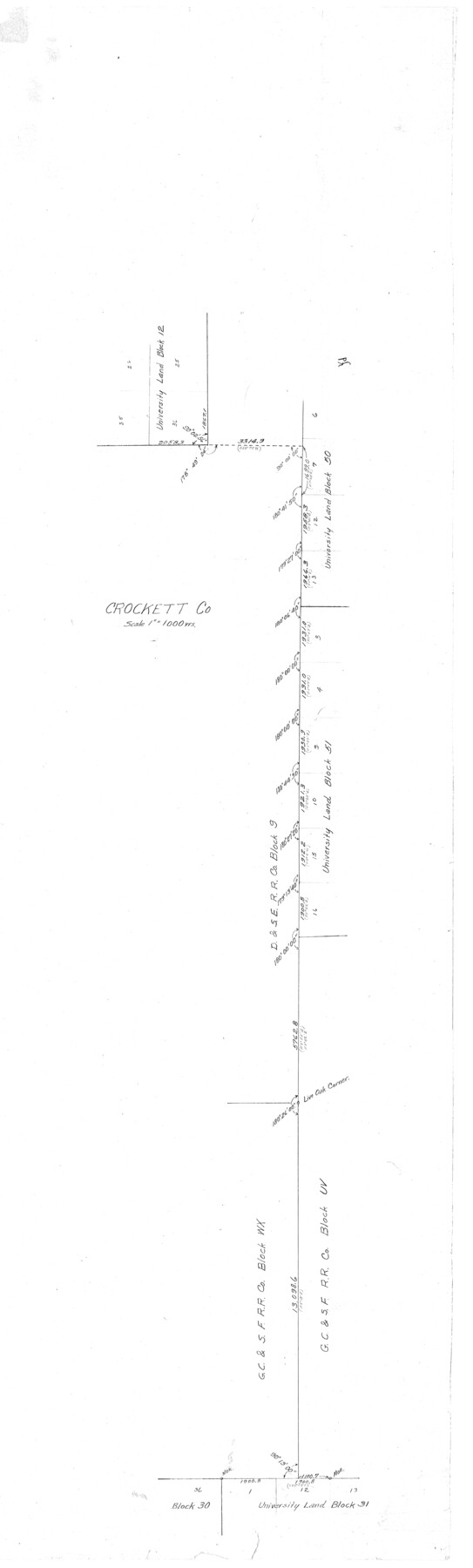
Crockett County Rolled Sketch 45
Crockett Co. [connecting line]
-
Map/Doc
8710
-
Collection
General Map Collection
-
Object Dates
1938/1/31 (File Date)
-
Counties
Crockett
-
Subjects
Surveying Rolled Sketch
-
Height x Width
54.8 x 16.5 inches
139.2 x 41.9 cm
-
Scale
1" = 1000 varas
Part of: General Map Collection
Plat of Jasper, Sabine, San Augustine, Shelby, Harrison and South Part of Nacogdoches Counties

Print $2.00
- Digital $50.00
Plat of Jasper, Sabine, San Augustine, Shelby, Harrison and South Part of Nacogdoches Counties
1841
Size 13.7 x 9.2 inches
Map/Doc 3174
Gaines County Working Sketch 2

Print $20.00
- Digital $50.00
Gaines County Working Sketch 2
1939
Size 29.4 x 39.9 inches
Map/Doc 69302
Garza County Working Sketch Graphic Index

Print $20.00
- Digital $50.00
Garza County Working Sketch Graphic Index
1928
Size 46.7 x 36.2 inches
Map/Doc 76552
Flight Mission No. DQN-1K, Frame 107, Calhoun County

Print $20.00
- Digital $50.00
Flight Mission No. DQN-1K, Frame 107, Calhoun County
1953
Size 18.4 x 22.3 inches
Map/Doc 84174
Northeast Part of Crockett County

Print $20.00
- Digital $50.00
Northeast Part of Crockett County
1976
Size 31.4 x 41.0 inches
Map/Doc 77253
Map of Shackelford County

Print $20.00
- Digital $50.00
Map of Shackelford County
1895
Size 24.1 x 19.5 inches
Map/Doc 4026
Webb County Sketch File 8

Print $4.00
- Digital $50.00
Webb County Sketch File 8
1875
Size 8.3 x 8.7 inches
Map/Doc 39741
[St. Louis & Southwestern]
![64278, [St. Louis & Southwestern], General Map Collection](https://historictexasmaps.com/wmedia_w700/maps/64278.tif.jpg)
Print $20.00
- Digital $50.00
[St. Louis & Southwestern]
Size 20.8 x 28.9 inches
Map/Doc 64278
No. 2 Chart of Corpus Christi Pass, Texas

Print $20.00
- Digital $50.00
No. 2 Chart of Corpus Christi Pass, Texas
1878
Size 18.3 x 27.4 inches
Map/Doc 73018
Tom Green County Sketch File 81

Print $20.00
- Digital $50.00
Tom Green County Sketch File 81
Size 16.6 x 23.4 inches
Map/Doc 12453
Comanche County Working Sketch 20

Print $20.00
- Digital $50.00
Comanche County Working Sketch 20
1973
Size 20.5 x 15.6 inches
Map/Doc 68154
Starr County Sketch File 17

Print $24.00
- Digital $50.00
Starr County Sketch File 17
1880
Size 12.8 x 8.2 inches
Map/Doc 36874
You may also like
[G. & M. Block 5]
![91802, [G. & M. Block 5], Twichell Survey Records](https://historictexasmaps.com/wmedia_w700/maps/91802-1.tif.jpg)
Print $20.00
- Digital $50.00
[G. & M. Block 5]
Size 20.3 x 12.5 inches
Map/Doc 91802
Marion County Rolled Sketch 3

Print $20.00
- Digital $50.00
Marion County Rolled Sketch 3
1955
Size 35.4 x 35.5 inches
Map/Doc 9490
Aerial Photos

Print $20.00
- Digital $50.00
Aerial Photos
1937
Size 15.9 x 12.4 inches
Map/Doc 92106
Harris County Sketch File 3

Print $4.00
- Digital $50.00
Harris County Sketch File 3
Size 7.0 x 6.2 inches
Map/Doc 25334
Flight Mission No. DCL-6C, Frame 116, Kenedy County

Print $20.00
- Digital $50.00
Flight Mission No. DCL-6C, Frame 116, Kenedy County
1943
Size 18.6 x 22.2 inches
Map/Doc 85946
[T. & P. Blocks 31-36, Townships 1N-5N]
![93054, [T. & P. Blocks 31-36, Townships 1N-5N], Twichell Survey Records](https://historictexasmaps.com/wmedia_w700/maps/93054-1.tif.jpg)
Print $20.00
- Digital $50.00
[T. & P. Blocks 31-36, Townships 1N-5N]
Size 14.2 x 17.4 inches
Map/Doc 93054
McCulloch County Sketch File 11

Print $14.00
- Digital $50.00
McCulloch County Sketch File 11
1929
Size 11.2 x 8.8 inches
Map/Doc 31191
Houston Ship Channel

Print $20.00
- Digital $50.00
Houston Ship Channel
1926
Size 32.9 x 38.3 inches
Map/Doc 69893
Flight Mission No. CGI-3N, Frame 126, Cameron County

Print $20.00
- Digital $50.00
Flight Mission No. CGI-3N, Frame 126, Cameron County
1954
Size 18.5 x 22.1 inches
Map/Doc 84599
West Half - Brown County

Print $40.00
- Digital $50.00
West Half - Brown County
1982
Size 142.2 x 37.3 inches
Map/Doc 97384
Nueces County Rolled Sketch 131

Print $20.00
- Digital $50.00
Nueces County Rolled Sketch 131
2000
Size 24.2 x 36.6 inches
Map/Doc 7166
Reyno de la Nueva España a Principios del Siglo XIX

Print $20.00
- Digital $50.00
Reyno de la Nueva España a Principios del Siglo XIX
1885
Size 25.6 x 32.7 inches
Map/Doc 93751