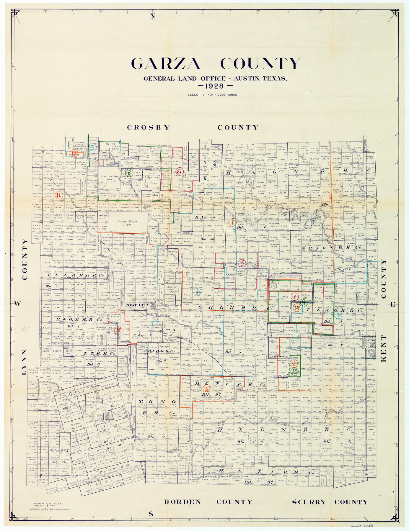
Garza County Working Sketch Graphic Index
-
Map/Doc
76552
-
Collection
General Map Collection
-
Object Dates
1928/7/3 (Creation Date)
-
Counties
Garza
-
Subjects
Cadastral County Surveying Working Sketch
-
Height x Width
46.7 x 36.2 inches
118.6 x 91.9 cm
Part of: General Map Collection
Hockley County
![77313, Hockley County, General Map Collection](https://historictexasmaps.com/wmedia_w700/maps/77313.tif.jpg)
Print $20.00
- Digital $50.00
Hockley County
1954
Size 41.0 x 36.4 inches
Map/Doc 77313
Harris County Rolled Sketch 100
![77535, Harris County Rolled Sketch 100, General Map Collection](https://historictexasmaps.com/wmedia_w700/maps/77535.tif.jpg)
Print $20.00
- Digital $50.00
Harris County Rolled Sketch 100
2002
Size 24.2 x 36.9 inches
Map/Doc 77535
Cottle County Sketch File 3a
![19459, Cottle County Sketch File 3a, General Map Collection](https://historictexasmaps.com/wmedia_w700/pdf_converted_jpg/qi_pdf_thumbnail_10425.jpg)
Print $14.00
- Digital $50.00
Cottle County Sketch File 3a
Size 12.9 x 8.8 inches
Map/Doc 19459
Sterling County
![16820, Sterling County, General Map Collection](https://historictexasmaps.com/wmedia_w700/maps/16820.tif.jpg)
Print $20.00
- Digital $50.00
Sterling County
1926
Size 47.8 x 35.2 inches
Map/Doc 16820
Jeff Davis County Rolled Sketch 42
![76415, Jeff Davis County Rolled Sketch 42, General Map Collection](https://historictexasmaps.com/wmedia_w700/maps/76415.tif.jpg)
Print $20.00
- Digital $50.00
Jeff Davis County Rolled Sketch 42
1998
Size 26.8 x 18.9 inches
Map/Doc 76415
Pecos County Rolled Sketch 14
![75942, Pecos County Rolled Sketch 14, General Map Collection](https://historictexasmaps.com/wmedia_w700/maps/75942.tif.jpg)
Print $40.00
- Digital $50.00
Pecos County Rolled Sketch 14
Size 39.5 x 82.3 inches
Map/Doc 75942
Brewster County Working Sketch Graphic Index, North Part, Sheet 2 (Sketches 87 to Most Recent)
![76474, Brewster County Working Sketch Graphic Index, North Part, Sheet 2 (Sketches 87 to Most Recent), General Map Collection](https://historictexasmaps.com/wmedia_w700/maps/76474.tif.jpg)
Print $20.00
- Digital $50.00
Brewster County Working Sketch Graphic Index, North Part, Sheet 2 (Sketches 87 to Most Recent)
1956
Size 41.8 x 39.5 inches
Map/Doc 76474
Burnet County Working Sketch 6
![67849, Burnet County Working Sketch 6, General Map Collection](https://historictexasmaps.com/wmedia_w700/maps/67849.tif.jpg)
Print $20.00
- Digital $50.00
Burnet County Working Sketch 6
Size 20.5 x 31.0 inches
Map/Doc 67849
Map of the River Sabine shewing that portion of the Boundary between the Republic of Texas and the United States included between Logan's Ferry and the Intersection of the 32nd degree of N. Latitude with the Western bank of Sabine River
![65410, Map of the River Sabine shewing that portion of the Boundary between the Republic of Texas and the United States included between Logan's Ferry and the Intersection of the 32nd degree of N. Latitude with the Western bank of Sabine River, General Map Collection](https://historictexasmaps.com/wmedia_w700/maps/65410.tif.jpg)
Print $20.00
- Digital $50.00
Map of the River Sabine shewing that portion of the Boundary between the Republic of Texas and the United States included between Logan's Ferry and the Intersection of the 32nd degree of N. Latitude with the Western bank of Sabine River
1842
Size 19.2 x 27.3 inches
Map/Doc 65410
Starr County Sketch File 8
![36858, Starr County Sketch File 8, General Map Collection](https://historictexasmaps.com/wmedia_w700/pdf_converted_jpg/qi_pdf_thumbnail_14252.jpg)
Print $7.00
- Digital $50.00
Starr County Sketch File 8
Size 10.1 x 12.4 inches
Map/Doc 36858
Calhoun County Working Sketch 14
![67830, Calhoun County Working Sketch 14, General Map Collection](https://historictexasmaps.com/wmedia_w700/maps/67830.tif.jpg)
Print $20.00
- Digital $50.00
Calhoun County Working Sketch 14
Size 28.7 x 33.9 inches
Map/Doc 67830
Hudspeth County Working Sketch 14
![66296, Hudspeth County Working Sketch 14, General Map Collection](https://historictexasmaps.com/wmedia_w700/maps/66296-1.tif.jpg)
Print $20.00
- Digital $50.00
Hudspeth County Working Sketch 14
Size 24.2 x 41.2 inches
Map/Doc 66296
You may also like
General Highway Map, Armstrong County, Texas
![79354, General Highway Map, Armstrong County, Texas, Texas State Library and Archives](https://historictexasmaps.com/wmedia_w700/maps/79354.tif.jpg)
Print $20.00
General Highway Map, Armstrong County, Texas
1961
Size 18.3 x 25.0 inches
Map/Doc 79354
PSL Field Notes for Blocks A27 and A28 in Andrews and Gaines Counties, and Blocks A6 through A13, A20 through A26, and A30 in Gaines County
![81654, PSL Field Notes for Blocks A27 and A28 in Andrews and Gaines Counties, and Blocks A6 through A13, A20 through A26, and A30 in Gaines County, General Map Collection](https://historictexasmaps.com/wmedia_w700/pdf_converted_jpg/qi_pdf_thumbnail_30417.jpg)
PSL Field Notes for Blocks A27 and A28 in Andrews and Gaines Counties, and Blocks A6 through A13, A20 through A26, and A30 in Gaines County
Map/Doc 81654
Flight Mission No. CGI-3N, Frame 170, Cameron County
![84634, Flight Mission No. CGI-3N, Frame 170, Cameron County, General Map Collection](https://historictexasmaps.com/wmedia_w700/pdf_converted_jpg/qi_pdf_thumbnail_31849.jpg)
Print $20.00
- Digital $50.00
Flight Mission No. CGI-3N, Frame 170, Cameron County
1954
Size 18.6 x 22.3 inches
Map/Doc 84634
Gulf, Texas & Western Railway
![64430, Gulf, Texas & Western Railway, General Map Collection](https://historictexasmaps.com/wmedia_w700/maps/64430.tif.jpg)
Print $40.00
- Digital $50.00
Gulf, Texas & Western Railway
1909
Size 18.5 x 121.0 inches
Map/Doc 64430
Motley County Sketch File C (N)
![31978, Motley County Sketch File C (N), General Map Collection](https://historictexasmaps.com/wmedia_w700/pdf_converted_jpg/qi_pdf_thumbnail_13191.jpg)
Print $48.00
- Digital $50.00
Motley County Sketch File C (N)
Size 7.7 x 18.4 inches
Map/Doc 31978
Foard County Boundary File 5
![53536, Foard County Boundary File 5, General Map Collection](https://historictexasmaps.com/wmedia_w700/pdf_converted_jpg/qi_pdf_thumbnail_16043.jpg)
Print $20.00
- Digital $50.00
Foard County Boundary File 5
Size 10.3 x 8.8 inches
Map/Doc 53536
Kimble County Working Sketch 35
![70103, Kimble County Working Sketch 35, General Map Collection](https://historictexasmaps.com/wmedia_w700/maps/70103.tif.jpg)
Print $20.00
- Digital $50.00
Kimble County Working Sketch 35
Size 24.7 x 32.0 inches
Map/Doc 70103
Angelina County Sketch File 25
![13069, Angelina County Sketch File 25, General Map Collection](https://historictexasmaps.com/wmedia_w700/pdf_converted_jpg/qi_pdf_thumbnail_9083.jpg)
Print $8.00
- Digital $50.00
Angelina County Sketch File 25
1894
Size 7.0 x 10.2 inches
Map/Doc 13069
Liberty County Sketch File 27
![29948, Liberty County Sketch File 27, General Map Collection](https://historictexasmaps.com/wmedia_w700/pdf_converted_jpg/qi_pdf_thumbnail_12691.jpg)
Print $5.00
- Digital $50.00
Liberty County Sketch File 27
Size 11.5 x 9.3 inches
Map/Doc 29948
Reagan County Sketch File 30
![12226, Reagan County Sketch File 30, General Map Collection](https://historictexasmaps.com/wmedia_w700/pdf_converted_jpg/qi_pdf_thumbnail_8559.jpg)
Print $20.00
- Digital $50.00
Reagan County Sketch File 30
1951
Size 27.4 x 20.3 inches
Map/Doc 12226
Montague County Working Sketch 34
![71100, Montague County Working Sketch 34, General Map Collection](https://historictexasmaps.com/wmedia_w700/maps/71100.tif.jpg)
Print $4.00
- Digital $50.00
Montague County Working Sketch 34
Size 20.3 x 15.0 inches
Map/Doc 71100