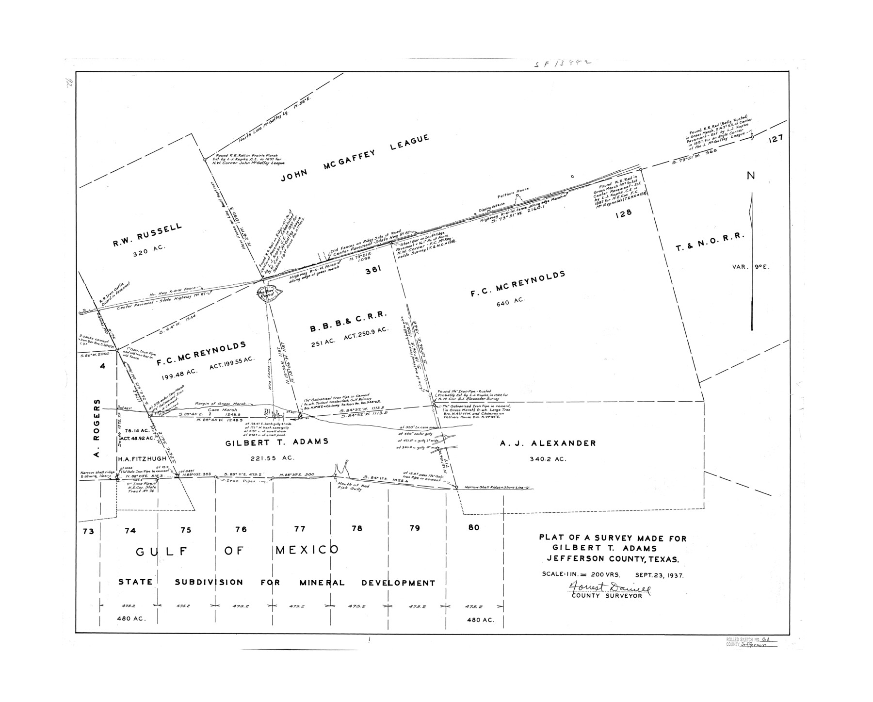
Jefferson County Rolled Sketch GA
Plat of a survey made for Gilbert T. Adams
-
Map/Doc
6437
-
Collection
General Map Collection
-
Object Dates
1937/9/23 (Creation Date)
1937/9/28 (File Date)
-
People and Organizations
Forrest Daniell (Surveyor/Engineer)
-
Counties
Jefferson
-
Subjects
Surveying Rolled Sketch
-
Height x Width
29.5 x 36.7 inches
74.9 x 93.2 cm
-
Scale
1" = 200 varas
Part of: General Map Collection
Houston & Texas Central Railway Through Bastrop County

Print $40.00
- Digital $50.00
Houston & Texas Central Railway Through Bastrop County
1916
Size 21.3 x 116.5 inches
Map/Doc 64418
Walker County Sketch File 2

Print $6.00
- Digital $50.00
Walker County Sketch File 2
1854
Size 10.5 x 15.9 inches
Map/Doc 39549
Galveston County NRC Article 33.136 Sketch 54

Print $22.00
- Digital $50.00
Galveston County NRC Article 33.136 Sketch 54
2008
Size 24.0 x 36.0 inches
Map/Doc 94848
Culberson County Rolled Sketch 48

Print $335.00
- Digital $50.00
Culberson County Rolled Sketch 48
1960
Size 11.0 x 15.4 inches
Map/Doc 45339
Falls County Working Sketch 1

Print $20.00
- Digital $50.00
Falls County Working Sketch 1
1922
Size 23.0 x 33.1 inches
Map/Doc 69176
Lamb County Boundary File 1d

Print $6.00
- Digital $50.00
Lamb County Boundary File 1d
Size 10.2 x 8.2 inches
Map/Doc 56051
Lavaca County Working Sketch 23

Print $20.00
- Digital $50.00
Lavaca County Working Sketch 23
1985
Size 37.8 x 39.8 inches
Map/Doc 70376
Map of the Central and Montgomery Railroad

Print $20.00
- Digital $50.00
Map of the Central and Montgomery Railroad
1881
Size 12.6 x 36.8 inches
Map/Doc 64141
[Galveston, Harrisburg & San Antonio Railroad from Cuero to Stockdale]
![64187, [Galveston, Harrisburg & San Antonio Railroad from Cuero to Stockdale], General Map Collection](https://historictexasmaps.com/wmedia_w700/maps/64187.tif.jpg)
Print $20.00
- Digital $50.00
[Galveston, Harrisburg & San Antonio Railroad from Cuero to Stockdale]
1906
Size 13.3 x 32.9 inches
Map/Doc 64187
Anderson County Boundary File 7

Print $10.00
- Digital $50.00
Anderson County Boundary File 7
Size 14.4 x 8.9 inches
Map/Doc 49751
Moore County Working Sketch 13

Print $40.00
- Digital $50.00
Moore County Working Sketch 13
1967
Size 38.2 x 87.5 inches
Map/Doc 71195
Webb County Working Sketch 46

Print $20.00
- Digital $50.00
Webb County Working Sketch 46
1947
Size 18.4 x 23.5 inches
Map/Doc 72411
You may also like
Comal County Sketch File 10

Print $4.00
- Digital $50.00
Comal County Sketch File 10
1849
Size 12.7 x 7.6 inches
Map/Doc 19020
General Highway Map, Concho County, Texas

Print $20.00
- Digital $50.00
General Highway Map, Concho County, Texas
1954
Size 18.7 x 25.8 inches
Map/Doc 92551
Starr County Sketch File 45

Print $6.00
- Digital $50.00
Starr County Sketch File 45
1945
Size 14.3 x 8.7 inches
Map/Doc 36999
Jasper County Working Sketch 15

Print $20.00
- Digital $50.00
Jasper County Working Sketch 15
1925
Size 26.8 x 22.1 inches
Map/Doc 66477
Duval County Working Sketch 58

Print $20.00
- Digital $50.00
Duval County Working Sketch 58
Size 21.0 x 33.0 inches
Map/Doc 67498
San Patricio County Rolled Sketch 37

Print $127.00
- Digital $50.00
San Patricio County Rolled Sketch 37
Size 10.3 x 15.2 inches
Map/Doc 48888
Jim Wells County Boundary File 3

Print $10.00
- Digital $50.00
Jim Wells County Boundary File 3
Size 9.3 x 6.0 inches
Map/Doc 55546
Pecos County Rolled Sketch 110

Print $20.00
- Digital $50.00
Pecos County Rolled Sketch 110
Size 29.1 x 30.4 inches
Map/Doc 7255

Reagan County Sketch File 22

Print $6.00
- Digital $50.00
Reagan County Sketch File 22
1939
Size 11.4 x 8.9 inches
Map/Doc 35013
Controlled Mosaic by Jack Amman Photogrammetric Engineers, Inc - Sheet 14

Print $20.00
- Digital $50.00
Controlled Mosaic by Jack Amman Photogrammetric Engineers, Inc - Sheet 14
1954
Size 20.0 x 24.0 inches
Map/Doc 83458
Flight Mission No. DAG-23K, Frame 152, Matagorda County

Print $20.00
- Digital $50.00
Flight Mission No. DAG-23K, Frame 152, Matagorda County
1953
Size 15.9 x 15.9 inches
Map/Doc 86500