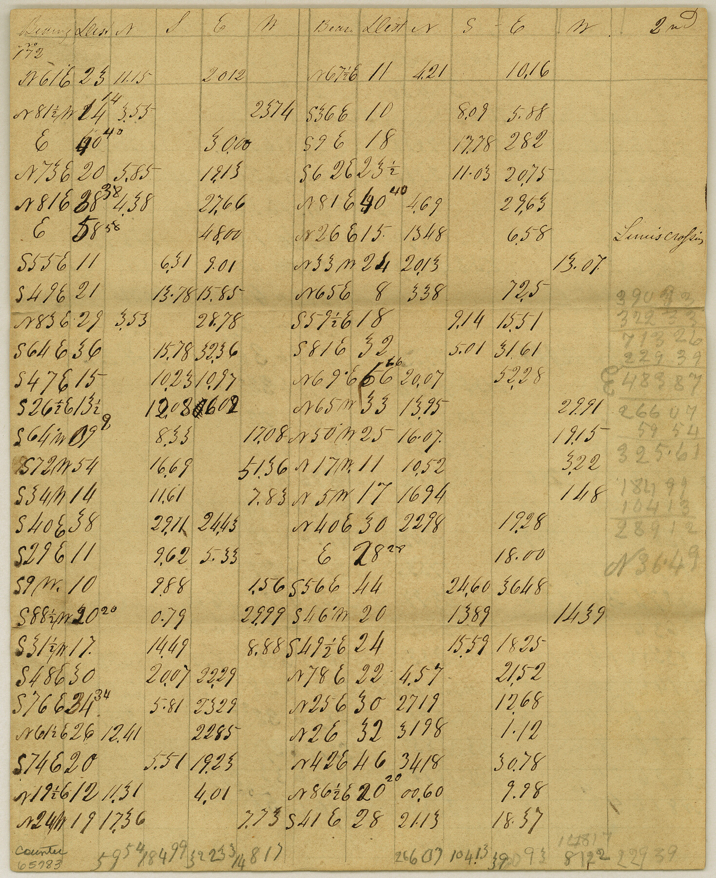
Meanders of Sulphur Fork of Red River, Red River County, Texas
K-3-7
-
Map/Doc
65783
-
Collection
General Map Collection
-
Object Dates
1841 (Creation Date)
-
Counties
Red River
-
Subjects
River Surveys
-
Height x Width
9.9 x 8.1 inches
25.1 x 20.6 cm
Part of: General Map Collection
McMullen County Working Sketch 26

Print $20.00
- Digital $50.00
McMullen County Working Sketch 26
1953
Size 17.8 x 14.5 inches
Map/Doc 70727

Flight Mission No. BRE-1P, Frame 29, Nueces County

Print $20.00
- Digital $50.00
Flight Mission No. BRE-1P, Frame 29, Nueces County
1956
Size 18.4 x 22.5 inches
Map/Doc 86625
Map of Silverton, County Seat of Briscoe County, Texas

Print $20.00
- Digital $50.00
Map of Silverton, County Seat of Briscoe County, Texas
1891
Size 24.3 x 19.8 inches
Map/Doc 4832
Map of Hill County

Print $20.00
- Digital $50.00
Map of Hill County
1884
Size 47.2 x 36.8 inches
Map/Doc 16851
Hunt County Working Sketch 1

Print $20.00
- Digital $50.00
Hunt County Working Sketch 1
Size 18.2 x 17.2 inches
Map/Doc 66348
Flight Mission No. CLL-3N, Frame 36, Willacy County

Print $20.00
- Digital $50.00
Flight Mission No. CLL-3N, Frame 36, Willacy County
1954
Size 18.4 x 22.2 inches
Map/Doc 87094
Medina County Sketch File 6

Print $22.00
- Digital $50.00
Medina County Sketch File 6
1874
Size 8.4 x 12.0 inches
Map/Doc 31454
Montgomery County Rolled Sketch 26

Print $40.00
- Digital $50.00
Montgomery County Rolled Sketch 26
Size 50.0 x 65.4 inches
Map/Doc 9535
Flight Mission No. DCL-6C, Frame 51, Kenedy County

Print $20.00
- Digital $50.00
Flight Mission No. DCL-6C, Frame 51, Kenedy County
1943
Size 18.6 x 22.4 inches
Map/Doc 85893
Cottle County Sketch File 6c

Print $8.00
- Digital $50.00
Cottle County Sketch File 6c
Size 14.2 x 8.6 inches
Map/Doc 19480
Edwards County Sketch File 26

Print $4.00
- Digital $50.00
Edwards County Sketch File 26
1910
Size 11.5 x 9.2 inches
Map/Doc 21753
You may also like
Jack County Sketch File 10

Print $4.00
- Digital $50.00
Jack County Sketch File 10
1857
Size 12.4 x 8.3 inches
Map/Doc 27527
Garden City, Tom Green County, Texas, Section 5, Range 4-S Block 33

Print $3.00
- Digital $50.00
Garden City, Tom Green County, Texas, Section 5, Range 4-S Block 33
1886
Size 10.0 x 16.6 inches
Map/Doc 92130
Flight Mission No. DIX-10P, Frame 165, Aransas County

Print $20.00
- Digital $50.00
Flight Mission No. DIX-10P, Frame 165, Aransas County
1956
Size 18.6 x 22.3 inches
Map/Doc 83955
Webb County Sketch File 70

Print $26.00
- Digital $50.00
Webb County Sketch File 70
Size 11.4 x 8.9 inches
Map/Doc 39875
Sketch of Sabine Lake and Pass

Print $20.00
- Digital $50.00
Sketch of Sabine Lake and Pass
1840
Size 24.8 x 18.2 inches
Map/Doc 72725
General Highway Map, Brazoria County, Texas

Print $20.00
General Highway Map, Brazoria County, Texas
1939
Size 18.4 x 24.9 inches
Map/Doc 79025
Bandera County Working Sketch 13

Print $20.00
- Digital $50.00
Bandera County Working Sketch 13
1932
Size 29.1 x 25.3 inches
Map/Doc 67606
Right of Way San Antonio and Aransas Pass Railway

Print $4.00
- Digital $50.00
Right of Way San Antonio and Aransas Pass Railway
1919
Size 11.6 x 18.5 inches
Map/Doc 62561
Current Miscellaneous File 24a

Print $8.00
- Digital $50.00
Current Miscellaneous File 24a
1949
Size 11.0 x 8.6 inches
Map/Doc 73893
Baylor County Working Sketch 1

Print $20.00
- Digital $50.00
Baylor County Working Sketch 1
1912
Size 19.9 x 12.7 inches
Map/Doc 67286
Randall County Rolled Sketch 9

Print $20.00
- Digital $50.00
Randall County Rolled Sketch 9
Size 47.5 x 35.8 inches
Map/Doc 9808
Arnold Durham Irrigated Farm West Half Section 60, Block 20

Print $20.00
- Digital $50.00
Arnold Durham Irrigated Farm West Half Section 60, Block 20
1945
Size 16.5 x 31.4 inches
Map/Doc 92316