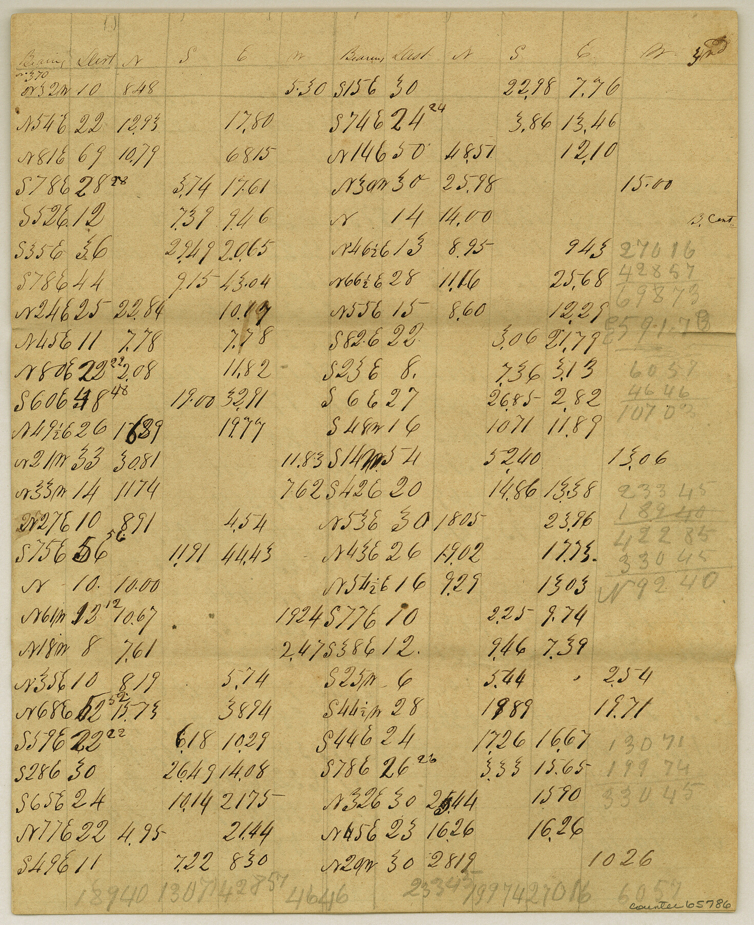
Meanders of Sulphur Fork of Red River, Red River County, Texas
K-3-7
-
Map/Doc
65786
-
Collection
General Map Collection
-
Object Dates
1841 (Creation Date)
-
Counties
Red River
-
Subjects
River Surveys
-
Height x Width
10.0 x 8.1 inches
25.4 x 20.6 cm
Part of: General Map Collection
Flight Mission No. DQO-1K, Frame 92, Galveston County

Print $20.00
- Digital $50.00
Flight Mission No. DQO-1K, Frame 92, Galveston County
1952
Size 18.9 x 22.6 inches
Map/Doc 84988
Flight Mission No. DIX-7P, Frame 20, Aransas County

Print $20.00
- Digital $50.00
Flight Mission No. DIX-7P, Frame 20, Aransas County
1956
Size 18.8 x 22.5 inches
Map/Doc 83872
Hydograhic Survey H-994, Corpus Christi Pass

Print $40.00
- Digital $50.00
Hydograhic Survey H-994, Corpus Christi Pass
1869
Size 31.8 x 53.7 inches
Map/Doc 2701
La Salle County Rolled Sketch 29

Print $20.00
- Digital $50.00
La Salle County Rolled Sketch 29
1984
Size 17.9 x 17.3 inches
Map/Doc 6589
Prison Property, Walker Co.

Print $20.00
- Digital $50.00
Prison Property, Walker Co.
Size 24.4 x 23.5 inches
Map/Doc 62976
Texas-United States Boundary Line 5

Print $68.00
- Digital $50.00
Texas-United States Boundary Line 5
1997
Size 9.6 x 6.4 inches
Map/Doc 74994
Cameron County Rolled Sketch 25

Print $20.00
- Digital $50.00
Cameron County Rolled Sketch 25
1977
Size 24.8 x 36.8 inches
Map/Doc 5792
Mitchell County Working Sketch 3

Print $20.00
- Digital $50.00
Mitchell County Working Sketch 3
1925
Size 30.4 x 33.9 inches
Map/Doc 71060
Briscoe County Sketch File P

Print $40.00
- Digital $50.00
Briscoe County Sketch File P
Size 23.1 x 34.0 inches
Map/Doc 11014
Travis County Appraisal District Plat Map 2_3215

Print $20.00
- Digital $50.00
Travis County Appraisal District Plat Map 2_3215
Size 21.5 x 26.4 inches
Map/Doc 94222
Jackson County Sketch File 14

Print $40.00
- Digital $50.00
Jackson County Sketch File 14
Size 22.2 x 9.8 inches
Map/Doc 27660
Flight Mission No. DAG-18K, Frame 182, Matagorda County

Print $20.00
- Digital $50.00
Flight Mission No. DAG-18K, Frame 182, Matagorda County
1952
Size 17.2 x 22.3 inches
Map/Doc 86374
You may also like
Dawson County Working Sketch 14

Print $20.00
- Digital $50.00
Dawson County Working Sketch 14
1952
Size 15.5 x 12.8 inches
Map/Doc 68558
Flight Mission No. CGI-2N, Frame 187, Cameron County

Print $20.00
- Digital $50.00
Flight Mission No. CGI-2N, Frame 187, Cameron County
1954
Size 18.5 x 22.2 inches
Map/Doc 84547
Harris County Working Sketch 106

Print $40.00
- Digital $50.00
Harris County Working Sketch 106
1981
Size 48.0 x 25.0 inches
Map/Doc 65998
Jeff Davis County Rolled Sketch 1

Print $20.00
- Digital $50.00
Jeff Davis County Rolled Sketch 1
1882
Size 23.0 x 43.2 inches
Map/Doc 6359
Sutton County Sketch File 23

Print $30.00
- Digital $50.00
Sutton County Sketch File 23
1918
Size 14.2 x 8.5 inches
Map/Doc 37461
Gillespie County Rolled Sketch 8

Print $20.00
- Digital $50.00
Gillespie County Rolled Sketch 8
2008
Size 20.2 x 19.1 inches
Map/Doc 89014
Sherman County, Texas

Print $20.00
- Digital $50.00
Sherman County, Texas
Size 19.1 x 18.8 inches
Map/Doc 753
Eastland County Working Sketch 58

Print $20.00
- Digital $50.00
Eastland County Working Sketch 58
1985
Size 25.5 x 39.6 inches
Map/Doc 68839
Map of Ramon Musquiz Survey, Meanders of Lavaca & Navidad Rivers, Menefee & Redfish Lakes

Print $20.00
- Digital $50.00
Map of Ramon Musquiz Survey, Meanders of Lavaca & Navidad Rivers, Menefee & Redfish Lakes
1934
Size 24.4 x 18.0 inches
Map/Doc 65453
United States - Gulf Coast Texas - Southern part of Laguna Madre

Print $20.00
- Digital $50.00
United States - Gulf Coast Texas - Southern part of Laguna Madre
1941
Size 26.4 x 18.2 inches
Map/Doc 72939
Flight Mission No. DQN-1K, Frame 129, Calhoun County

Print $20.00
- Digital $50.00
Flight Mission No. DQN-1K, Frame 129, Calhoun County
1953
Size 18.5 x 22.2 inches
Map/Doc 84192
Mapa de los Estados Unidos de Méjico, Segun lo organizado y definido por las varias actas del Congreso de dicha Republica: y construido por las mejores autoridades

Print $20.00
Mapa de los Estados Unidos de Méjico, Segun lo organizado y definido por las varias actas del Congreso de dicha Republica: y construido por las mejores autoridades
1846
Size 30.8 x 42.4 inches
Map/Doc 79727