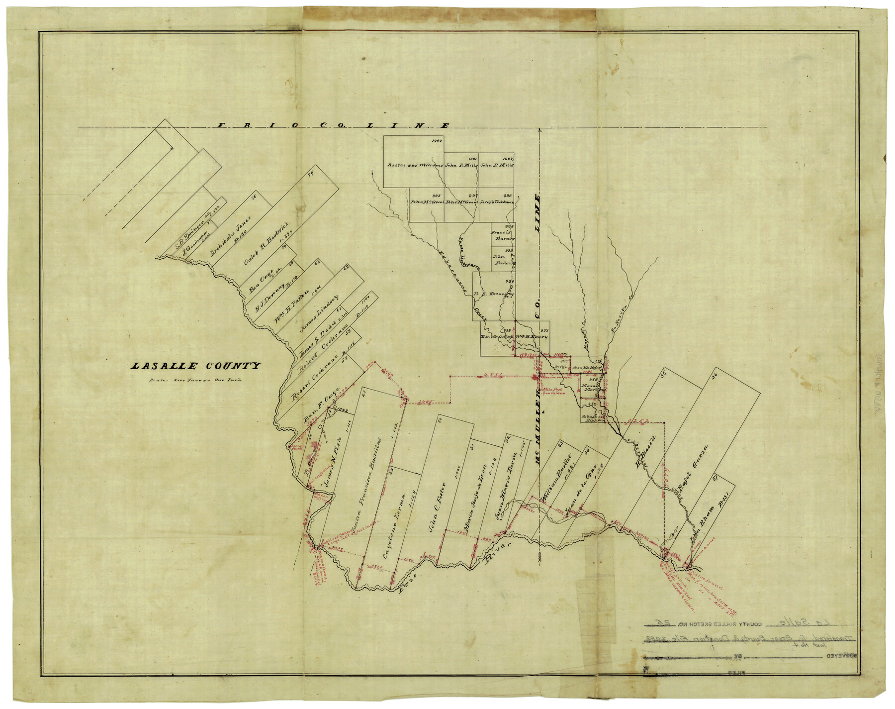
La Salle County Rolled Sketch 25
[Sketch of surveys north of Frio River in northeast part of La Salle County]
-
Map/Doc
6586
-
Collection
General Map Collection
-
Object Dates
4/26/1966 (File Date)
-
Counties
La Salle McMullen
-
Subjects
Surveying Rolled Sketch
-
Height x Width
20.3 x 24.4 inches
51.6 x 62.0 cm
-
Medium
linen, manuscript
-
Scale
1" = 2000 varas
-
Comments
Transferred from Bexar B-2092.
Part of: General Map Collection
McMullen County Sketch File 15

Print $4.00
- Digital $50.00
McMullen County Sketch File 15
1876
Size 10.0 x 8.0 inches
Map/Doc 31363

El Paso County Working Sketch 40

Print $20.00
- Digital $50.00
El Paso County Working Sketch 40
1992
Size 21.5 x 24.0 inches
Map/Doc 69062
Mills County Working Sketch 24

Print $20.00
- Digital $50.00
Mills County Working Sketch 24
1988
Size 40.3 x 36.5 inches
Map/Doc 71054
Map of Jack County

Print $20.00
- Digital $50.00
Map of Jack County
Size 18.4 x 15.9 inches
Map/Doc 3702
Gonzales County Boundary File 1b

Print $52.00
- Digital $50.00
Gonzales County Boundary File 1b
Size 8.0 x 5.0 inches
Map/Doc 53803
Flight Mission No. DQO-2K, Frame 101, Galveston County

Print $20.00
- Digital $50.00
Flight Mission No. DQO-2K, Frame 101, Galveston County
1952
Size 18.8 x 22.5 inches
Map/Doc 85028
Real County Working Sketch 61

Print $20.00
- Digital $50.00
Real County Working Sketch 61
1964
Size 37.9 x 44.5 inches
Map/Doc 71953
Franklin County Sketch File 1c

Print $4.00
- Digital $50.00
Franklin County Sketch File 1c
1853
Size 10.3 x 8.1 inches
Map/Doc 23010
Jefferson County Sketch File 33

Print $32.00
- Digital $50.00
Jefferson County Sketch File 33
1934
Size 8.2 x 7.6 inches
Map/Doc 28197
Wise County Sketch File 13

Print $4.00
- Digital $50.00
Wise County Sketch File 13
Size 9.0 x 15.2 inches
Map/Doc 40546
Polk County Working Sketch 26

Print $20.00
- Digital $50.00
Polk County Working Sketch 26
1958
Size 19.0 x 24.8 inches
Map/Doc 71642
You may also like
Jefferson County Sketch File 42

Print $20.00
- Digital $50.00
Jefferson County Sketch File 42
1945
Size 25.5 x 35.1 inches
Map/Doc 11876
El Paso County Rolled Sketch 38
Print $40.00
- Digital $50.00
El Paso County Rolled Sketch 38
1922
Size 14.1 x 61.3 inches
Map/Doc 8866
[Sketch of Block A1 in Hartley County]
![90762, [Sketch of Block A1 in Hartley County], Twichell Survey Records](https://historictexasmaps.com/wmedia_w700/maps/90762-1.tif.jpg)
Print $20.00
- Digital $50.00
[Sketch of Block A1 in Hartley County]
1902
Size 11.3 x 21.4 inches
Map/Doc 90762
Proceedings of The International (Water) Boundary Commission United States and Mexico Treaties of 1884 and 1889, Volume 2

Proceedings of The International (Water) Boundary Commission United States and Mexico Treaties of 1884 and 1889, Volume 2
Map/Doc 83145
Gregg County Sketch File 13

Print $32.00
- Digital $50.00
Gregg County Sketch File 13
1934
Size 13.9 x 8.7 inches
Map/Doc 24597
Foard County Working Sketch 10

Print $20.00
- Digital $50.00
Foard County Working Sketch 10
1977
Size 32.0 x 43.7 inches
Map/Doc 69201
[Surveys on Trespalacios Bay]
![19, [Surveys on Trespalacios Bay], General Map Collection](https://historictexasmaps.com/wmedia_w700/maps/19.tif.jpg)
Print $2.00
- Digital $50.00
[Surveys on Trespalacios Bay]
Size 7.2 x 9.6 inches
Map/Doc 19
Map of Cooke County

Print $20.00
- Digital $50.00
Map of Cooke County
1857
Size 34.1 x 37.9 inches
Map/Doc 1973
Jack County Sketch File 11

Print $4.00
- Digital $50.00
Jack County Sketch File 11
1858
Size 10.2 x 8.1 inches
Map/Doc 27531
Brown County Sketch File 25

Print $6.00
- Digital $50.00
Brown County Sketch File 25
1890
Size 11.2 x 15.4 inches
Map/Doc 16623
Uvalde County Working Sketch 49

Print $20.00
- Digital $50.00
Uvalde County Working Sketch 49
1980
Size 35.4 x 44.7 inches
Map/Doc 72119
Jackson County Sketch File 21

Print $70.00
- Digital $50.00
Jackson County Sketch File 21
2000
Size 11.3 x 8.8 inches
Map/Doc 27673