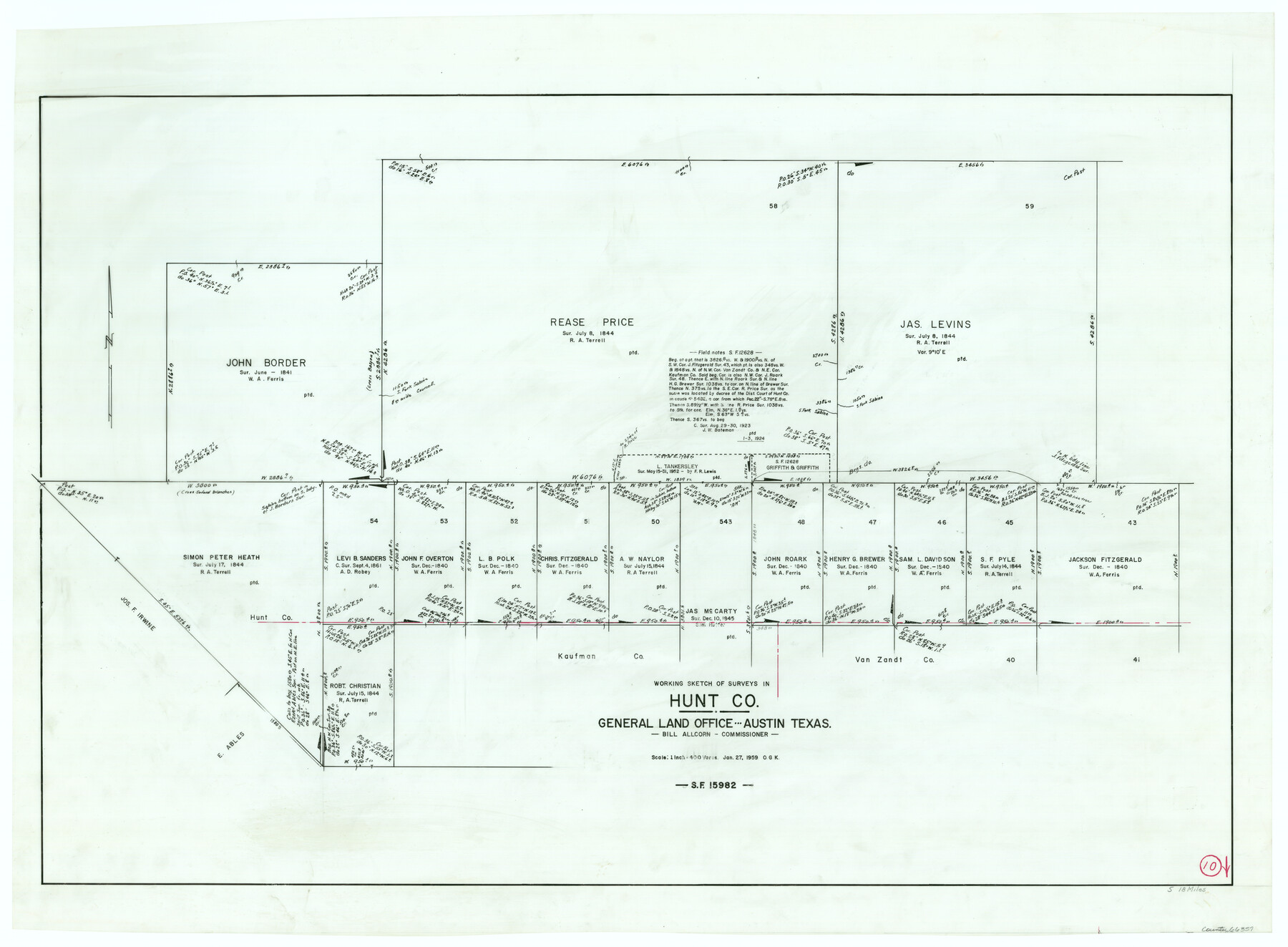
Hunt County Working Sketch 10
-
Map/Doc
66357
-
Collection
General Map Collection
-
Object Dates
1/27/1959 (Creation Date)
-
People and Organizations
Otto G. Kurio (Draftsman)
-
Counties
Hunt
-
Subjects
Surveying Working Sketch
-
Height x Width
31.5 x 42.8 inches
80.0 x 108.7 cm
-
Scale
1" = 400 varas
Part of: General Map Collection
Flight Mission No. CRC-3R, Frame 56, Chambers County

Print $20.00
- Digital $50.00
Flight Mission No. CRC-3R, Frame 56, Chambers County
1956
Size 18.6 x 22.3 inches
Map/Doc 84828
Navarro County Working Sketch 11

Print $40.00
- Digital $50.00
Navarro County Working Sketch 11
1978
Size 53.7 x 44.4 inches
Map/Doc 71241
Jones County Sketch File 16

Print $20.00
- Digital $50.00
Jones County Sketch File 16
1945
Size 23.7 x 19.0 inches
Map/Doc 11901
Kleberg County Rolled Sketch 5

Print $20.00
- Digital $50.00
Kleberg County Rolled Sketch 5
Size 27.8 x 21.8 inches
Map/Doc 6548
Erath County Sketch File 15

Print $4.00
- Digital $50.00
Erath County Sketch File 15
1872
Size 6.2 x 7.6 inches
Map/Doc 22292
Edwards County Rolled Sketch 33

Print $20.00
- Digital $50.00
Edwards County Rolled Sketch 33
1890
Size 25.0 x 25.8 inches
Map/Doc 5815
Flight Mission No. DQN-2K, Frame 137, Calhoun County

Print $20.00
- Digital $50.00
Flight Mission No. DQN-2K, Frame 137, Calhoun County
1953
Size 18.8 x 22.5 inches
Map/Doc 84306
Right of Way & Track Map, St. Louis, Brownsville & Mexico Ry. operated by St. Louis, Brownsville & Mexico Ry. Co.

Print $40.00
- Digital $50.00
Right of Way & Track Map, St. Louis, Brownsville & Mexico Ry. operated by St. Louis, Brownsville & Mexico Ry. Co.
1919
Size 25.4 x 57.1 inches
Map/Doc 64618
Flight Mission No. DIX-6P, Frame 132, Aransas County

Print $20.00
- Digital $50.00
Flight Mission No. DIX-6P, Frame 132, Aransas County
1956
Size 19.3 x 23.2 inches
Map/Doc 83838
Map of Crockett County

Print $40.00
- Digital $50.00
Map of Crockett County
1878
Size 62.6 x 49.7 inches
Map/Doc 93373
San Augustine County Sketch File 4

Print $4.00
San Augustine County Sketch File 4
1849
Size 6.5 x 5.4 inches
Map/Doc 35640
Rusk County Working Sketch 18

Print $20.00
- Digital $50.00
Rusk County Working Sketch 18
1955
Size 32.6 x 28.3 inches
Map/Doc 63653
You may also like
Flight Mission No. DQN-7K, Frame 89, Calhoun County

Print $20.00
- Digital $50.00
Flight Mission No. DQN-7K, Frame 89, Calhoun County
1953
Size 18.4 x 22.2 inches
Map/Doc 84480
Lampasas County Sketch File 9c

Print $4.00
- Digital $50.00
Lampasas County Sketch File 9c
1873
Size 12.7 x 8.1 inches
Map/Doc 29414
Medina County Working Sketch 29

Print $20.00
- Digital $50.00
Medina County Working Sketch 29
Size 40.1 x 25.0 inches
Map/Doc 70944

El Paso County Sketch File 42

Print $16.00
- Digital $50.00
El Paso County Sketch File 42
1996
Size 14.3 x 8.9 inches
Map/Doc 22241
Dallam County Sketch File 4

Print $20.00
- Digital $50.00
Dallam County Sketch File 4
Size 27.7 x 8.5 inches
Map/Doc 11279
Cameron County Aerial Photograph Index Sheet 6

Print $20.00
- Digital $50.00
Cameron County Aerial Photograph Index Sheet 6
1955
Size 20.6 x 14.0 inches
Map/Doc 83678
Houston County Sketch File 5a

Print $5.00
- Digital $50.00
Houston County Sketch File 5a
Size 8.5 x 9.4 inches
Map/Doc 26758
Houston County Sketch File 22

Print $8.00
- Digital $50.00
Houston County Sketch File 22
1852
Size 12.6 x 8.2 inches
Map/Doc 26789
Leon County Working Sketch 61

Print $20.00
- Digital $50.00
Leon County Working Sketch 61
2010
Size 35.8 x 38.7 inches
Map/Doc 89986
Edwards County Working Sketch 19

Print $20.00
- Digital $50.00
Edwards County Working Sketch 19
1934
Size 24.1 x 24.6 inches
Map/Doc 68895
Sutton County Sketch File X

Print $24.00
- Digital $50.00
Sutton County Sketch File X
1915
Size 14.3 x 8.8 inches
Map/Doc 37451