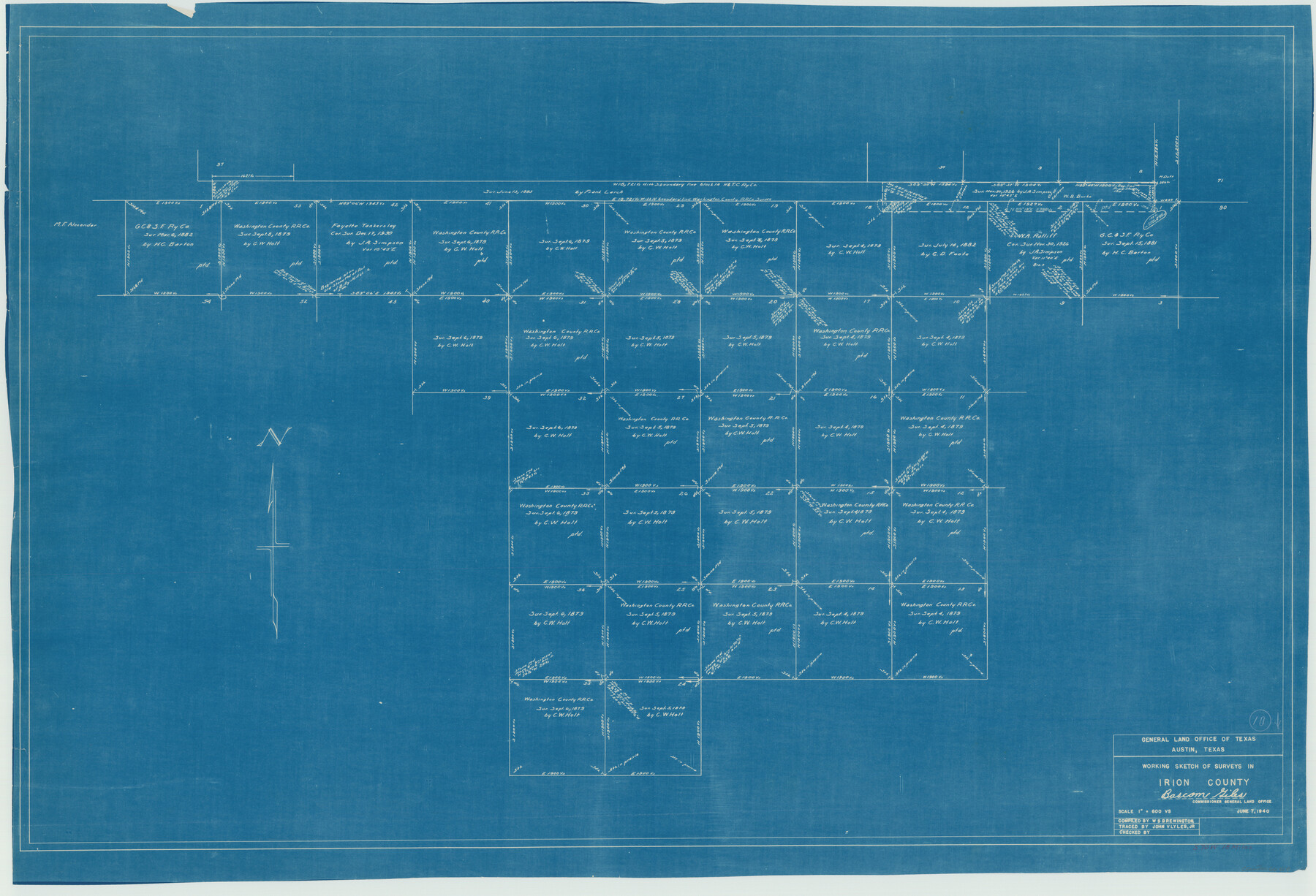
Irion County Working Sketch 10
-
Map/Doc
66419
-
Collection
General Map Collection
-
Object Dates
6/7/1940 (Creation Date)
-
People and Organizations
W. S. Brewington (Compiler)
John V. Lyles, Jr. (Tracer)
-
Counties
Irion
-
Subjects
Surveying Working Sketch
-
Height x Width
29.6 x 43.5 inches
75.2 x 110.5 cm
-
Scale
1" = 600 varas
Part of: General Map Collection
Edwards County Working Sketch 31

Print $20.00
- Digital $50.00
Edwards County Working Sketch 31
1947
Size 33.5 x 47.5 inches
Map/Doc 68907
Flight Mission No. BRA-16M, Frame 101, Jefferson County

Print $20.00
- Digital $50.00
Flight Mission No. BRA-16M, Frame 101, Jefferson County
1953
Size 18.6 x 22.4 inches
Map/Doc 85713
Houston County Sketch File 18a

Print $40.00
- Digital $50.00
Houston County Sketch File 18a
Size 12.7 x 15.9 inches
Map/Doc 26783
San Patricio County Sketch File 10

Print $8.00
San Patricio County Sketch File 10
1847
Size 13.3 x 8.4 inches
Map/Doc 36040
Webb County Working Sketch 66

Print $40.00
- Digital $50.00
Webb County Working Sketch 66
1966
Size 62.8 x 42.5 inches
Map/Doc 72433
[Sketch for Mineral Application 16700 - Pecos River Bed]
![2806, [Sketch for Mineral Application 16700 - Pecos River Bed], General Map Collection](https://historictexasmaps.com/wmedia_w700/maps/2806.tif.jpg)
Print $20.00
- Digital $50.00
[Sketch for Mineral Application 16700 - Pecos River Bed]
1927
Size 20.3 x 29.1 inches
Map/Doc 2806
Midland County Working Sketch 1

Print $20.00
- Digital $50.00
Midland County Working Sketch 1
Size 26.8 x 8.7 inches
Map/Doc 70981
Crockett County Sketch File 39

Print $20.00
- Digital $50.00
Crockett County Sketch File 39
1889
Size 19.7 x 32.6 inches
Map/Doc 11221
Childress County Sketch File 16a

Print $16.00
- Digital $50.00
Childress County Sketch File 16a
1901
Size 13.3 x 8.3 inches
Map/Doc 18309
Throckmorton County Rolled Sketch 3C

Print $20.00
- Digital $50.00
Throckmorton County Rolled Sketch 3C
Size 31.1 x 37.1 inches
Map/Doc 7989
[Galveston, Harrisburg & San Antonio from El Paso-Presidio county boundary to Presidio-Pecos county boundary]
![64716, [Galveston, Harrisburg & San Antonio from El Paso-Presidio county boundary to Presidio-Pecos county boundary], General Map Collection](https://historictexasmaps.com/wmedia_w700/maps/64716.tif.jpg)
Print $40.00
- Digital $50.00
[Galveston, Harrisburg & San Antonio from El Paso-Presidio county boundary to Presidio-Pecos county boundary]
Size 124.4 x 45.3 inches
Map/Doc 64716
Travis County Sketch File 12

Print $4.00
- Digital $50.00
Travis County Sketch File 12
1850
Size 12.7 x 8.2 inches
Map/Doc 38304
You may also like
Aransas County Rolled Sketch 33

Print $20.00
- Digital $50.00
Aransas County Rolled Sketch 33
1997
Size 24.5 x 36.8 inches
Map/Doc 78495
Wilbarger County Working Sketch 12

Print $20.00
- Digital $50.00
Wilbarger County Working Sketch 12
1953
Size 42.2 x 33.5 inches
Map/Doc 72550
[Corpus Christi Bay, Padre Island, Mustang Island, Laguna de la Madre, King and Kenedy's Pasture]
![73046, [Corpus Christi Bay, Padre Island, Mustang Island, Laguna de la Madre, King and Kenedy's Pasture], General Map Collection](https://historictexasmaps.com/wmedia_w700/maps/73046.tif.jpg)
Print $20.00
- Digital $50.00
[Corpus Christi Bay, Padre Island, Mustang Island, Laguna de la Madre, King and Kenedy's Pasture]
Size 26.4 x 18.2 inches
Map/Doc 73046
Wise County Sketch File 29

Print $20.00
- Digital $50.00
Wise County Sketch File 29
1857
Size 11.1 x 20.7 inches
Map/Doc 76762
Bailey County

Print $20.00
- Digital $50.00
Bailey County
1913
Size 29.0 x 22.5 inches
Map/Doc 66708
Kleberg County Aerial Photograph Index Sheet 6

Print $20.00
- Digital $50.00
Kleberg County Aerial Photograph Index Sheet 6
1956
Size 19.3 x 23.5 inches
Map/Doc 83723
[Elizabeth Stanley, William H. Anderson, and surrounding surveys]
![91022, [Elizabeth Stanley, William H. Anderson, and surrounding surveys], Twichell Survey Records](https://historictexasmaps.com/wmedia_w700/maps/91022-1.tif.jpg)
Print $20.00
- Digital $50.00
[Elizabeth Stanley, William H. Anderson, and surrounding surveys]
Size 27.0 x 18.9 inches
Map/Doc 91022
Guadalupe County, Texas

Print $20.00
- Digital $50.00
Guadalupe County, Texas
1880
Size 24.7 x 22.5 inches
Map/Doc 491
Zavala County Rolled Sketch 23

Print $20.00
- Digital $50.00
Zavala County Rolled Sketch 23
1943
Size 17.0 x 25.6 inches
Map/Doc 8326
Brooks County Working Sketch 16

Print $20.00
- Digital $50.00
Brooks County Working Sketch 16
1972
Size 35.0 x 29.7 inches
Map/Doc 67800
Flight Mission No. BQY-4M, Frame 126, Harris County

Print $20.00
- Digital $50.00
Flight Mission No. BQY-4M, Frame 126, Harris County
1953
Size 18.5 x 22.2 inches
Map/Doc 85295
Atascosa County Sketch File 7

Print $4.00
- Digital $50.00
Atascosa County Sketch File 7
Size 8.2 x 6.5 inches
Map/Doc 13756