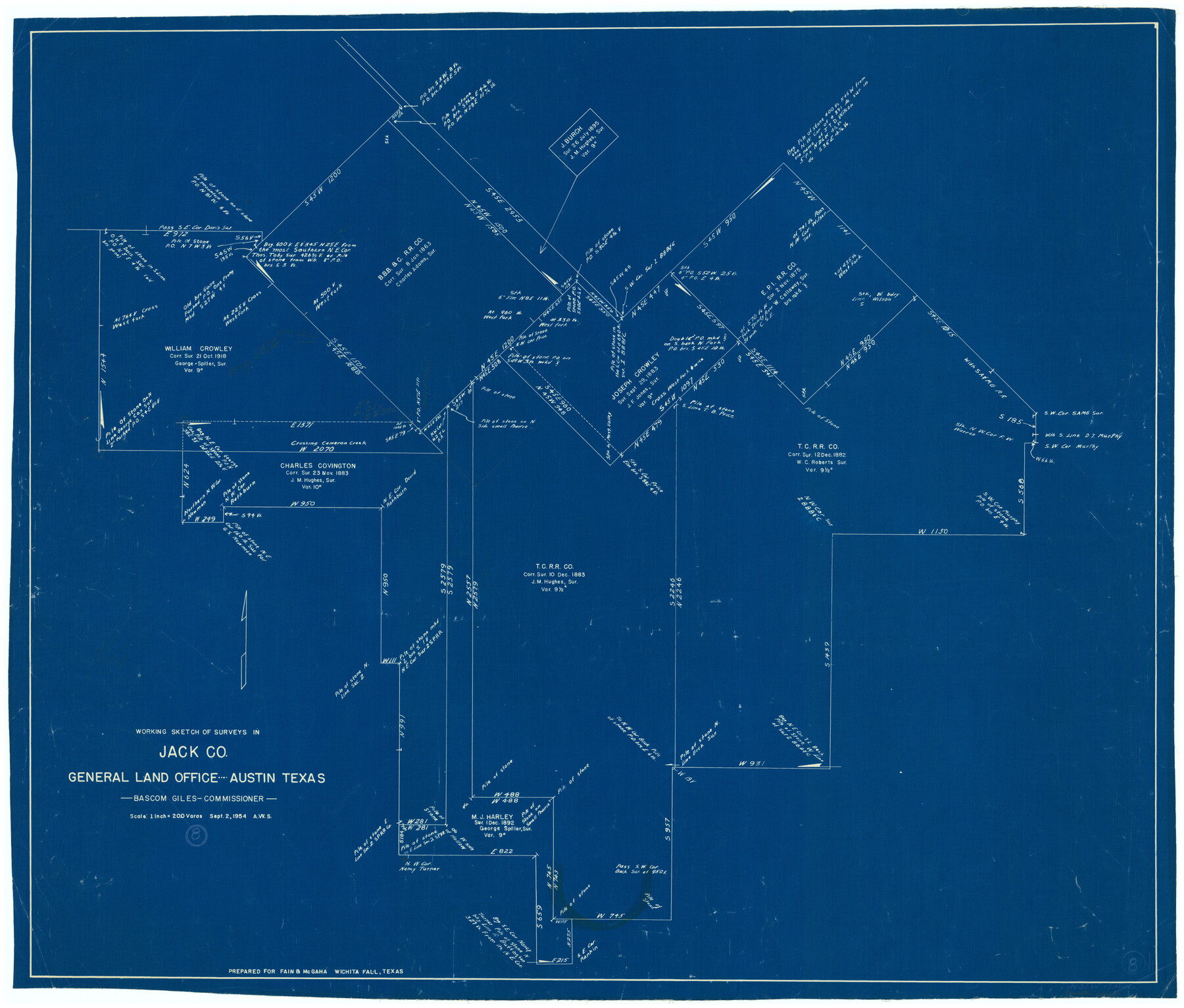
Jack County Working Sketch 8
-
Map/Doc
66434
-
Collection
General Map Collection
-
Object Dates
9/2/1954 (Creation Date)
-
Counties
Jack
-
Subjects
Surveying Working Sketch
-
Height x Width
30.5 x 35.9 inches
77.5 x 91.2 cm
-
Scale
1" = 200 varas
Part of: General Map Collection
Gulf of Mexico

Print $20.00
- Digital $50.00
Gulf of Mexico
1961
Size 36.6 x 43.3 inches
Map/Doc 73551
Cottle County Rolled Sketch OX

Print $20.00
- Digital $50.00
Cottle County Rolled Sketch OX
1916
Size 29.6 x 35.8 inches
Map/Doc 8673
Flight Mission No. BQR-9K, Frame 10, Brazoria County

Print $20.00
- Digital $50.00
Flight Mission No. BQR-9K, Frame 10, Brazoria County
1952
Size 18.7 x 22.3 inches
Map/Doc 84039
Flight Mission No. DQO-6K, Frame 20, Galveston County

Print $20.00
- Digital $50.00
Flight Mission No. DQO-6K, Frame 20, Galveston County
1952
Size 18.8 x 22.3 inches
Map/Doc 85093
Newton County Sketch File 4c

Print $4.00
- Digital $50.00
Newton County Sketch File 4c
Size 7.4 x 8.2 inches
Map/Doc 32366
Navigation Maps of Gulf Intracoastal Waterway, Port Arthur to Brownsville, Texas

Print $4.00
- Digital $50.00
Navigation Maps of Gulf Intracoastal Waterway, Port Arthur to Brownsville, Texas
1951
Size 16.7 x 21.2 inches
Map/Doc 65449
Nueces County Sketch File 16

Print $6.00
- Digital $50.00
Nueces County Sketch File 16
1875
Size 15.5 x 10.7 inches
Map/Doc 32547
Kendall County Sketch File 1

Print $4.00
- Digital $50.00
Kendall County Sketch File 1
Size 9.6 x 8.3 inches
Map/Doc 28671
[Surveys on the Sabine River, Sulphur Fork of the Red River, and the Bois d'Arc River for Johnson, Williams, and Peebles' contract and G. W. Smyth, commissioner]
![44, [Surveys on the Sabine River, Sulphur Fork of the Red River, and the Bois d'Arc River for Johnson, Williams, and Peebles' contract and G. W. Smyth, commissioner], General Map Collection](https://historictexasmaps.com/wmedia_w700/maps/44-1.tif.jpg)
Print $20.00
- Digital $50.00
[Surveys on the Sabine River, Sulphur Fork of the Red River, and the Bois d'Arc River for Johnson, Williams, and Peebles' contract and G. W. Smyth, commissioner]
1835
Size 23.6 x 25.9 inches
Map/Doc 44
Harris County Rolled Sketch 96A

Print $20.00
- Digital $50.00
Harris County Rolled Sketch 96A
Size 45.7 x 37.7 inches
Map/Doc 9143

Roberts County Working Sketch 9

Print $20.00
- Digital $50.00
Roberts County Working Sketch 9
1964
Size 24.3 x 36.5 inches
Map/Doc 63535
You may also like
Eastland County Sketch File 5

Print $4.00
- Digital $50.00
Eastland County Sketch File 5
Size 6.4 x 7.1 inches
Map/Doc 21570
Reeves County Working Sketch 53

Print $40.00
- Digital $50.00
Reeves County Working Sketch 53
1977
Size 70.3 x 42.6 inches
Map/Doc 63496
Hamilton County Working Sketch 18

Print $20.00
- Digital $50.00
Hamilton County Working Sketch 18
1952
Size 22.4 x 25.1 inches
Map/Doc 63356
Robertson County Rolled Sketch 1A

Print $20.00
- Digital $50.00
Robertson County Rolled Sketch 1A
1966
Size 45.3 x 28.1 inches
Map/Doc 9863
Panola County Working Sketch 11

Print $20.00
- Digital $50.00
Panola County Working Sketch 11
1944
Map/Doc 71420
Live Oak County Sketch File 34

Print $28.00
- Digital $50.00
Live Oak County Sketch File 34
1963
Size 31.0 x 23.9 inches
Map/Doc 12011
Aransas County NRC Article 33.136 Sketch 16

Print $24.00
- Digital $50.00
Aransas County NRC Article 33.136 Sketch 16
Size 24.0 x 36.0 inches
Map/Doc 95381
Bosque County Sketch File 31

Print $6.00
- Digital $50.00
Bosque County Sketch File 31
1867
Size 8.5 x 10.5 inches
Map/Doc 14830
Gonzales County Boundary File 2

Print $7.00
- Digital $50.00
Gonzales County Boundary File 2
Size 14.4 x 9.0 inches
Map/Doc 53829
America with those known parts in that unknowne worlde both people and manner of buildings

Print $20.00
- Digital $50.00
America with those known parts in that unknowne worlde both people and manner of buildings
1626
Size 17.1 x 22.2 inches
Map/Doc 93816

Flight Mission No. DAG-28K, Frame 23, Matagorda County

Print $20.00
- Digital $50.00
Flight Mission No. DAG-28K, Frame 23, Matagorda County
1953
Size 18.6 x 22.5 inches
Map/Doc 86591