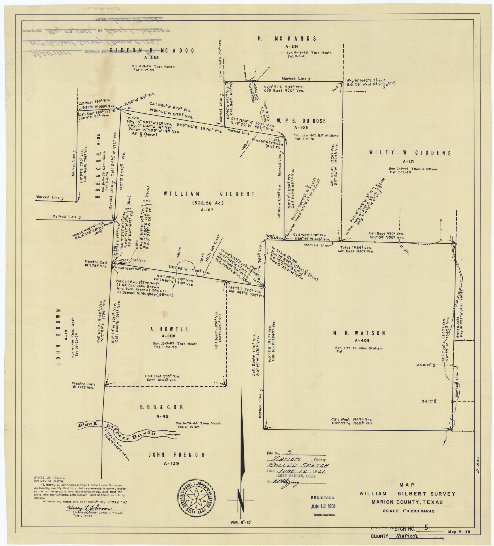
Marion County Rolled Sketch 5
Map, William Gilbert survey, Marion County, Texas
-
Map/Doc
6658
-
Collection
General Map Collection
-
Object Dates
1961/6/12 (File Date)
1961/5/29 (Creation Date)
-
People and Organizations
Harry L. Johnson (Surveyor/Engineer)
-
Counties
Marion
-
Subjects
Surveying Rolled Sketch
-
Height x Width
22.6 x 20.5 inches
57.4 x 52.1 cm
-
Medium
paper, manuscript
-
Scale
1" = 200 varas
Part of: General Map Collection
Young County Boundary File 1

Print $8.00
- Digital $50.00
Young County Boundary File 1
Size 10.3 x 8.2 inches
Map/Doc 60198
Shelby County Working Sketch 10

Print $20.00
- Digital $50.00
Shelby County Working Sketch 10
1945
Size 42.8 x 43.9 inches
Map/Doc 63863
Flight Mission No. DQO-2K, Frame 102, Galveston County

Print $20.00
- Digital $50.00
Flight Mission No. DQO-2K, Frame 102, Galveston County
1952
Size 18.8 x 22.5 inches
Map/Doc 85029
Flight Mission No. CRC-1R, Frame 94, Chambers County

Print $20.00
- Digital $50.00
Flight Mission No. CRC-1R, Frame 94, Chambers County
1956
Size 18.8 x 22.5 inches
Map/Doc 84709
Zapata County Boundary File 1

Print $2.00
- Digital $50.00
Zapata County Boundary File 1
Size 11.4 x 9.0 inches
Map/Doc 60227
Travis County Rolled Sketch 21

Print $20.00
- Digital $50.00
Travis County Rolled Sketch 21
1941
Size 16.2 x 14.7 inches
Map/Doc 8022
Flight Mission No. BRA-7M, Frame 185, Jefferson County

Print $20.00
- Digital $50.00
Flight Mission No. BRA-7M, Frame 185, Jefferson County
1953
Size 18.6 x 22.3 inches
Map/Doc 85553
Presidio County Working Sketch 63

Print $40.00
- Digital $50.00
Presidio County Working Sketch 63
1958
Size 64.8 x 38.9 inches
Map/Doc 71740
Falls County Rolled Sketch 1

Print $73.00
- Digital $50.00
Falls County Rolled Sketch 1
1934
Size 10.6 x 15.1 inches
Map/Doc 44540
Central Part of Jeff Davis Co.

Print $40.00
- Digital $50.00
Central Part of Jeff Davis Co.
1982
Size 56.3 x 43.9 inches
Map/Doc 95543
Right of Way and Track Map of The Missouri, Kansas & Texas Railway of Texas

Print $40.00
- Digital $50.00
Right of Way and Track Map of The Missouri, Kansas & Texas Railway of Texas
1918
Size 25.2 x 51.6 inches
Map/Doc 64530
Flight Mission No. BRE-2P, Frame 96, Nueces County

Print $20.00
- Digital $50.00
Flight Mission No. BRE-2P, Frame 96, Nueces County
1956
Size 18.4 x 22.3 inches
Map/Doc 86781
You may also like
Concho County Sketch File 8 1/4

Print $20.00
- Digital $50.00
Concho County Sketch File 8 1/4
Size 23.4 x 15.0 inches
Map/Doc 11149
Williamson County Sketch File 21

Print $4.00
- Digital $50.00
Williamson County Sketch File 21
1893
Size 11.3 x 8.7 inches
Map/Doc 40350
Val Verde County Rolled Sketch 61

Print $20.00
- Digital $50.00
Val Verde County Rolled Sketch 61
1938
Size 27.3 x 24.2 inches
Map/Doc 8128
Edwards County Working Sketch 76

Print $20.00
- Digital $50.00
Edwards County Working Sketch 76
1959
Size 22.8 x 24.8 inches
Map/Doc 68952
Wharton County Sketch File 17

Print $12.00
- Digital $50.00
Wharton County Sketch File 17
1898
Size 12.8 x 8.1 inches
Map/Doc 39969
Grayson County Boundary File 3a

Print $25.00
- Digital $50.00
Grayson County Boundary File 3a
Size 8.3 x 16.9 inches
Map/Doc 53945
Austin and Surrounding Properties
.tif.jpg)
Print $20.00
- Digital $50.00
Austin and Surrounding Properties
1891
Size 42.9 x 32.1 inches
Map/Doc 421
Atascosa County Working Sketch 25

Print $20.00
- Digital $50.00
Atascosa County Working Sketch 25
1958
Size 38.2 x 44.0 inches
Map/Doc 67221
Deaf Smith County Sketch File Z

Print $34.00
- Digital $50.00
Deaf Smith County Sketch File Z
1903
Size 9.6 x 4.7 inches
Map/Doc 20651
Tarrant County Sketch File 10a

Print $6.00
- Digital $50.00
Tarrant County Sketch File 10a
1860
Size 10.3 x 8.1 inches
Map/Doc 37691
Mills County Sketch File 18A

Print $20.00
- Digital $50.00
Mills County Sketch File 18A
1913
Size 26.5 x 18.4 inches
Map/Doc 12093
Fractional Township No. 7 South Range No. 6 East of the Indian Meridian, Indian Territory

Print $20.00
- Digital $50.00
Fractional Township No. 7 South Range No. 6 East of the Indian Meridian, Indian Territory
1898
Size 19.2 x 24.3 inches
Map/Doc 75211