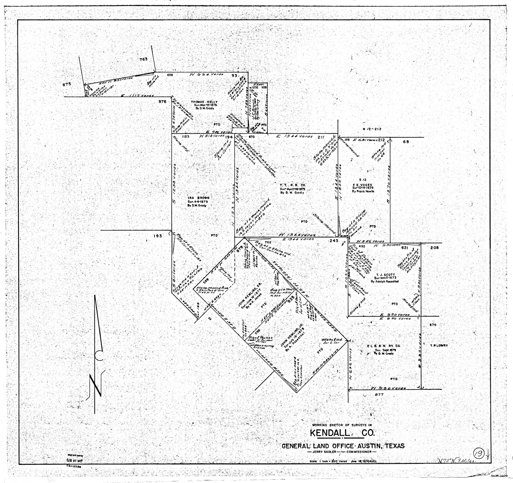
Kendall County Working Sketch 19
-
Map/Doc
66691
-
Collection
General Map Collection
-
Object Dates
6/19/1970 (Creation Date)
-
People and Organizations
Herbert H. Ulbricht (Draftsman)
-
Counties
Kendall
-
Subjects
Surveying Working Sketch
-
Height x Width
31.5 x 33.4 inches
80.0 x 84.8 cm
-
Scale
1" = 200 varas
Part of: General Map Collection
La Salle County Sketch File 35

Print $40.00
- Digital $50.00
La Salle County Sketch File 35
Size 12.1 x 19.7 inches
Map/Doc 29587
Mitchell County

Print $20.00
- Digital $50.00
Mitchell County
1880
Size 26.2 x 23.5 inches
Map/Doc 3883
Bosque County Sketch File 14

Print $22.00
- Digital $50.00
Bosque County Sketch File 14
1863
Size 12.2 x 7.6 inches
Map/Doc 14763
Hood County Sketch File 10

Print $20.00
- Digital $50.00
Hood County Sketch File 10
Size 20.6 x 22.9 inches
Map/Doc 11778
Kerr County Rolled Sketch 11

Print $20.00
- Digital $50.00
Kerr County Rolled Sketch 11
1950
Size 28.1 x 36.9 inches
Map/Doc 6495
San Antonio and Aransas Pass Ry. from Survey Station 4852+100 to Survey Station 5280+00

Print $4.00
- Digital $50.00
San Antonio and Aransas Pass Ry. from Survey Station 4852+100 to Survey Station 5280+00
Size 11.8 x 18.6 inches
Map/Doc 62570
Brown County Working Sketch 15

Print $20.00
- Digital $50.00
Brown County Working Sketch 15
1989
Size 23.6 x 16.7 inches
Map/Doc 67780
Jackson County

Print $20.00
- Digital $50.00
Jackson County
1920
Size 45.9 x 39.1 inches
Map/Doc 73191
Tom Green County Rolled Sketch 24

Print $20.00
- Digital $50.00
Tom Green County Rolled Sketch 24
Size 14.4 x 19.1 inches
Map/Doc 8006
Sutton County Sketch File E

Print $30.00
- Digital $50.00
Sutton County Sketch File E
1906
Size 14.2 x 8.8 inches
Map/Doc 37384
Jefferson County Sketch File 28

Print $2.00
- Digital $50.00
Jefferson County Sketch File 28
1900
Size 9.2 x 8.6 inches
Map/Doc 28193
Starr County Sketch File 36

Print $26.00
- Digital $50.00
Starr County Sketch File 36
1939
Size 14.3 x 8.7 inches
Map/Doc 36977
You may also like
Presidio County Sketch File E

Print $20.00
- Digital $50.00
Presidio County Sketch File E
Size 15.9 x 20.0 inches
Map/Doc 11702
Trinity River, Reynard Sheet

Print $20.00
- Digital $50.00
Trinity River, Reynard Sheet
1925
Size 42.3 x 45.3 inches
Map/Doc 65181
Map of the Missouri Pacific Central Branch U.P.R.R. St. Louis, Iron Mountain & Southern International & Great Northern and Texas and Pacific Railways

Print $20.00
- Digital $50.00
Map of the Missouri Pacific Central Branch U.P.R.R. St. Louis, Iron Mountain & Southern International & Great Northern and Texas and Pacific Railways
1890
Size 28.7 x 24.4 inches
Map/Doc 97505
Cottle County Working Sketch 10

Print $20.00
- Digital $50.00
Cottle County Working Sketch 10
1937
Size 18.1 x 15.6 inches
Map/Doc 68320
Red River County Sketch File 3

Print $4.00
- Digital $50.00
Red River County Sketch File 3
Size 10.4 x 8.3 inches
Map/Doc 35098
Brewster County Rolled Sketch 145

Print $20.00
- Digital $50.00
Brewster County Rolled Sketch 145
1944
Size 24.1 x 18.5 inches
Map/Doc 5312
Pecos County Working Sketch 28

Print $20.00
- Digital $50.00
Pecos County Working Sketch 28
1935
Size 27.9 x 29.2 inches
Map/Doc 71500
Hood County Sketch File 23

Print $20.00
- Digital $50.00
Hood County Sketch File 23
Size 24.5 x 18.6 inches
Map/Doc 11780
Howard County Rolled Sketch 8

Print $20.00
- Digital $50.00
Howard County Rolled Sketch 8
Size 16.8 x 40.2 inches
Map/Doc 6237
Wharton County Boundary File 1a

Print $12.00
- Digital $50.00
Wharton County Boundary File 1a
Size 11.7 x 9.2 inches
Map/Doc 59851

Edwards County Boundary File 27c

Print $29.00
- Digital $50.00
Edwards County Boundary File 27c
Size 12.8 x 8.1 inches
Map/Doc 52896