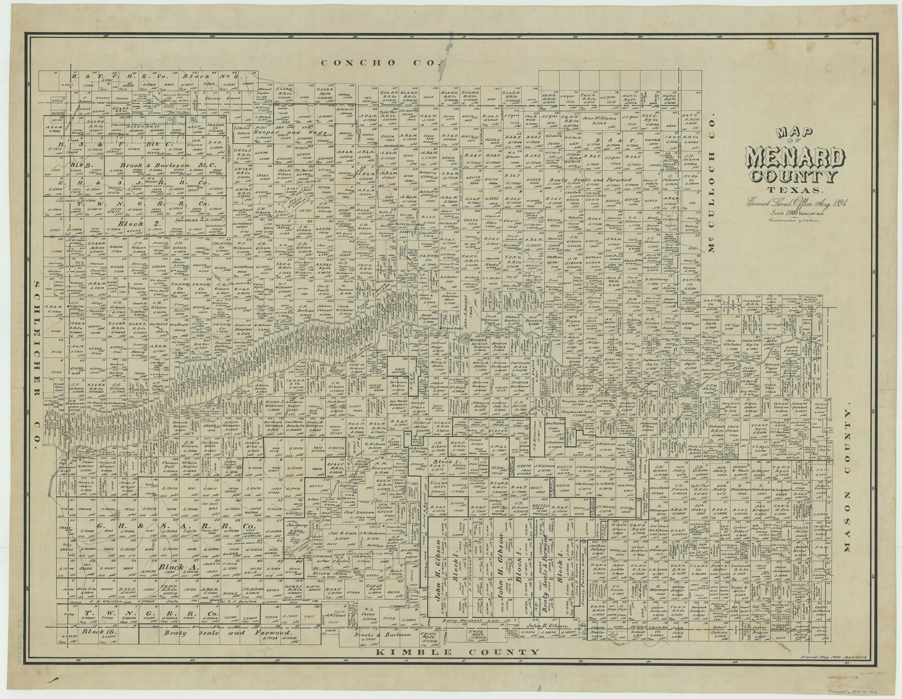
Map of Menard County Texas
-
Map/Doc
66927
-
Collection
General Map Collection
-
Object Dates
1894 (Creation Date)
-
People and Organizations
Texas General Land Office (Publisher)
W.H. Warren (Compiler)
W.H. Warren (Draftsman)
-
Counties
Menard
-
Subjects
County
-
Height x Width
33.0 x 42.5 inches
83.8 x 108.0 cm
-
Comments
Traced in May 1936 by A. C. Clark.
Part of: General Map Collection
Angelina County Rolled Sketch 2

Print $20.00
- Digital $50.00
Angelina County Rolled Sketch 2
1948
Size 21.9 x 20.1 inches
Map/Doc 77185
San Patricio County Sketch File 50

Print $8.00
- Digital $50.00
San Patricio County Sketch File 50
1873
Size 14.4 x 8.8 inches
Map/Doc 36371
Flight Mission No. CUG-1P, Frame 83, Kleberg County

Print $20.00
- Digital $50.00
Flight Mission No. CUG-1P, Frame 83, Kleberg County
1956
Size 18.5 x 22.2 inches
Map/Doc 86148
Texas Panhandle East Boundary Line

Print $20.00
- Digital $50.00
Texas Panhandle East Boundary Line
1898
Size 32.1 x 8.8 inches
Map/Doc 1700

Young County Boundary File 98a

Print $32.00
- Digital $50.00
Young County Boundary File 98a
Size 10.2 x 8.0 inches
Map/Doc 60211
Lampasas County Boundary File 4

Print $44.00
- Digital $50.00
Lampasas County Boundary File 4
Size 14.0 x 8.5 inches
Map/Doc 56110
Dominion of Canada and Newfoundland

Print $20.00
- Digital $50.00
Dominion of Canada and Newfoundland
1885
Size 12.2 x 9.0 inches
Map/Doc 93513
Clay County Sketch File 22

Print $6.00
- Digital $50.00
Clay County Sketch File 22
Size 12.8 x 8.3 inches
Map/Doc 18436
Angelina County

Print $40.00
- Digital $50.00
Angelina County
1945
Size 38.7 x 49.3 inches
Map/Doc 1770
Flight Mission No. BRA-6M, Frame 82, Jefferson County

Print $20.00
- Digital $50.00
Flight Mission No. BRA-6M, Frame 82, Jefferson County
1953
Size 18.5 x 22.3 inches
Map/Doc 85426
Denton County Sketch File 41

Print $6.00
- Digital $50.00
Denton County Sketch File 41
1883
Size 12.8 x 8.5 inches
Map/Doc 20789
You may also like
General Highway Map, La Salle County, Texas

Print $20.00
General Highway Map, La Salle County, Texas
1961
Size 18.2 x 24.8 inches
Map/Doc 79565
Jeff Davis County Rolled Sketch 22

Print $399.00
- Digital $50.00
Jeff Davis County Rolled Sketch 22
Size 17.2 x 15.8 inches
Map/Doc 6487
Plat Compiled by W. J. Williams, Plainview, Texas, and Sylvan Sanders, Lubbock, Texas Showing Position of Original and Re-Survey Corners in Lynn, Terry, Yoakum, Gaines and Dawson Counties, Texas

Print $40.00
- Digital $50.00
Plat Compiled by W. J. Williams, Plainview, Texas, and Sylvan Sanders, Lubbock, Texas Showing Position of Original and Re-Survey Corners in Lynn, Terry, Yoakum, Gaines and Dawson Counties, Texas
1946
Size 57.6 x 22.9 inches
Map/Doc 89689
Chambers County NRC Article 33.136 Sketch 8

Print $22.00
- Digital $50.00
Chambers County NRC Article 33.136 Sketch 8
2014
Size 17.7 x 24.0 inches
Map/Doc 94745
Jim Wells Co.

Print $20.00
- Digital $50.00
Jim Wells Co.
1966
Size 40.3 x 28.9 inches
Map/Doc 77331
Bandera County Working Sketch 53

Print $20.00
- Digital $50.00
Bandera County Working Sketch 53
1985
Size 34.0 x 36.0 inches
Map/Doc 67649
Hemphill County Rolled Sketch 17

Print $40.00
- Digital $50.00
Hemphill County Rolled Sketch 17
1965
Size 24.0 x 64.1 inches
Map/Doc 9157
Brazos River Conservation and Reclamation District Official Boundary Line Survey, Parmer County

Print $20.00
- Digital $50.00
Brazos River Conservation and Reclamation District Official Boundary Line Survey, Parmer County
Size 24.7 x 16.8 inches
Map/Doc 91656
Val Verde County Working Sketch 104

Print $20.00
- Digital $50.00
Val Verde County Working Sketch 104
1982
Size 26.4 x 19.0 inches
Map/Doc 72239
[Map of Sabine County]
![4009, [Map of Sabine County], General Map Collection](https://historictexasmaps.com/wmedia_w700/maps/4009.tif.jpg)
Print $20.00
- Digital $50.00
[Map of Sabine County]
1839
Size 23.9 x 18.9 inches
Map/Doc 4009
Harris County Sketch File 69

Print $12.00
- Digital $50.00
Harris County Sketch File 69
1938
Size 11.5 x 8.8 inches
Map/Doc 25512
[Worksheets related to the Wilson Strickland survey and vicinity]
![91283, [Worksheets related to the Wilson Strickland survey and vicinity], Twichell Survey Records](https://historictexasmaps.com/wmedia_w700/maps/91283-1.tif.jpg)
Print $20.00
- Digital $50.00
[Worksheets related to the Wilson Strickland survey and vicinity]
Size 9.9 x 29.7 inches
Map/Doc 91283