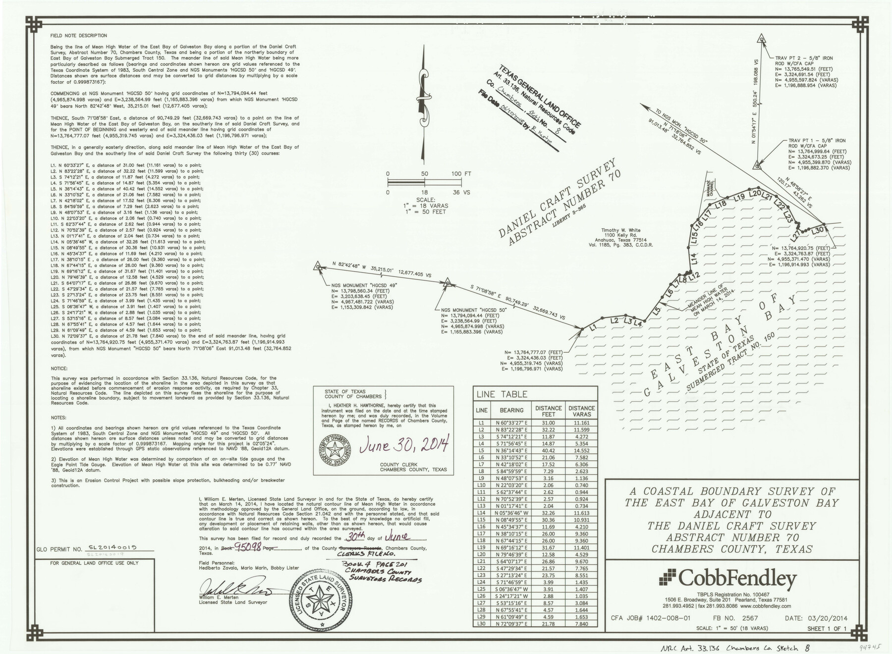
Chambers County NRC Article 33.136 Sketch 8
A coastal boundary survey of the East Bay of Galveston Bay adjacent to the Daniel Craft survey abstract number 70
-
Map/Doc
94745
-
Collection
General Map Collection
-
Object Dates
2014/3/20 (Creation Date)
2018/6/20 (File Date)
-
People and Organizations
William E. Merten (Surveyor/Engineer)
-
Counties
Chambers
-
Subjects
Surveying CBS
-
Height x Width
17.7 x 24.0 inches
45.0 x 61.0 cm
-
Medium
multi-page, multi-format
-
Scale
1" = 50' (18 varas)
-
Comments
Project: East Bay - Kelly Road Shoreline Protection Project No.: SL20140019 (GLO)
Part of: General Map Collection
Marion County Working Sketch 16

Print $20.00
- Digital $50.00
Marion County Working Sketch 16
1954
Size 22.6 x 25.4 inches
Map/Doc 70792
Carson County Boundary File 8a

Print $40.00
- Digital $50.00
Carson County Boundary File 8a
Size 12.5 x 34.7 inches
Map/Doc 51173
Sutton County Working Sketch 46

Print $40.00
- Digital $50.00
Sutton County Working Sketch 46
1953
Size 48.4 x 27.1 inches
Map/Doc 62389
Maps of Gulf Intracoastal Waterway, Texas - Sabine River to the Rio Grande and connecting waterways including ship channels

Print $20.00
- Digital $50.00
Maps of Gulf Intracoastal Waterway, Texas - Sabine River to the Rio Grande and connecting waterways including ship channels
1966
Size 14.5 x 22.3 inches
Map/Doc 61949
Live Oak County Sketch File 14

Print $4.00
- Digital $50.00
Live Oak County Sketch File 14
1882
Size 13.3 x 8.8 inches
Map/Doc 30278
Tyler County Sketch File 3

Print $10.00
- Digital $50.00
Tyler County Sketch File 3
1855
Size 8.5 x 8.0 inches
Map/Doc 38622
Right of Way and Track Map of The Missouri, Kansas & Texas Railway of Texas

Print $40.00
- Digital $50.00
Right of Way and Track Map of The Missouri, Kansas & Texas Railway of Texas
1918
Size 25.7 x 107.8 inches
Map/Doc 64532
Polk County Sketch File 22

Print $6.00
- Digital $50.00
Polk County Sketch File 22
1887
Size 8.9 x 7.5 inches
Map/Doc 34173
Hemphill County Rolled Sketch 2

Print $20.00
- Digital $50.00
Hemphill County Rolled Sketch 2
Size 26.4 x 29.8 inches
Map/Doc 6185
Dimmit County

Print $40.00
- Digital $50.00
Dimmit County
1976
Size 42.2 x 48.9 inches
Map/Doc 77265
Galveston County NRC Article 33.136 Sketch 74

Print $26.00
- Digital $50.00
Galveston County NRC Article 33.136 Sketch 74
2013
Size 24.0 x 36.0 inches
Map/Doc 95114
Plan of Three Sitios of Land Granted to Vicente Micheli

Print $2.00
- Digital $50.00
Plan of Three Sitios of Land Granted to Vicente Micheli
Size 9.2 x 8.6 inches
Map/Doc 18
You may also like
Gulf Coast of the United States, Key West to Rio Grande

Print $20.00
- Digital $50.00
Gulf Coast of the United States, Key West to Rio Grande
1863
Size 27.5 x 18.3 inches
Map/Doc 72664
Haskell County Boundary File 7

Print $40.00
- Digital $50.00
Haskell County Boundary File 7
Size 3.6 x 38.5 inches
Map/Doc 54584
Brewster County Rolled Sketch 60

Print $40.00
- Digital $50.00
Brewster County Rolled Sketch 60
Size 53.9 x 28.0 inches
Map/Doc 61784
The Republic County of Washington. January 15, 1842

Print $20.00
The Republic County of Washington. January 15, 1842
2020
Size 11.8 x 21.7 inches
Map/Doc 96306
Kinney County Working Sketch 21

Print $20.00
- Digital $50.00
Kinney County Working Sketch 21
1950
Size 23.7 x 18.5 inches
Map/Doc 70203
Map showing lands of D. Sullivan known as Santa Rosa Ranch, situated in Cameron and Hidalgo Counties, Texas

Print $20.00
- Digital $50.00
Map showing lands of D. Sullivan known as Santa Rosa Ranch, situated in Cameron and Hidalgo Counties, Texas
1905
Size 26.8 x 27.3 inches
Map/Doc 4451
Robertson County Working Sketch 11

Print $20.00
- Digital $50.00
Robertson County Working Sketch 11
1984
Size 20.2 x 21.4 inches
Map/Doc 63584
Map of Lands in King County, Texas owned and leased by the Louisville Land and Cattle Company

Print $20.00
- Digital $50.00
Map of Lands in King County, Texas owned and leased by the Louisville Land and Cattle Company
Size 32.1 x 25.9 inches
Map/Doc 5070
Maverick County Sketch File 25

Print $20.00
- Digital $50.00
Maverick County Sketch File 25
1914
Size 18.4 x 25.6 inches
Map/Doc 12055
Trinity County Working Sketch 16

Print $20.00
- Digital $50.00
Trinity County Working Sketch 16
1978
Size 31.7 x 41.2 inches
Map/Doc 69465
The Chief Justice County of Matagorda. Lands in Conflict with Brazoria County

Print $20.00
The Chief Justice County of Matagorda. Lands in Conflict with Brazoria County
2020
Size 19.7 x 21.7 inches
Map/Doc 96058
Henderson County Rolled Sketch 12

Print $20.00
- Digital $50.00
Henderson County Rolled Sketch 12
1980
Size 22.8 x 19.1 inches
Map/Doc 6204