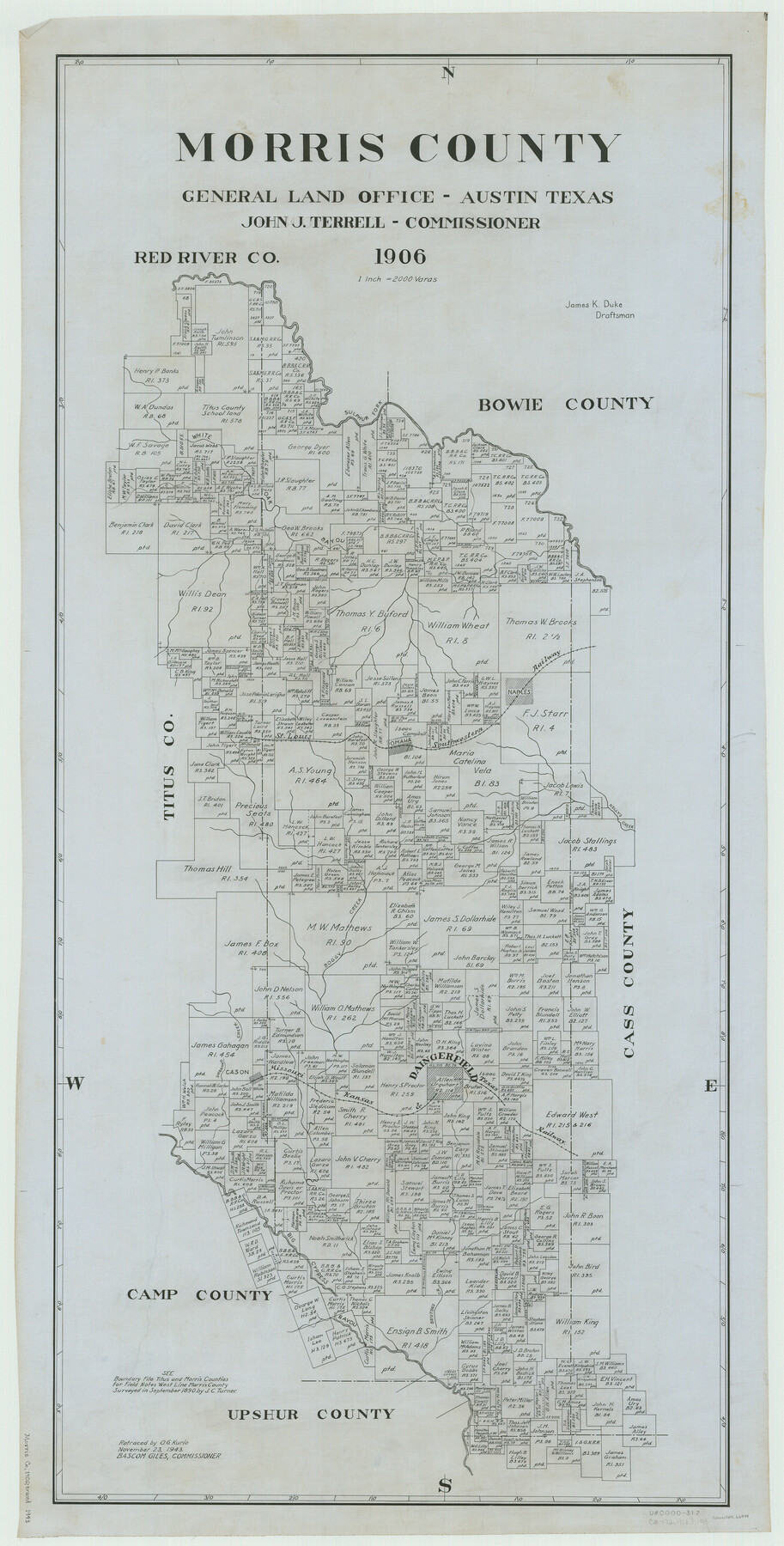
Morris County
-
Map/Doc
66944
-
Collection
General Map Collection
-
Object Dates
1906 (Creation Date)
-
People and Organizations
Texas General Land Office (Publisher)
James K. Duke (Draftsman)
John J. Terrell (GLO Commissioner)
James K. Duke (Compiler)
-
Counties
Morris
-
Subjects
County
-
Height x Width
44.1 x 22.4 inches
112.0 x 56.9 cm
-
Comments
Retraced November 23, 1943 by O. G. Kurio.
Part of: General Map Collection
Johnson County Working Sketch 17

Print $40.00
- Digital $50.00
Johnson County Working Sketch 17
1985
Size 48.3 x 44.4 inches
Map/Doc 66630
Callahan County

Print $20.00
- Digital $50.00
Callahan County
1879
Size 22.0 x 17.9 inches
Map/Doc 3362
Upton County Sketch File 27

Print $20.00
- Digital $50.00
Upton County Sketch File 27
1928
Size 42.9 x 22.6 inches
Map/Doc 10416
Lynn County Sketch File 1b

Print $8.00
- Digital $50.00
Lynn County Sketch File 1b
1940
Size 8.7 x 11.3 inches
Map/Doc 30515
Texas Aerial Photo-Illustrated Map

Texas Aerial Photo-Illustrated Map
Size 21.3 x 28.3 inches
Map/Doc 94397
Texas Gulf Coast Map from the Sabine River to the Rio Grande as subdivided for mineral development

Print $40.00
- Digital $50.00
Texas Gulf Coast Map from the Sabine River to the Rio Grande as subdivided for mineral development
1948
Size 60.9 x 36.7 inches
Map/Doc 2909
Nueces County Working Sketch 3

Print $20.00
- Digital $50.00
Nueces County Working Sketch 3
1972
Size 38.9 x 45.0 inches
Map/Doc 71305
Val Verde County Sketch File A1

Print $6.00
- Digital $50.00
Val Verde County Sketch File A1
1895
Size 14.4 x 9.2 inches
Map/Doc 39038
Cameron County

Print $20.00
- Digital $50.00
Cameron County
1913
Size 30.0 x 33.8 inches
Map/Doc 1793
Brewster County Rolled Sketch 101

Print $40.00
- Digital $50.00
Brewster County Rolled Sketch 101
1927
Size 74.2 x 42.3 inches
Map/Doc 9192
Crockett County Rolled Sketch FFF-11

Print $20.00
- Digital $50.00
Crockett County Rolled Sketch FFF-11
1937
Size 31.9 x 17.0 inches
Map/Doc 5637
Flight Mission No. BQY-4M, Frame 115, Harris County

Print $20.00
- Digital $50.00
Flight Mission No. BQY-4M, Frame 115, Harris County
1953
Size 18.6 x 22.5 inches
Map/Doc 85282
You may also like
Map of Matagorda Bay & Vicinity in Matagorda & Calhoun Counties Showing Subdivision for Mineral Development

Print $40.00
- Digital $50.00
Map of Matagorda Bay & Vicinity in Matagorda & Calhoun Counties Showing Subdivision for Mineral Development
1939
Size 46.1 x 55.5 inches
Map/Doc 2927
Young County Working Sketch 12

Print $20.00
- Digital $50.00
Young County Working Sketch 12
1921
Size 17.6 x 19.0 inches
Map/Doc 62035
A New Map of Texas, Oregon and California with the regions adjoining, compiled from the most recent authorities

Print $20.00
- Digital $50.00
A New Map of Texas, Oregon and California with the regions adjoining, compiled from the most recent authorities
Size 22.8 x 20.9 inches
Map/Doc 93990
Map of McClennan County

Print $20.00
- Digital $50.00
Map of McClennan County
1868
Size 22.8 x 25.4 inches
Map/Doc 3861
Liberty County Sketch File 38

Print $22.00
- Digital $50.00
Liberty County Sketch File 38
1899
Size 13.9 x 8.9 inches
Map/Doc 29983
Morris County Rolled Sketch 2A

Print $20.00
- Digital $50.00
Morris County Rolled Sketch 2A
Size 24.0 x 18.8 inches
Map/Doc 10275
Liberty County Working Sketch 67

Print $20.00
- Digital $50.00
Liberty County Working Sketch 67
1971
Size 35.3 x 44.5 inches
Map/Doc 70527
Jackson County

Print $40.00
- Digital $50.00
Jackson County
1920
Size 49.5 x 41.8 inches
Map/Doc 66878
Gillespie County Boundary File 7

Print $18.00
- Digital $50.00
Gillespie County Boundary File 7
Size 8.6 x 4.0 inches
Map/Doc 53771

El Paso County Working Sketch 19

Print $20.00
- Digital $50.00
El Paso County Working Sketch 19
1960
Size 20.8 x 20.8 inches
Map/Doc 69041
Map of Galveston, Harrisburg & San Antonio Railway in Pecos County

Print $40.00
- Digital $50.00
Map of Galveston, Harrisburg & San Antonio Railway in Pecos County
1888
Size 26.0 x 80.9 inches
Map/Doc 64399