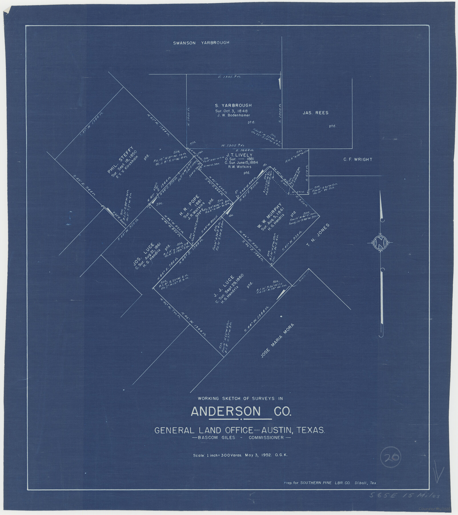
Anderson County Working Sketch 20
-
Map/Doc
67020
-
Collection
General Map Collection
-
Object Dates
5/3/1952 (Creation Date)
-
People and Organizations
Bascom Giles (GLO Commissioner)
Otto G. Kurio (Draftsman)
-
Counties
Anderson
-
Subjects
Surveying Working Sketch
-
Height x Width
23.1 x 20.6 inches
58.7 x 52.3 cm
-
Scale
1" = 300 varas
-
Comments
Surveys located about 15 miles South 65 degrees East of Palestine, Texas.
Part of: General Map Collection
Crockett County Working Sketch 69

Print $20.00
- Digital $50.00
Crockett County Working Sketch 69
1962
Size 34.8 x 45.5 inches
Map/Doc 68402
Hardin County Sketch File A

Print $20.00
- Digital $50.00
Hardin County Sketch File A
Size 19.3 x 33.4 inches
Map/Doc 11644
Flight Mission No. CGI-3N, Frame 121, Cameron County

Print $20.00
- Digital $50.00
Flight Mission No. CGI-3N, Frame 121, Cameron County
1954
Size 18.5 x 22.3 inches
Map/Doc 84594
Tarrant County Sketch File 21a

Print $4.00
- Digital $50.00
Tarrant County Sketch File 21a
1859
Size 8.0 x 8.1 inches
Map/Doc 37727
Matagorda County Working Sketch 10

Print $20.00
- Digital $50.00
Matagorda County Working Sketch 10
1958
Size 27.8 x 33.3 inches
Map/Doc 70868
Bexar County Working Sketch 21

Print $20.00
- Digital $50.00
Bexar County Working Sketch 21
1984
Size 21.3 x 28.8 inches
Map/Doc 67337
Gray County Working Sketch 2

Print $20.00
- Digital $50.00
Gray County Working Sketch 2
1957
Size 26.7 x 27.8 inches
Map/Doc 63233
Dickens County Working Sketch 8

Print $40.00
- Digital $50.00
Dickens County Working Sketch 8
1947
Size 68.5 x 43.7 inches
Map/Doc 68656
Jeff Davis County Sketch File 3

Print $22.00
- Digital $50.00
Jeff Davis County Sketch File 3
Size 12.3 x 8.6 inches
Map/Doc 27892
Upper Galveston Bay, Houston Ship Channel, Dollar Pt. to Atkinson I.

Print $40.00
- Digital $50.00
Upper Galveston Bay, Houston Ship Channel, Dollar Pt. to Atkinson I.
1972
Size 49.9 x 36.9 inches
Map/Doc 69895
Johnson County Working Sketch 21

Print $20.00
- Digital $50.00
Johnson County Working Sketch 21
1995
Size 18.1 x 29.6 inches
Map/Doc 66634
Flight Mission No. DIX-10P, Frame 79, Aransas County

Print $20.00
- Digital $50.00
Flight Mission No. DIX-10P, Frame 79, Aransas County
1956
Size 18.8 x 22.3 inches
Map/Doc 83940
You may also like
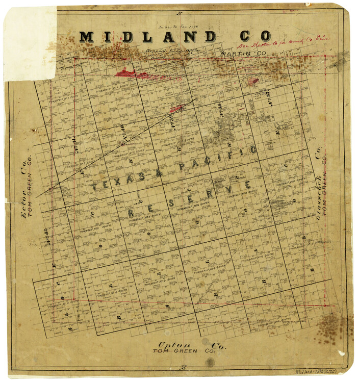
Midland County
Print $20.00
- Digital $50.00
Midland County
1896
Size 21.5 x 20.0 inches
Map/Doc 3877
Mills County Rolled Sketch 7

Print $20.00
- Digital $50.00
Mills County Rolled Sketch 7
2025
Size 23.7 x 29.8 inches
Map/Doc 97434
Map of Ellis County

Print $20.00
- Digital $50.00
Map of Ellis County
1857
Size 37.7 x 21.4 inches
Map/Doc 4536
Map of San Antonio Bay and Vicinity in Aransas and Calhoun Counties showing subdivision for mineral development

Print $40.00
- Digital $50.00
Map of San Antonio Bay and Vicinity in Aransas and Calhoun Counties showing subdivision for mineral development
1939
Size 40.4 x 62.8 inches
Map/Doc 2925
Pecos County Sketch File 76

Print $4.00
- Digital $50.00
Pecos County Sketch File 76
1943
Size 11.2 x 8.8 inches
Map/Doc 33907
Flight Mission No. BRA-6M, Frame 81, Jefferson County

Print $20.00
- Digital $50.00
Flight Mission No. BRA-6M, Frame 81, Jefferson County
1953
Size 18.6 x 22.6 inches
Map/Doc 85425
Leon County Rolled Sketch 22

Print $20.00
- Digital $50.00
Leon County Rolled Sketch 22
1983
Size 29.9 x 27.1 inches
Map/Doc 6608
Walker County Rolled Sketch 1

Print $20.00
- Digital $50.00
Walker County Rolled Sketch 1
1982
Size 36.3 x 23.6 inches
Map/Doc 8154
Colorado County Sketch File 20

Print $6.00
- Digital $50.00
Colorado County Sketch File 20
Size 6.0 x 7.6 inches
Map/Doc 18954
Presidio County Rolled Sketch 144

Print $20.00
- Digital $50.00
Presidio County Rolled Sketch 144
2010
Size 36.0 x 24.0 inches
Map/Doc 89603
The Republic County of Shelby. February 1, 1845

Print $20.00
The Republic County of Shelby. February 1, 1845
2020
Size 20.0 x 21.7 inches
Map/Doc 96287
Matagorda County Sketch File 7b

Print $4.00
- Digital $50.00
Matagorda County Sketch File 7b
1890
Size 14.2 x 8.8 inches
Map/Doc 30744