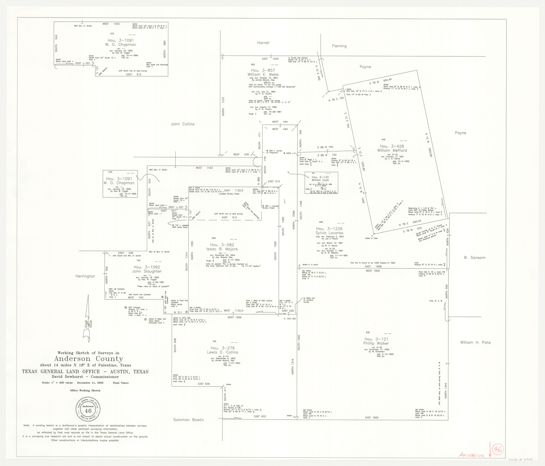
Anderson County Working Sketch 46
-
Map/Doc
67046
-
Collection
General Map Collection
-
Object Dates
12/11/2000 (Creation Date)
-
People and Organizations
Stasi Vance (Draftsman)
-
Counties
Anderson
-
Subjects
Surveying Working Sketch
-
Height x Width
29.2 x 34.2 inches
74.2 x 86.9 cm
-
Scale
1" = 200 varas
-
Comments
Surveys located about 14 miles North 18 degrees East of Palestine, Texas.
Part of: General Map Collection
Denton County Sketch File 17

Print $4.00
- Digital $50.00
Denton County Sketch File 17
1857
Size 12.7 x 8.4 inches
Map/Doc 20729
Sutton County Working Sketch 25

Print $40.00
- Digital $50.00
Sutton County Working Sketch 25
Size 69.4 x 37.1 inches
Map/Doc 62368
Hays County Working Sketch 13

Print $20.00
- Digital $50.00
Hays County Working Sketch 13
1952
Size 24.2 x 35.0 inches
Map/Doc 66087
Outer Continental Shelf Leasing Maps (Louisiana Offshore Operations)

Print $20.00
- Digital $50.00
Outer Continental Shelf Leasing Maps (Louisiana Offshore Operations)
1959
Size 18.3 x 14.5 inches
Map/Doc 76112
Nolan County Working Sketch 10

Print $40.00
- Digital $50.00
Nolan County Working Sketch 10
1971
Size 78.9 x 37.0 inches
Map/Doc 71301
United States Gulf Coast - from Galveston to the Rio Grande

Print $20.00
- Digital $50.00
United States Gulf Coast - from Galveston to the Rio Grande
1915
Size 26.6 x 18.3 inches
Map/Doc 72734
Blanco County Working Sketch 4

Print $20.00
- Digital $50.00
Blanco County Working Sketch 4
1885
Size 20.1 x 19.4 inches
Map/Doc 67363
Kent County Sketch File 8

Print $20.00
- Digital $50.00
Kent County Sketch File 8
Size 19.0 x 40.8 inches
Map/Doc 10515
Maverick County Rolled Sketch 21

Print $20.00
- Digital $50.00
Maverick County Rolled Sketch 21
Size 24.6 x 28.6 inches
Map/Doc 6713
Zavala County Working Sketch 25

Print $20.00
- Digital $50.00
Zavala County Working Sketch 25
1984
Size 37.7 x 30.0 inches
Map/Doc 62100
Brazoria County Sketch File 45

Print $20.00
- Digital $50.00
Brazoria County Sketch File 45
1980
Size 32.0 x 43.1 inches
Map/Doc 10326
Menard County Sketch File 28

Print $8.00
- Digital $50.00
Menard County Sketch File 28
1955
Size 11.0 x 8.6 inches
Map/Doc 31567
You may also like
Crockett County Sketch File 29

Print $8.00
- Digital $50.00
Crockett County Sketch File 29
1883
Size 12.5 x 8.1 inches
Map/Doc 19727
Flight Mission No. DAG-24K, Frame 139, Matagorda County

Print $20.00
- Digital $50.00
Flight Mission No. DAG-24K, Frame 139, Matagorda County
1953
Size 18.5 x 22.3 inches
Map/Doc 86557
Flight Mission No. CRC-4R, Frame 159, Chambers County

Print $20.00
- Digital $50.00
Flight Mission No. CRC-4R, Frame 159, Chambers County
1956
Size 18.6 x 22.2 inches
Map/Doc 84918
Flight Mission No. BQR-4K, Frame 67, Brazoria County

Print $20.00
- Digital $50.00
Flight Mission No. BQR-4K, Frame 67, Brazoria County
1952
Size 18.7 x 22.5 inches
Map/Doc 84000
Nolan County Working Sketch 6

Print $20.00
- Digital $50.00
Nolan County Working Sketch 6
1950
Size 27.2 x 26.0 inches
Map/Doc 71297
Surveys in Reeves and Culberson Counties, Texas and Pacific Railroad Company, Blocks 58, 59, 60, and 61

Print $20.00
- Digital $50.00
Surveys in Reeves and Culberson Counties, Texas and Pacific Railroad Company, Blocks 58, 59, 60, and 61
1937
Size 30.7 x 25.3 inches
Map/Doc 2250
Presidio County Sketch File 98

Print $44.00
- Digital $50.00
Presidio County Sketch File 98
1955
Size 11.3 x 8.8 inches
Map/Doc 34783
Liberty County Working Sketch 91b

Print $40.00
- Digital $50.00
Liberty County Working Sketch 91b
1919
Size 48.7 x 42.1 inches
Map/Doc 65458
Copy of Surveyor's Field Book, Morris Browning - In Blocks 7, 5 & 4, I&GNRRCo., Hutchinson and Carson Counties, Texas

Print $2.00
- Digital $50.00
Copy of Surveyor's Field Book, Morris Browning - In Blocks 7, 5 & 4, I&GNRRCo., Hutchinson and Carson Counties, Texas
1888
Size 7.0 x 8.9 inches
Map/Doc 62261
Working Sketch Cottle County

Print $20.00
- Digital $50.00
Working Sketch Cottle County
1916
Size 31.7 x 29.6 inches
Map/Doc 4434
Intracoastal Waterway in Texas - Corpus Christi to Point Isabel including Arroyo Colorado to Mo. Pac. R.R. Bridge Near Harlingen

Print $20.00
- Digital $50.00
Intracoastal Waterway in Texas - Corpus Christi to Point Isabel including Arroyo Colorado to Mo. Pac. R.R. Bridge Near Harlingen
1933
Size 28.4 x 41.2 inches
Map/Doc 61870
El Paso County Rolled Sketch Z53

Print $40.00
- Digital $50.00
El Paso County Rolled Sketch Z53
1915
Size 36.6 x 51.7 inches
Map/Doc 8869