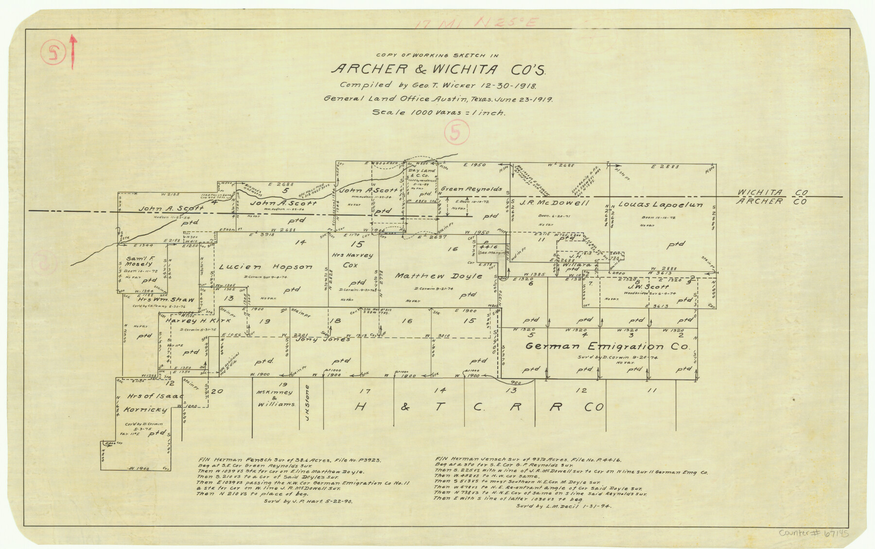
Archer County Working Sketch 5
-
Map/Doc
67145
-
Collection
General Map Collection
-
Object Dates
6/23/1919 (Creation Date)
-
People and Organizations
George T. Wicker (Compiler)
-
Counties
Archer Wichita
-
Subjects
Surveying Working Sketch
-
Height x Width
14.7 x 23.4 inches
37.3 x 59.4 cm
-
Scale
1" = 1000 varas
-
Comments
Surveys located about 17 miles North 25 degrees East of Archer City, Texas.
Part of: General Map Collection
Parker County Sketch File 32

Print $6.00
- Digital $50.00
Parker County Sketch File 32
Size 11.0 x 12.2 inches
Map/Doc 33574

Lee County Working Sketch 14

Print $20.00
- Digital $50.00
Lee County Working Sketch 14
1981
Size 17.9 x 11.4 inches
Map/Doc 70393
Runnels County Sketch File H

Print $4.00
Runnels County Sketch File H
1890
Size 14.3 x 8.8 inches
Map/Doc 35450
Ward County Working Sketch 39

Print $20.00
- Digital $50.00
Ward County Working Sketch 39
1969
Size 24.2 x 45.5 inches
Map/Doc 72345
Karnes County Sketch File 11

Print $4.00
- Digital $50.00
Karnes County Sketch File 11
1885
Size 10.5 x 8.1 inches
Map/Doc 28602
Pecos County Sketch File 114

Print $18.00
- Digital $50.00
Pecos County Sketch File 114
1912
Size 13.3 x 8.9 inches
Map/Doc 34074
Knox County Rolled Sketch 8

Print $20.00
- Digital $50.00
Knox County Rolled Sketch 8
Size 28.2 x 32.5 inches
Map/Doc 9406
Brewster County Sketch File 53

Print $94.00
- Digital $50.00
Brewster County Sketch File 53
1910
Size 13.3 x 8.9 inches
Map/Doc 16361
Carson County Boundary File 8

Print $40.00
- Digital $50.00
Carson County Boundary File 8
Size 7.8 x 35.0 inches
Map/Doc 51171
Crockett County Rolled Sketch 5

Print $40.00
- Digital $50.00
Crockett County Rolled Sketch 5
Size 25.0 x 63.0 inches
Map/Doc 8689
Dawson County Boundary File 3 (3)

Print $60.00
- Digital $50.00
Dawson County Boundary File 3 (3)
Size 11.0 x 35.8 inches
Map/Doc 52369
You may also like
Roberts County Working Sketch 31

Print $20.00
- Digital $50.00
Roberts County Working Sketch 31
1978
Size 26.6 x 22.4 inches
Map/Doc 63557
Franklin County Boundary File 1

Print $8.00
- Digital $50.00
Franklin County Boundary File 1
Size 12.9 x 8.1 inches
Map/Doc 53569
Eleven County Map

Print $40.00
- Digital $50.00
Eleven County Map
Size 39.2 x 57.5 inches
Map/Doc 89856
General Highway Map, Wood County, Texas

Print $20.00
General Highway Map, Wood County, Texas
1961
Size 18.1 x 24.8 inches
Map/Doc 79718
Webb County Sketch File C

Print $10.00
- Digital $50.00
Webb County Sketch File C
1915
Size 14.4 x 8.8 inches
Map/Doc 39668
Wilson County Sketch File 3b

Print $22.00
- Digital $50.00
Wilson County Sketch File 3b
Size 7.8 x 11.9 inches
Map/Doc 40402
Van Zandt County Rolled Sketch 8

Print $20.00
- Digital $50.00
Van Zandt County Rolled Sketch 8
1948
Size 38.4 x 23.9 inches
Map/Doc 8148
Plat of a survey of the North part of section 16, Block 362, Martha McBride, Presidio County, Texas

Print $4.00
- Digital $50.00
Plat of a survey of the North part of section 16, Block 362, Martha McBride, Presidio County, Texas
1989
Size 24.1 x 29.3 inches
Map/Doc 60520
Liberty County Working Sketch 90

Print $20.00
- Digital $50.00
Liberty County Working Sketch 90
2001
Size 23.1 x 43.1 inches
Map/Doc 70550
Terrell County

Print $20.00
- Digital $50.00
Terrell County
1905
Size 40.5 x 32.3 inches
Map/Doc 4075
Terry County School Land, Gaines County, Texas

Print $20.00
- Digital $50.00
Terry County School Land, Gaines County, Texas
Size 15.6 x 24.7 inches
Map/Doc 92678
