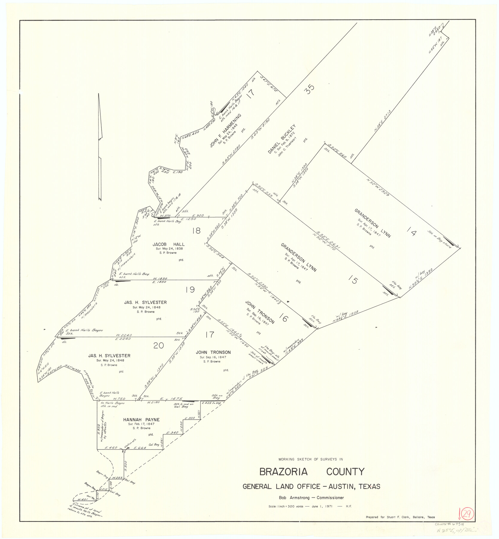
Brazoria County Working Sketch 29
-
Map/Doc
67514
-
Collection
General Map Collection
-
Object Dates
6/1/1971 (Creation Date)
-
People and Organizations
Bob Armstrong (GLO Commissioner)
Herman Forbes (Draftsman)
-
Counties
Brazoria
-
Subjects
Surveying Working Sketch
-
Height x Width
30.6 x 28.3 inches
77.7 x 71.9 cm
-
Scale
1" = 300 varas
-
Comments
Surveys located about 21 miles North 85 degrees East of Angleton, Texas.
Part of: General Map Collection
Eastland County Working Sketch 17

Print $20.00
- Digital $50.00
Eastland County Working Sketch 17
1919
Size 18.3 x 16.2 inches
Map/Doc 68798
Flight Mission No. DIX-5P, Frame 107, Aransas County

Print $20.00
- Digital $50.00
Flight Mission No. DIX-5P, Frame 107, Aransas County
1956
Size 17.6 x 17.8 inches
Map/Doc 83785
Andrews County

Print $40.00
- Digital $50.00
Andrews County
1951
Size 42.7 x 54.5 inches
Map/Doc 1769
Bell County Sketch File 27

Print $4.00
- Digital $50.00
Bell County Sketch File 27
1870
Size 8.9 x 9.4 inches
Map/Doc 14435
Culberson County Working Sketch 61

Print $40.00
- Digital $50.00
Culberson County Working Sketch 61
1974
Size 74.9 x 34.0 inches
Map/Doc 68515
Bell County Sketch File 15

Print $4.00
- Digital $50.00
Bell County Sketch File 15
1861
Size 6.4 x 8.0 inches
Map/Doc 14394
Pecos County Rolled Sketch 175

Print $20.00
- Digital $50.00
Pecos County Rolled Sketch 175
Size 21.2 x 26.2 inches
Map/Doc 7295
Flight Mission No. BRE-1P, Frame 118, Nueces County

Print $20.00
- Digital $50.00
Flight Mission No. BRE-1P, Frame 118, Nueces County
1956
Size 17.8 x 21.2 inches
Map/Doc 86684
Map of Tom Green County

Print $20.00
- Digital $50.00
Map of Tom Green County
1892
Size 44.1 x 47.5 inches
Map/Doc 78389
Midland County Sketch File 13

Print $4.00
- Digital $50.00
Midland County Sketch File 13
1940
Size 11.2 x 8.7 inches
Map/Doc 31576
Flight Mission No. BQR-9K, Frame 14, Brazoria County

Print $20.00
- Digital $50.00
Flight Mission No. BQR-9K, Frame 14, Brazoria County
1952
Size 18.7 x 22.3 inches
Map/Doc 84043
Nueces County Rolled Sketch 126

Print $20.00
- Digital $50.00
Nueces County Rolled Sketch 126
1998
Size 24.5 x 36.8 inches
Map/Doc 7161
You may also like
Flight Mission No. BRA-7M, Frame 34, Jefferson County

Print $20.00
- Digital $50.00
Flight Mission No. BRA-7M, Frame 34, Jefferson County
1953
Size 18.6 x 22.3 inches
Map/Doc 85485
Preliminary Chart of the Northwestern Part of the Gulf of Mexico

Print $20.00
Preliminary Chart of the Northwestern Part of the Gulf of Mexico
1855
Size 32.3 x 41.6 inches
Map/Doc 79334
Edwards County Sketch File 54

Print $20.00
- Digital $50.00
Edwards County Sketch File 54
Size 17.9 x 18.4 inches
Map/Doc 11447
[Notes and rough sketch of survey 6, Block 16 and survey 19 1/2, Block 19]
![93053, [Notes and rough sketch of survey 6, Block 16 and survey 19 1/2, Block 19], Twichell Survey Records](https://historictexasmaps.com/wmedia_w700/maps/93053-1.tif.jpg)
Print $20.00
- Digital $50.00
[Notes and rough sketch of survey 6, Block 16 and survey 19 1/2, Block 19]
Size 23.8 x 11.8 inches
Map/Doc 93053
Jim Wells County Rolled Sketch 1

Print $20.00
- Digital $50.00
Jim Wells County Rolled Sketch 1
1981
Size 43.2 x 32.4 inches
Map/Doc 9324
Stonewall County Rolled Sketch 27

Print $20.00
- Digital $50.00
Stonewall County Rolled Sketch 27
Size 31.0 x 44.2 inches
Map/Doc 9966
Angelina County Sketch File 3

Print $8.00
- Digital $50.00
Angelina County Sketch File 3
Size 7.7 x 7.6 inches
Map/Doc 12922
Burnet County Sketch File 20

Print $4.00
- Digital $50.00
Burnet County Sketch File 20
1862
Size 10.1 x 8.0 inches
Map/Doc 16712
Live Oak County Rolled Sketch 5

Print $20.00
- Digital $50.00
Live Oak County Rolled Sketch 5
1947
Size 33.6 x 32.2 inches
Map/Doc 9454
[H. & T. C. RR. Company Block 47, Sections 47, 48, 49, 50, 51, and 52]
![91221, [H. & T. C. RR. Company Block 47, Sections 47, 48, 49, 50, 51, and 52], Twichell Survey Records](https://historictexasmaps.com/wmedia_w700/maps/91221-1.tif.jpg)
Print $2.00
- Digital $50.00
[H. & T. C. RR. Company Block 47, Sections 47, 48, 49, 50, 51, and 52]
Size 8.5 x 11.2 inches
Map/Doc 91221
Childress County Sketch File 7a

Print $20.00
- Digital $50.00
Childress County Sketch File 7a
Size 14.9 x 17.7 inches
Map/Doc 11080
The Chief Justice County of Mina. Lands in Conflict with Colorado County

Print $20.00
The Chief Justice County of Mina. Lands in Conflict with Colorado County
2020
Size 15.8 x 21.7 inches
Map/Doc 96062