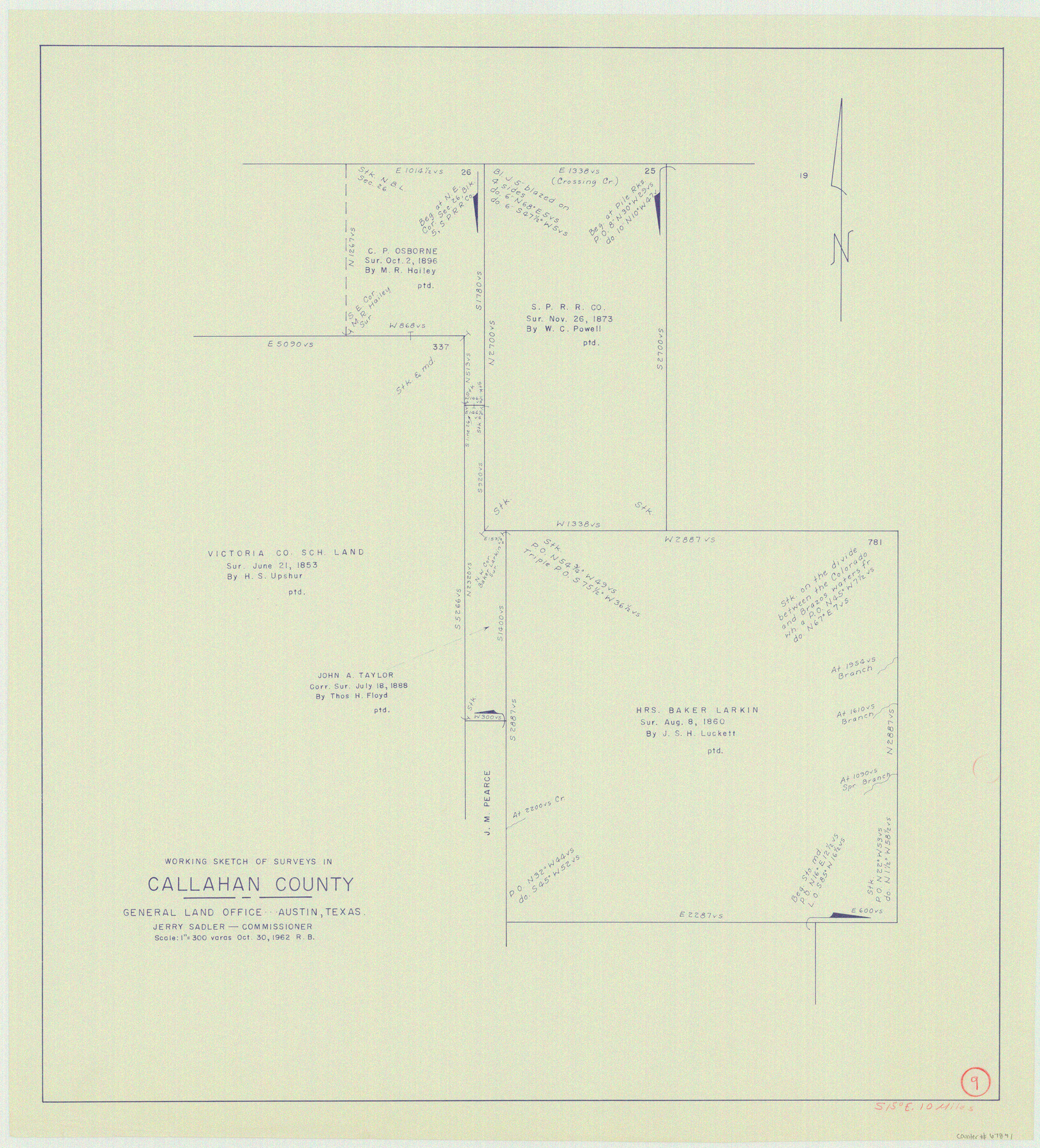
Callahan County Working Sketch 9
-
Map/Doc
67891
-
Collection
General Map Collection
-
Object Dates
10/30/1962 (Creation Date)
-
Counties
Callahan
-
Subjects
Surveying Working Sketch
-
Height x Width
28.3 x 25.6 inches
71.9 x 65.0 cm
-
Scale
1" = 300 varas
Part of: General Map Collection
Crockett County Sketch File 45

Print $14.00
- Digital $50.00
Crockett County Sketch File 45
Size 12.7 x 8.8 inches
Map/Doc 19772
Marion County Boundary File 2

Print $6.00
- Digital $50.00
Marion County Boundary File 2
Size 11.2 x 8.7 inches
Map/Doc 56818
Presidio County Working Sketch 13

Print $20.00
- Digital $50.00
Presidio County Working Sketch 13
1941
Size 25.7 x 41.5 inches
Map/Doc 71689
Galveston County Rolled Sketch 50

Print $20.00
- Digital $50.00
Galveston County Rolled Sketch 50
2011
Size 23.9 x 35.8 inches
Map/Doc 95179
Motley County Sketch File 7 (S)

Print $4.00
- Digital $50.00
Motley County Sketch File 7 (S)
Size 8.1 x 9.6 inches
Map/Doc 32149
[Surveys in DeLeon's Colony along the Garcitas River and Arenosa Creek, including the Victoria town tract]
![42, [Surveys in DeLeon's Colony along the Garcitas River and Arenosa Creek, including the Victoria town tract], General Map Collection](https://historictexasmaps.com/wmedia_w700/maps/42.tif.jpg)
Print $20.00
- Digital $50.00
[Surveys in DeLeon's Colony along the Garcitas River and Arenosa Creek, including the Victoria town tract]
1824
Size 22.1 x 17.6 inches
Map/Doc 42
Complete Report of John H. Clark's Survey of Texas-U. S. Boundary - 1859 through 1862, including maps

Print $323.00
Complete Report of John H. Clark's Survey of Texas-U. S. Boundary - 1859 through 1862, including maps
1882
Map/Doc 81685
Refugio County Working Sketch 5

Print $20.00
- Digital $50.00
Refugio County Working Sketch 5
1938
Size 36.5 x 42.2 inches
Map/Doc 63514
Red River County Sketch File 7

Print $6.00
- Digital $50.00
Red River County Sketch File 7
1855
Size 12.7 x 8.0 inches
Map/Doc 35109
San Jacinto County Sketch File 13a

Print $6.00
San Jacinto County Sketch File 13a
Size 8.2 x 13.0 inches
Map/Doc 35725
Duval County Boundary File 3

Print $14.00
- Digital $50.00
Duval County Boundary File 3
Size 8.6 x 3.9 inches
Map/Doc 52719
Maps of Gulf Intracoastal Waterway, Texas - Sabine River to the Rio Grande and connecting waterways including ship channels

Print $20.00
- Digital $50.00
Maps of Gulf Intracoastal Waterway, Texas - Sabine River to the Rio Grande and connecting waterways including ship channels
1966
Size 14.5 x 22.2 inches
Map/Doc 61974
You may also like
Hemphill County Working Sketch 20

Print $20.00
- Digital $50.00
Hemphill County Working Sketch 20
1972
Size 34.9 x 47.1 inches
Map/Doc 66115
Mills County Sketch File 23

Print $4.00
- Digital $50.00
Mills County Sketch File 23
Size 12.4 x 9.2 inches
Map/Doc 31672
Presidio County Rolled Sketch 105

Print $40.00
- Digital $50.00
Presidio County Rolled Sketch 105
Size 67.7 x 42.9 inches
Map/Doc 76180
Florida et Apalche

Print $20.00
- Digital $50.00
Florida et Apalche
1597
Size 11.2 x 14.4 inches
Map/Doc 94076
Hemphill County Working Sketch 36

Print $40.00
- Digital $50.00
Hemphill County Working Sketch 36
1978
Size 38.3 x 51.7 inches
Map/Doc 66131
Flight Mission No. BRA-3M, Frame 195, Jefferson County

Print $20.00
- Digital $50.00
Flight Mission No. BRA-3M, Frame 195, Jefferson County
1953
Size 18.6 x 22.3 inches
Map/Doc 85410
Jasper County Sketch File 3

Print $6.00
- Digital $50.00
Jasper County Sketch File 3
Size 10.1 x 15.2 inches
Map/Doc 27768
Kent County Boundary File 2

Print $4.00
- Digital $50.00
Kent County Boundary File 2
Size 10.1 x 8.2 inches
Map/Doc 55822
Terrell County Rolled Sketch 51B

Print $20.00
- Digital $50.00
Terrell County Rolled Sketch 51B
1957
Size 23.0 x 23.8 inches
Map/Doc 7969
Jim Wells County Working Sketch 12

Print $20.00
- Digital $50.00
Jim Wells County Working Sketch 12
1962
Size 19.2 x 15.6 inches
Map/Doc 66610
San Patricio County Rolled Sketch 34

Print $20.00
- Digital $50.00
San Patricio County Rolled Sketch 34
Size 25.8 x 26.2 inches
Map/Doc 7584
Henderson County Working Sketch 39

Print $20.00
- Digital $50.00
Henderson County Working Sketch 39
1982
Size 24.3 x 19.0 inches
Map/Doc 66172