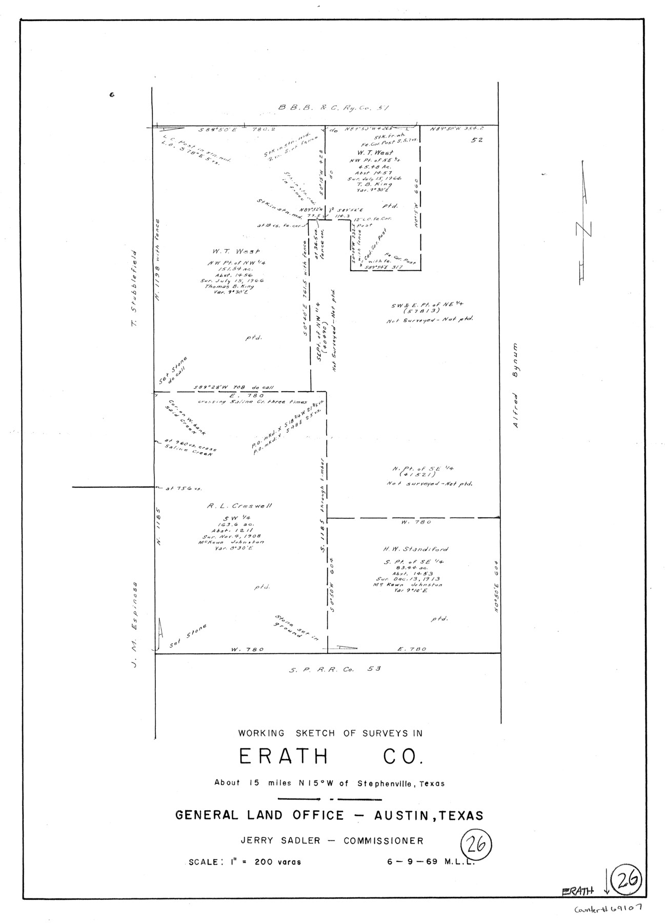
Erath County Working Sketch 26
-
Map/Doc
69107
-
Collection
General Map Collection
-
Object Dates
6/9/1969 (Creation Date)
-
People and Organizations
M. L. Liles (Draftsman)
-
Counties
Erath
-
Subjects
Surveying Working Sketch
-
Height x Width
20.8 x 15.0 inches
52.8 x 38.1 cm
-
Scale
1" = 200 varas
Part of: General Map Collection
Taylor County Working Sketch 14

Print $20.00
- Digital $50.00
Taylor County Working Sketch 14
1959
Size 26.8 x 21.4 inches
Map/Doc 69624
Flight Mission No. BRE-1P, Frame 125, Nueces County

Print $20.00
- Digital $50.00
Flight Mission No. BRE-1P, Frame 125, Nueces County
1956
Size 18.6 x 22.7 inches
Map/Doc 86691
Gaines County Rolled Sketch 20

Print $20.00
- Digital $50.00
Gaines County Rolled Sketch 20
1955
Size 30.1 x 37.2 inches
Map/Doc 5936
Harris County Sketch File 69b

Print $20.00
- Digital $50.00
Harris County Sketch File 69b
1938
Size 25.3 x 18.9 inches
Map/Doc 11664
Morris County Rolled Sketch 2A

Print $20.00
- Digital $50.00
Morris County Rolled Sketch 2A
Size 24.0 x 18.7 inches
Map/Doc 10287
Cottle County Rolled Sketch 7

Print $20.00
- Digital $50.00
Cottle County Rolled Sketch 7
Size 36.8 x 33.0 inches
Map/Doc 8675
Flight Mission No. DCL-4C, Frame 146, Kenedy County

Print $20.00
- Digital $50.00
Flight Mission No. DCL-4C, Frame 146, Kenedy County
1943
Size 18.6 x 22.3 inches
Map/Doc 85824
Crosby County Working Sketch 16

Print $40.00
- Digital $50.00
Crosby County Working Sketch 16
1979
Size 37.4 x 59.3 inches
Map/Doc 68450
Flight Mission No. CLL-3N, Frame 20, Willacy County

Print $20.00
- Digital $50.00
Flight Mission No. CLL-3N, Frame 20, Willacy County
1954
Size 18.5 x 22.1 inches
Map/Doc 87086
Leon County Rolled Sketch 14A

Print $200.00
- Digital $50.00
Leon County Rolled Sketch 14A
1975
Size 16.5 x 35.5 inches
Map/Doc 46535
Winkler County Working Sketch 17

Print $20.00
- Digital $50.00
Winkler County Working Sketch 17
1973
Size 36.5 x 36.7 inches
Map/Doc 72611
Coryell County Sketch File 4

Print $6.00
- Digital $50.00
Coryell County Sketch File 4
1854
Size 12.8 x 8.2 inches
Map/Doc 19342
You may also like
Hamilton County Working Sketch 28

Print $20.00
- Digital $50.00
Hamilton County Working Sketch 28
1976
Size 27.7 x 33.2 inches
Map/Doc 63366
Jackson County Rolled Sketch 15

Print $40.00
- Digital $50.00
Jackson County Rolled Sketch 15
1945
Size 53.7 x 30.3 inches
Map/Doc 9261
Navarro County Sketch File 17

Print $4.00
- Digital $50.00
Navarro County Sketch File 17
Size 12.8 x 8.4 inches
Map/Doc 32333
Map of Angelina County

Print $40.00
- Digital $50.00
Map of Angelina County
1899
Size 40.1 x 53.6 inches
Map/Doc 4868
Dawson County Sketch File C

Print $50.00
- Digital $50.00
Dawson County Sketch File C
1917
Size 14.3 x 8.8 inches
Map/Doc 20470
Texas, San Antonio Bay, Hynes Bay

Print $40.00
- Digital $50.00
Texas, San Antonio Bay, Hynes Bay
1934
Size 33.0 x 48.9 inches
Map/Doc 69998
Reagan County Sketch File 16

Print $8.00
- Digital $50.00
Reagan County Sketch File 16
1932
Size 11.1 x 7.7 inches
Map/Doc 35002
Andrews County Rolled Sketch 32

Print $20.00
- Digital $50.00
Andrews County Rolled Sketch 32
1950
Size 26.2 x 16.4 inches
Map/Doc 77176
Val Verde County Working Sketch 47

Print $20.00
- Digital $50.00
Val Verde County Working Sketch 47
1946
Size 41.4 x 42.6 inches
Map/Doc 72182
Montague County Sketch File 28

Print $4.00
- Digital $50.00
Montague County Sketch File 28
1963
Size 18.7 x 22.6 inches
Map/Doc 12110
[Right of Way & Track Map, The Texas & Pacific Ry. Co. Main Line]
![64668, [Right of Way & Track Map, The Texas & Pacific Ry. Co. Main Line], General Map Collection](https://historictexasmaps.com/wmedia_w700/maps/64668.tif.jpg)
Print $20.00
- Digital $50.00
[Right of Way & Track Map, The Texas & Pacific Ry. Co. Main Line]
Size 11.0 x 18.4 inches
Map/Doc 64668
