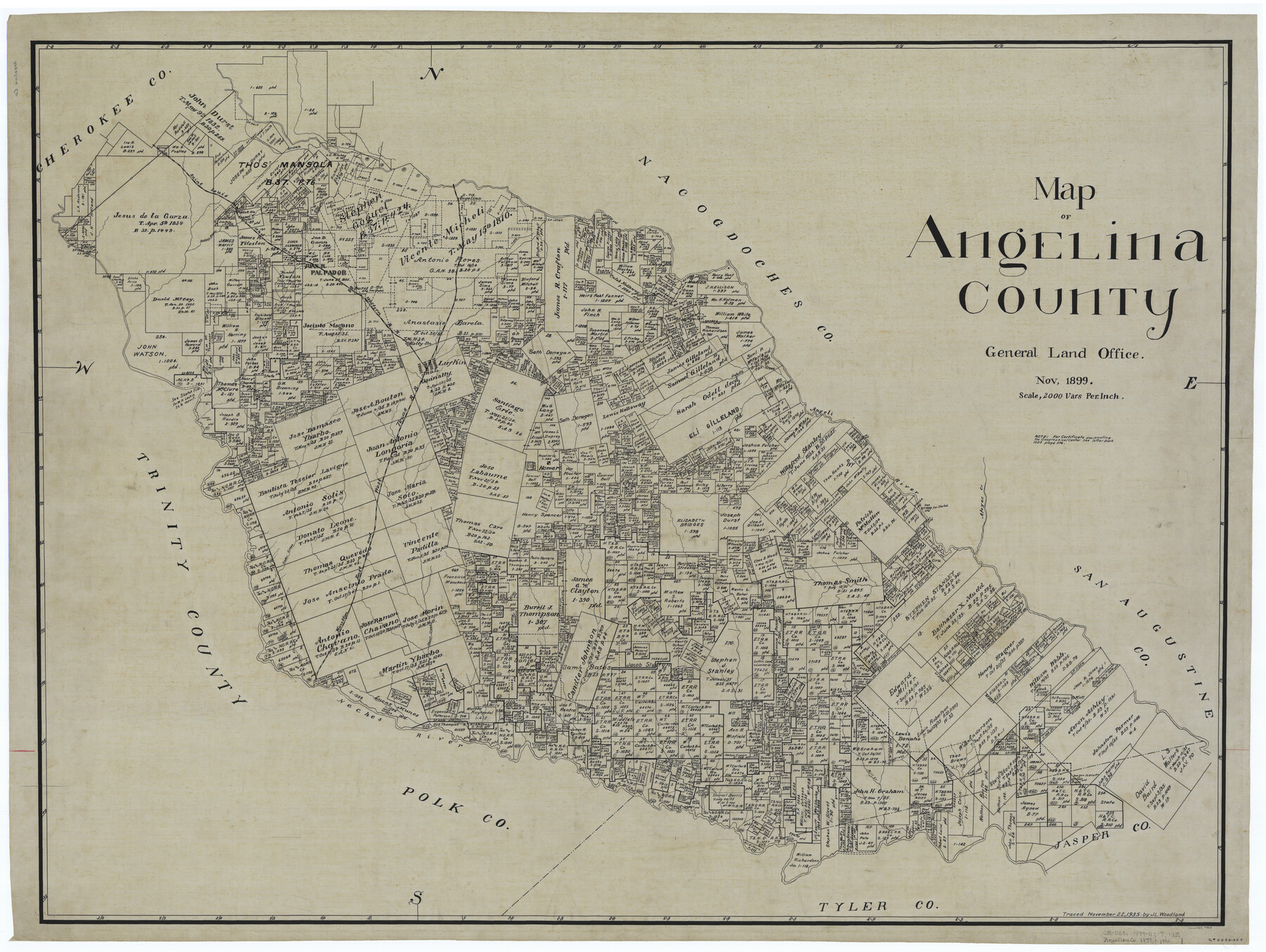
Map of Angelina County
-
Map/Doc
4868
-
Collection
General Map Collection
-
Object Dates
1899 (Creation Date)
-
People and Organizations
Texas General Land Office (Publisher)
-
Counties
Angelina
-
Subjects
County
-
Height x Width
40.1 x 53.6 inches
101.9 x 136.1 cm
-
Comments
Traced November 22, 1935 by J. L. Woodland.
Part of: General Map Collection
Map of the New England or Eastern States engraved to illustrate Mitchell's new intermediate geography

Print $20.00
- Digital $50.00
Map of the New England or Eastern States engraved to illustrate Mitchell's new intermediate geography
1885
Size 12.2 x 9.0 inches
Map/Doc 93515
Lubbock County Sketch File 15

Print $6.00
- Digital $50.00
Lubbock County Sketch File 15
1902
Size 11.2 x 8.8 inches
Map/Doc 30440
Jefferson County Rolled Sketch 57

Print $20.00
- Digital $50.00
Jefferson County Rolled Sketch 57
1883
Size 25.9 x 18.6 inches
Map/Doc 6407
Fractional Township No. 8 South Range No. 6 West of the Indian Meridian, Indian Territory

Print $20.00
- Digital $50.00
Fractional Township No. 8 South Range No. 6 West of the Indian Meridian, Indian Territory
1898
Size 19.3 x 24.4 inches
Map/Doc 75187
Montgomery County Working Sketch 12

Print $20.00
- Digital $50.00
Montgomery County Working Sketch 12
1933
Size 32.5 x 31.9 inches
Map/Doc 71119
Medina County Boundary File 3

Print $8.00
- Digital $50.00
Medina County Boundary File 3
Size 11.2 x 8.7 inches
Map/Doc 57031
Cottle County Working Sketch 16

Print $20.00
- Digital $50.00
Cottle County Working Sketch 16
1975
Size 24.5 x 21.6 inches
Map/Doc 68326
Terrell County Working Sketch 35a

Print $20.00
- Digital $50.00
Terrell County Working Sketch 35a
1948
Size 26.4 x 45.1 inches
Map/Doc 62128
Flight Mission No. DAG-17K, Frame 143, Matagorda County

Print $20.00
- Digital $50.00
Flight Mission No. DAG-17K, Frame 143, Matagorda County
1952
Size 16.4 x 16.4 inches
Map/Doc 86360
Flight Mission No. BQR-22K, Frame 45, Brazoria County

Print $20.00
- Digital $50.00
Flight Mission No. BQR-22K, Frame 45, Brazoria County
1953
Size 18.7 x 22.4 inches
Map/Doc 84129
Jeff Davis County Rolled Sketch 13

Print $73.00
- Digital $50.00
Jeff Davis County Rolled Sketch 13
1921
Size 20.0 x 23.3 inches
Map/Doc 6366
Webb County Working Sketch 95

Print $20.00
- Digital $50.00
Webb County Working Sketch 95
1991
Size 16.6 x 42.2 inches
Map/Doc 72462
You may also like
Jefferson County Working Sketch 43

Print $20.00
- Digital $50.00
Jefferson County Working Sketch 43
1960
Size 42.7 x 31.1 inches
Map/Doc 73591
Hutchinson County Sketch File 44

Print $82.00
- Digital $50.00
Hutchinson County Sketch File 44
1989
Size 11.2 x 9.0 inches
Map/Doc 27311
Falls County Sketch File 29

Print $40.00
- Digital $50.00
Falls County Sketch File 29
Size 19.9 x 23.5 inches
Map/Doc 75994
Sketch in Gray County

Print $20.00
- Digital $50.00
Sketch in Gray County
1910
Size 15.1 x 18.5 inches
Map/Doc 90741
Flight Mission No. BQY-14M, Frame 183, Harris County

Print $20.00
- Digital $50.00
Flight Mission No. BQY-14M, Frame 183, Harris County
1953
Size 18.5 x 22.4 inches
Map/Doc 85299
Jack County Sketch File 19

Print $4.00
- Digital $50.00
Jack County Sketch File 19
1878
Size 10.4 x 8.3 inches
Map/Doc 27559
Brewster County Sketch File 19

Print $6.00
- Digital $50.00
Brewster County Sketch File 19
1943
Size 13.2 x 8.8 inches
Map/Doc 15817
Map of the Trinity Artesian Reservoirs of the Black and Grand Prairies of Texas including the Eastern and Western Cross Timbers

Print $20.00
- Digital $50.00
Map of the Trinity Artesian Reservoirs of the Black and Grand Prairies of Texas including the Eastern and Western Cross Timbers
1900
Size 32.7 x 31.9 inches
Map/Doc 75920
Nueces County Sketch File 44

Print $8.00
- Digital $50.00
Nueces County Sketch File 44
1953
Size 11.2 x 8.7 inches
Map/Doc 32637
Navarro County

Print $40.00
- Digital $50.00
Navarro County
1924
Size 41.5 x 47.9 inches
Map/Doc 73249
Controlled Mosaic by Jack Amman Photogrammetric Engineers, Inc - Sheet 39

Print $20.00
- Digital $50.00
Controlled Mosaic by Jack Amman Photogrammetric Engineers, Inc - Sheet 39
1954
Size 20.0 x 24.0 inches
Map/Doc 83494
Map of the State of Texas

Print $40.00
- Digital $50.00
Map of the State of Texas
1879
Size 102.7 x 57.6 inches
Map/Doc 93383