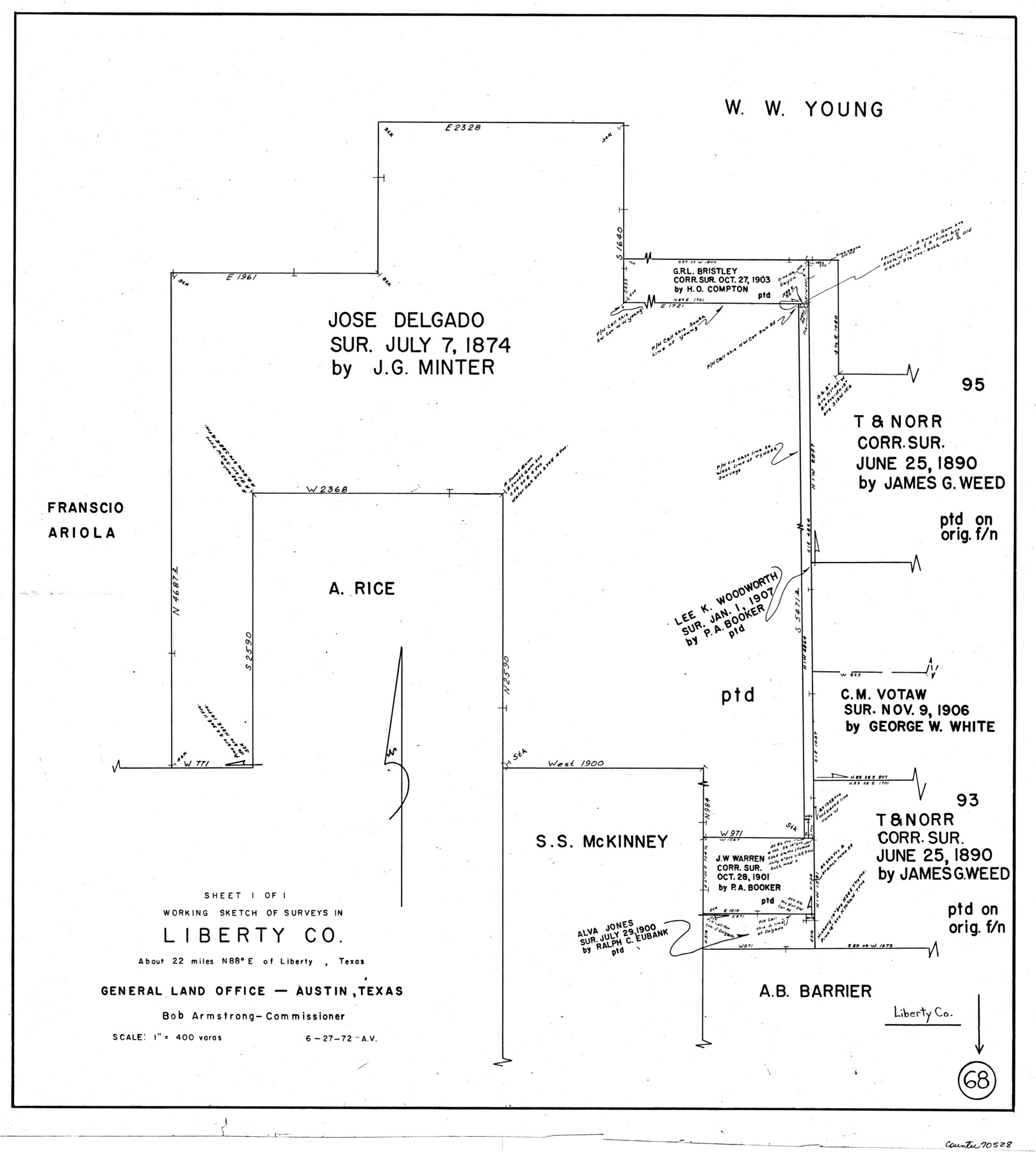
Liberty County Working Sketch 68
-
Map/Doc
70528
-
Collection
General Map Collection
-
Object Dates
6/27/1972 (Creation Date)
-
Counties
Liberty
-
Subjects
Surveying Working Sketch
-
Height x Width
27.4 x 24.6 inches
69.6 x 62.5 cm
-
Scale
1" = 400 varas
Part of: General Map Collection
Flight Mission No. CRE-1R, Frame 121, Jackson County

Print $20.00
- Digital $50.00
Flight Mission No. CRE-1R, Frame 121, Jackson County
1956
Size 16.2 x 16.0 inches
Map/Doc 85332
Nueces County Sketch File 13

Print $20.00
- Digital $50.00
Nueces County Sketch File 13
1940
Size 18.3 x 18.7 inches
Map/Doc 42178
Flight Mission No. CGI-1N, Frame 180, Cameron County

Print $20.00
- Digital $50.00
Flight Mission No. CGI-1N, Frame 180, Cameron County
1955
Size 18.5 x 22.2 inches
Map/Doc 84515
Castro County Sketch File 2

Print $20.00
- Digital $50.00
Castro County Sketch File 2
Size 24.7 x 17.7 inches
Map/Doc 11057
Williamson County Sketch File 4

Print $26.00
- Digital $50.00
Williamson County Sketch File 4
1849
Size 15.9 x 10.4 inches
Map/Doc 40304
Atascosa County Working Sketch 16

Print $20.00
- Digital $50.00
Atascosa County Working Sketch 16
1943
Size 16.3 x 20.2 inches
Map/Doc 67212
Gillespie County Working Sketch 10

Print $20.00
- Digital $50.00
Gillespie County Working Sketch 10
1994
Size 45.0 x 35.1 inches
Map/Doc 63173
Throckmorton County

Print $20.00
- Digital $50.00
Throckmorton County
1943
Size 40.1 x 32.8 inches
Map/Doc 77435
Hardin County Working Sketch 36

Print $40.00
- Digital $50.00
Hardin County Working Sketch 36
1981
Size 76.8 x 37.5 inches
Map/Doc 63434
Map of Brazos County, Texas

Print $40.00
- Digital $50.00
Map of Brazos County, Texas
1926
Size 89.6 x 55.1 inches
Map/Doc 93648
Hutchinson County Rolled Sketch 40

Print $20.00
- Digital $50.00
Hutchinson County Rolled Sketch 40
1981
Size 25.7 x 37.4 inches
Map/Doc 6297
Map of the Middle States and part of the Southern engraved to illustrate Mitchell's school and family geography

Print $20.00
- Digital $50.00
Map of the Middle States and part of the Southern engraved to illustrate Mitchell's school and family geography
1839
Size 17.8 x 11.8 inches
Map/Doc 93496
You may also like
Harris County Working Sketch 125

Print $20.00
- Digital $50.00
Harris County Working Sketch 125
1995
Size 42.0 x 34.0 inches
Map/Doc 66017
Galveston County Sketch File 4

Print $6.00
- Digital $50.00
Galveston County Sketch File 4
1850
Size 12.8 x 8.0 inches
Map/Doc 23355
Live Oak County Sketch File 11a

Print $4.00
- Digital $50.00
Live Oak County Sketch File 11a
1876
Size 12.7 x 8.3 inches
Map/Doc 30265
Angelina County Working Sketch 42

Print $20.00
- Digital $50.00
Angelina County Working Sketch 42
1960
Size 22.4 x 18.2 inches
Map/Doc 67125
[Sketch for Mineral Application 1112 - Colorado River, H. E. Chambers]
![65637, [Sketch for Mineral Application 1112 - Colorado River, H. E. Chambers], General Map Collection](https://historictexasmaps.com/wmedia_w700/maps/65637.tif.jpg)
Print $20.00
- Digital $50.00
[Sketch for Mineral Application 1112 - Colorado River, H. E. Chambers]
1918
Size 5.5 x 8.5 inches
Map/Doc 65637
Flight Mission No. DCL-7C, Frame 134, Kenedy County

Print $20.00
- Digital $50.00
Flight Mission No. DCL-7C, Frame 134, Kenedy County
1943
Size 18.5 x 22.3 inches
Map/Doc 86091
Upton County Rolled Sketch 57

Print $20.00
- Digital $50.00
Upton County Rolled Sketch 57
Size 30.1 x 41.8 inches
Map/Doc 8090
Flight Mission No. DAG-21K, Frame 91, Matagorda County

Print $20.00
- Digital $50.00
Flight Mission No. DAG-21K, Frame 91, Matagorda County
1952
Size 18.5 x 22.4 inches
Map/Doc 86420
Newton County Sketch File 19

Print $20.00
- Digital $50.00
Newton County Sketch File 19
Size 22.8 x 9.4 inches
Map/Doc 42158
Presidio County Working Sketch 126

Print $20.00
- Digital $50.00
Presidio County Working Sketch 126
1987
Size 36.9 x 46.5 inches
Map/Doc 71804
Flight Mission No. DAG-26K, Frame 83, Matagorda County

Print $20.00
- Digital $50.00
Flight Mission No. DAG-26K, Frame 83, Matagorda County
1953
Size 18.6 x 19.6 inches
Map/Doc 86588
Rusk County Working Sketch 23

Print $20.00
- Digital $50.00
Rusk County Working Sketch 23
1949
Size 23.9 x 26.5 inches
Map/Doc 63659