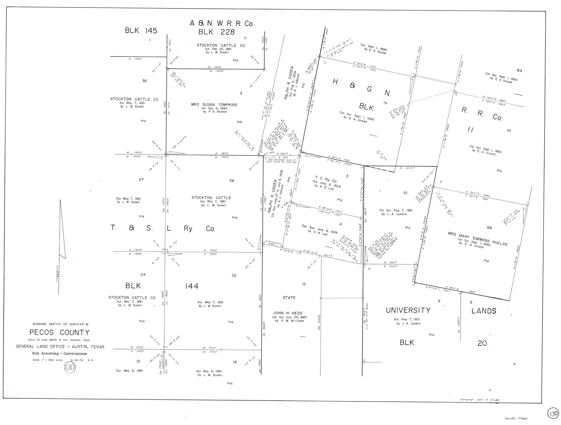
Pecos County Working Sketch 130
-
Map/Doc
71604
-
Collection
General Map Collection
-
Object Dates
4/20/1976 (Creation Date)
-
People and Organizations
Beverly Robison (Draftsman)
-
Counties
Pecos
-
Subjects
Surveying Working Sketch
-
Height x Width
27.6 x 36.5 inches
70.1 x 92.7 cm
-
Scale
1" = 300 varas
Part of: General Map Collection
Coke County Working Sketch 21

Print $20.00
- Digital $50.00
Coke County Working Sketch 21
1949
Size 22.9 x 29.4 inches
Map/Doc 68058
Culberson County Working Sketch 69

Print $40.00
- Digital $50.00
Culberson County Working Sketch 69
1975
Size 49.4 x 32.2 inches
Map/Doc 68523
Brazoria County Sketch File 9

Print $6.00
- Digital $50.00
Brazoria County Sketch File 9
Size 14.0 x 9.0 inches
Map/Doc 14936
Cottle County Sketch File 6

Print $20.00
- Digital $50.00
Cottle County Sketch File 6
1883
Size 20.3 x 29.8 inches
Map/Doc 11190
Flight Mission No. BRE-2P, Frame 67, Nueces County

Print $20.00
- Digital $50.00
Flight Mission No. BRE-2P, Frame 67, Nueces County
1956
Size 18.5 x 22.3 inches
Map/Doc 86762
Val Verde County

Print $20.00
- Digital $50.00
Val Verde County
1944
Size 42.3 x 37.8 inches
Map/Doc 73311
Liberty County Sketch File 6

Print $6.00
- Digital $50.00
Liberty County Sketch File 6
1856
Size 12.1 x 7.7 inches
Map/Doc 29893

Richardson's New Map of the State of Texas prepared for the Texas Almanac

Print $20.00
- Digital $50.00
Richardson's New Map of the State of Texas prepared for the Texas Almanac
1873
Size 19.8 x 27.1 inches
Map/Doc 96873
Right of Way & Track Map San Antonio & Aransas Pass Railway Co.

Print $40.00
- Digital $50.00
Right of Way & Track Map San Antonio & Aransas Pass Railway Co.
1919
Size 25.1 x 56.7 inches
Map/Doc 64026
Richardson's New Map of the State of Texas, corrected for the Texas Almanac to 1872

Print $20.00
- Digital $50.00
Richardson's New Map of the State of Texas, corrected for the Texas Almanac to 1872
1872
Size 18.4 x 26.4 inches
Map/Doc 93647
DeWitt County Sketch File 3

Print $20.00
- Digital $50.00
DeWitt County Sketch File 3
1871
Size 23.2 x 33.1 inches
Map/Doc 11312
You may also like
[Sketch of part of G. & M. Block 5, G. & M. Block 4, Block M19 and Block 21W]
![93081, [Sketch of part of G. & M. Block 5, G. & M. Block 4, Block M19 and Block 21W], Twichell Survey Records](https://historictexasmaps.com/wmedia_w700/maps/93081-1.tif.jpg)
Print $20.00
- Digital $50.00
[Sketch of part of G. & M. Block 5, G. & M. Block 4, Block M19 and Block 21W]
Size 21.7 x 16.6 inches
Map/Doc 93081
Hopkins County Sketch File 20

Print $4.00
- Digital $50.00
Hopkins County Sketch File 20
1871
Size 12.8 x 8.3 inches
Map/Doc 26725
Hemphill County

Print $20.00
- Digital $50.00
Hemphill County
1878
Size 19.1 x 16.9 inches
Map/Doc 3661
Gulf Intracoastal Waterway - Aransas Bay to Corpus Christi Bay - Modified Route Main Channel

Print $20.00
- Digital $50.00
Gulf Intracoastal Waterway - Aransas Bay to Corpus Christi Bay - Modified Route Main Channel
Size 30.9 x 41.9 inches
Map/Doc 61904
Working Sketch in Crockett County

Print $20.00
- Digital $50.00
Working Sketch in Crockett County
1923
Size 23.2 x 29.6 inches
Map/Doc 90315
Liberty County Working Sketch 39

Print $20.00
- Digital $50.00
Liberty County Working Sketch 39
1951
Size 26.2 x 24.1 inches
Map/Doc 70498
Coast Chart No. 209 - Aransas Pass, Aransas and Copano Bays, Texas

Print $20.00
- Digital $50.00
Coast Chart No. 209 - Aransas Pass, Aransas and Copano Bays, Texas
1889
Size 31.2 x 24.9 inches
Map/Doc 73429
Callahan County

Print $20.00
- Digital $50.00
Callahan County
1918
Size 45.3 x 41.0 inches
Map/Doc 66743
Lavaca County Rolled Sketch 7

Print $20.00
- Digital $50.00
Lavaca County Rolled Sketch 7
Size 37.4 x 32.7 inches
Map/Doc 10291
Hardin County Sketch File 52

Print $6.00
- Digital $50.00
Hardin County Sketch File 52
Size 11.5 x 8.9 inches
Map/Doc 25210
Anderson County

Print $20.00
- Digital $50.00
Anderson County
1871
Size 18.3 x 20.8 inches
Map/Doc 776
Mitchell County Boundary File 1b

Print $36.00
- Digital $50.00
Mitchell County Boundary File 1b
Size 13.8 x 8.7 inches
Map/Doc 57351