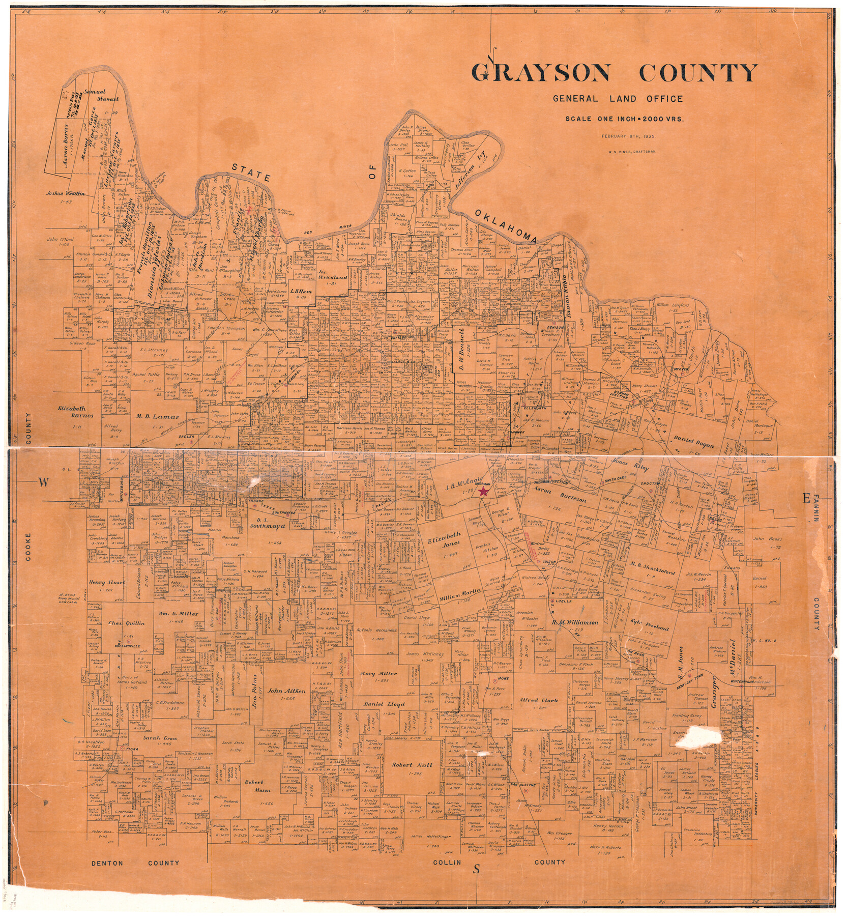
Grayson County
-
Map/Doc
73162
-
Collection
General Map Collection
-
Object Dates
1935/2/8 (Creation Date)
-
People and Organizations
Texas General Land Office (Publisher)
W.S. Vines (Draftsman)
-
Counties
Grayson
-
Subjects
County
-
Height x Width
42.4 x 39.5 inches
107.7 x 100.3 cm
-
Comments
Hand lettered.
-
Features
Luella
Choctaw Bayou
Shannon Creek
Sherman Junction
Sherman
T&P
Southmayde
Thorne
Whitesboro
SL&SW
Culton
Smith Oaks
Red River
Whitewright
Kentucky Town
Tom Bean
Howe
Collinsville
Tioga
Van Alstyne
Mineral Creek
Bonham Junction
MK&T
MO&G
Shawnee Creek
Denison
Pottsboro
Big Mineral Creek
Little Sandy Creek
Brushy Creek
Big Sandy Creek
Sadler
Deavers
Little Mineral Creek
Schenck
H&TC
D&P
Ellsworth
Bonham Junction
Iron Ore Creek
Grover
Mill Creek
Choctaw
Bells
Part of: General Map Collection
Castro County Working Sketch 4

Print $20.00
- Digital $50.00
Castro County Working Sketch 4
1920
Size 17.0 x 16.2 inches
Map/Doc 67899
Jeff Davis County Working Sketch 49

Print $20.00
- Digital $50.00
Jeff Davis County Working Sketch 49
2008
Size 38.0 x 35.7 inches
Map/Doc 88816
Real County Rolled Sketch 18

Print $20.00
- Digital $50.00
Real County Rolled Sketch 18
Size 22.2 x 28.2 inches
Map/Doc 7461
Trace of a copy of the map captured at the battle of Resaca de la Palma

Print $20.00
- Digital $50.00
Trace of a copy of the map captured at the battle of Resaca de la Palma
Size 18.3 x 27.3 inches
Map/Doc 73054
Nueces County Sketch File 22

Print $20.00
- Digital $50.00
Nueces County Sketch File 22
Size 19.0 x 31.0 inches
Map/Doc 42181
Aransas County Rolled Sketch 1

Print $40.00
- Digital $50.00
Aransas County Rolled Sketch 1
1930
Size 11.5 x 49.5 inches
Map/Doc 10685
Deaf Smith County Working Sketch 6

Print $20.00
- Digital $50.00
Deaf Smith County Working Sketch 6
2019
Size 36.5 x 24.5 inches
Map/Doc 95408
[Sketch for Mineral Application 26501 - Sabine River, T. A. Oldhausen]
![2837, [Sketch for Mineral Application 26501 - Sabine River, T. A. Oldhausen], General Map Collection](https://historictexasmaps.com/wmedia_w700/maps/2837.tif.jpg)
Print $20.00
- Digital $50.00
[Sketch for Mineral Application 26501 - Sabine River, T. A. Oldhausen]
1931
Size 24.1 x 36.0 inches
Map/Doc 2837
Hardin County Working Sketch 5

Print $20.00
- Digital $50.00
Hardin County Working Sketch 5
1921
Size 31.0 x 22.0 inches
Map/Doc 63403
Presidio County Working Sketch 114

Print $40.00
- Digital $50.00
Presidio County Working Sketch 114
1981
Size 63.9 x 37.9 inches
Map/Doc 71791
Flight Mission No. BRA-16M, Frame 183, Jefferson County

Print $20.00
- Digital $50.00
Flight Mission No. BRA-16M, Frame 183, Jefferson County
1953
Size 18.7 x 22.5 inches
Map/Doc 85781
Van Zandt County Sketch File 15a

Print $4.00
- Digital $50.00
Van Zandt County Sketch File 15a
1858
Size 6.7 x 8.1 inches
Map/Doc 39406
You may also like
Southern Pacific Lines in Texas and Louisiana (G. H. & S. A. Ry.) Circuit Plan of Automatic Block Signals, Automatic Train Control and Flatonia Interlocking Plant No. 3

Print $40.00
- Digital $50.00
Southern Pacific Lines in Texas and Louisiana (G. H. & S. A. Ry.) Circuit Plan of Automatic Block Signals, Automatic Train Control and Flatonia Interlocking Plant No. 3
1927
Size 43.5 x 215.5 inches
Map/Doc 90044

Presidio County Rolled Sketch 104

Print $20.00
- Digital $50.00
Presidio County Rolled Sketch 104
1948
Size 26.1 x 40.0 inches
Map/Doc 7386

Freestone County Rolled Sketch 13B

Print $20.00
- Digital $50.00
Freestone County Rolled Sketch 13B
1989
Size 25.2 x 20.5 inches
Map/Doc 5915
[Blocks Z3, S, H1 and 1 and vicinity]
![93120, [Blocks Z3, S, H1 and 1 and vicinity], Twichell Survey Records](https://historictexasmaps.com/wmedia_w700/maps/93120-1.tif.jpg)
Print $40.00
- Digital $50.00
[Blocks Z3, S, H1 and 1 and vicinity]
Size 54.0 x 32.2 inches
Map/Doc 93120
Aransas County Working Sketch 2

Print $3.00
- Digital $50.00
Aransas County Working Sketch 2
1926
Size 16.3 x 9.7 inches
Map/Doc 67169
Flight Mission No. DQN-2K, Frame 45, Calhoun County

Print $20.00
- Digital $50.00
Flight Mission No. DQN-2K, Frame 45, Calhoun County
1953
Size 18.4 x 22.2 inches
Map/Doc 84250
Colorado County Rolled Sketch 4

Print $20.00
- Digital $50.00
Colorado County Rolled Sketch 4
1944
Size 31.9 x 21.9 inches
Map/Doc 8643
Hopkins County Working Sketch 3

Print $20.00
- Digital $50.00
Hopkins County Working Sketch 3
1955
Size 24.2 x 20.0 inches
Map/Doc 66228
Lampasas County Rolled Sketch 2

Print $20.00
- Digital $50.00
Lampasas County Rolled Sketch 2
Size 21.0 x 39.2 inches
Map/Doc 6565
Denton County Rolled Sketch 5

Print $20.00
- Digital $50.00
Denton County Rolled Sketch 5
1973
Size 31.9 x 36.6 inches
Map/Doc 8776