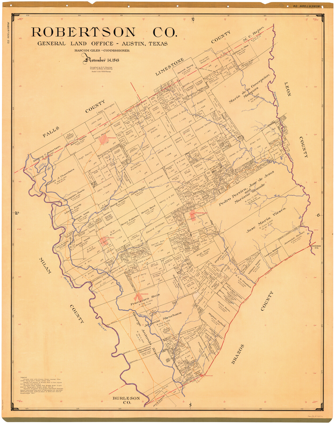
Robertson Co.
-
Map/Doc
73276
-
Collection
General Map Collection
-
Object Dates
1945/11/14 (Creation Date)
-
People and Organizations
Texas General Land Office (Publisher)
Eltea Armstrong (Draftsman)
Bascom Giles (GLO Commissioner)
G.C. Morriss (Compiler)
-
Counties
Robertson
-
Subjects
County
-
Height x Width
48.5 x 39.3 inches
123.2 x 99.8 cm
-
Comments
Hand lettered.
Note on reverse side: "Compilation completed November 14, 1945. Inking completed January 28, 1946. Tracing completed February 21, 1946. Placed in official use February 25, 1946. Replaced [on sticks] by copy June 6, 1946." -
Features
Spring Creek
Nacogdoches Road
Copperas Creek
Brazos River
I&GN
Little Brazos River
San Antonio Road
Pin Oak Creek
Hearne
Cedar Creek
Peach Creek
Benchley
Campbells Creek
San Antonio and Nacogdoches Road
Reiss Creek
Sand Lake
Davis Lake
Grassy Lake
Bear Creek
Steele Creek
Navasota River
Red Oak Creek
Bremond
Alligator Creek
T&NO
Walnut Creek
Duck Creek
Mineral Creek
Birch Creek
South Walnut Creek
Franklin
Camp Creek
Calvert
Muddy Creek
Part of: General Map Collection
Uvalde County Working Sketch 35

Print $20.00
- Digital $50.00
Uvalde County Working Sketch 35
1964
Size 30.3 x 30.2 inches
Map/Doc 72105
Pecos County Sketch File 31

Print $20.00
- Digital $50.00
Pecos County Sketch File 31
1931
Size 14.3 x 32.4 inches
Map/Doc 12173
Hunt County Rolled Sketch 5

Print $20.00
- Digital $50.00
Hunt County Rolled Sketch 5
1956
Size 28.6 x 24.3 inches
Map/Doc 6268
Floyd County Sketch File 10

Print $12.00
- Digital $50.00
Floyd County Sketch File 10
1912
Size 11.6 x 8.9 inches
Map/Doc 22701
Engineer's Office, Department of the Gulf Map No. 59, Texas prepared by order of Maj. Gen. N. P. Banks under direction of Capt. P. C. Hains, U. S. Engr. & Chief Engr., Dept. of the Gulf

Print $20.00
- Digital $50.00
Engineer's Office, Department of the Gulf Map No. 59, Texas prepared by order of Maj. Gen. N. P. Banks under direction of Capt. P. C. Hains, U. S. Engr. & Chief Engr., Dept. of the Gulf
1865
Size 18.2 x 27.5 inches
Map/Doc 72718
Val Verde County Working Sketch 98

Print $20.00
- Digital $50.00
Val Verde County Working Sketch 98
1980
Size 26.5 x 31.8 inches
Map/Doc 72233
McLennan County Sketch File 18

Print $8.00
- Digital $50.00
McLennan County Sketch File 18
1880
Size 12.8 x 8.3 inches
Map/Doc 31280
Gaines County Rolled Sketch 32

Print $20.00
- Digital $50.00
Gaines County Rolled Sketch 32
1902
Size 20.5 x 29.9 inches
Map/Doc 5945
Flight Mission No. CRC-2R, Frame 181, Chambers County

Print $20.00
- Digital $50.00
Flight Mission No. CRC-2R, Frame 181, Chambers County
1956
Size 18.7 x 22.4 inches
Map/Doc 84759
Kinney County Sketch File E1

Print $20.00
- Digital $50.00
Kinney County Sketch File E1
1885
Size 29.8 x 31.9 inches
Map/Doc 10619
Hill County Sketch File 14

Print $4.00
- Digital $50.00
Hill County Sketch File 14
Size 3.8 x 4.3 inches
Map/Doc 26480
Archer County Working Sketch 5

Print $20.00
- Digital $50.00
Archer County Working Sketch 5
1919
Size 14.7 x 23.4 inches
Map/Doc 67145
You may also like
Map of the Missouri Pacific and St. Louis, Iron Mountain and Southern Railways and Connections

Print $20.00
- Digital $50.00
Map of the Missouri Pacific and St. Louis, Iron Mountain and Southern Railways and Connections
1898
Size 17.7 x 32.1 inches
Map/Doc 95791
Chambers County Sketch File A

Print $20.00
- Digital $50.00
Chambers County Sketch File A
1900
Size 21.3 x 21.5 inches
Map/Doc 11071
La Salle County Sketch File 48

Print $6.00
- Digital $50.00
La Salle County Sketch File 48
1942
Size 11.2 x 8.8 inches
Map/Doc 29617
Carson County Boundary File 10

Print $2.00
- Digital $50.00
Carson County Boundary File 10
Size 11.5 x 7.2 inches
Map/Doc 51185
[East half of Crockett County]
![92997, [East half of Crockett County], Twichell Survey Records](https://historictexasmaps.com/wmedia_w700/maps/92997-1.tif.jpg)
Print $20.00
- Digital $50.00
[East half of Crockett County]
Size 15.2 x 21.9 inches
Map/Doc 92997
Brazoria County Rolled Sketch 38

Print $20.00
- Digital $50.00
Brazoria County Rolled Sketch 38
1949
Size 44.6 x 39.5 inches
Map/Doc 8460
Erath County Working Sketch 12

Print $20.00
- Digital $50.00
Erath County Working Sketch 12
1964
Size 22.3 x 23.1 inches
Map/Doc 69093

Cochran County

Print $20.00
- Digital $50.00
Cochran County
1913
Size 28.2 x 20.8 inches
Map/Doc 4911
Guadalupe County Sketch File 11

Print $4.00
- Digital $50.00
Guadalupe County Sketch File 11
Size 8.0 x 12.8 inches
Map/Doc 24681
Fannin County Working Sketch Graphic Index

Print $20.00
- Digital $50.00
Fannin County Working Sketch Graphic Index
1946
Size 41.3 x 36.2 inches
Map/Doc 76540
Crane County Sketch File 20

Print $4.00
- Digital $50.00
Crane County Sketch File 20
1928
Size 14.4 x 9.0 inches
Map/Doc 19588