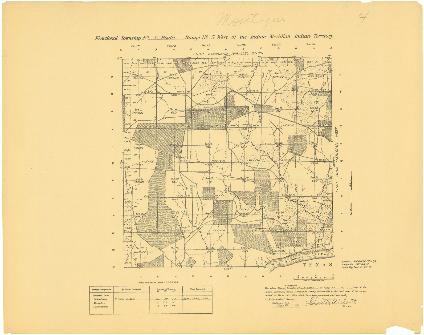
Fractional Township No. 6 South Range No. 5 West of the Indian Meridian, Indian Territory
-
Map/Doc
75190
-
Collection
General Map Collection
-
Object Dates
1898/4/18 (Creation Date)
-
Subjects
Texas Boundaries
-
Height x Width
19.3 x 24.3 inches
49.0 x 61.7 cm
Part of: General Map Collection
Midland County Working Sketch 8

Print $20.00
- Digital $50.00
Midland County Working Sketch 8
1950
Size 41.4 x 32.9 inches
Map/Doc 70988
[Maps of surveys in Reeves & Culberson Cos]
![61145, [Maps of surveys in Reeves & Culberson Cos], General Map Collection](https://historictexasmaps.com/wmedia_w700/maps/61145.tif.jpg)
Print $20.00
- Digital $50.00
[Maps of surveys in Reeves & Culberson Cos]
1937
Size 30.8 x 25.0 inches
Map/Doc 61145

Val Verde County Working Sketch 51

Print $20.00
- Digital $50.00
Val Verde County Working Sketch 51
1952
Size 24.5 x 30.0 inches
Map/Doc 72186
Dickens County

Print $20.00
- Digital $50.00
Dickens County
1915
Size 42.2 x 39.0 inches
Map/Doc 66805
Cherokee County Sketch File 30

Print $17.00
- Digital $50.00
Cherokee County Sketch File 30
1934
Size 10.3 x 9.4 inches
Map/Doc 18176
Crockett County Sketch File 64

Print $20.00
- Digital $50.00
Crockett County Sketch File 64
1927
Size 17.0 x 21.3 inches
Map/Doc 11229
Fort Bend County State Real Property Sketch 10

Print $40.00
- Digital $50.00
Fort Bend County State Real Property Sketch 10
1985
Size 43.4 x 34.7 inches
Map/Doc 61684
Map of Texas from the most recent authorities

Map of Texas from the most recent authorities
1845
Size 11.2 x 17.2 inches
Map/Doc 4333
Duval County Rolled Sketch 20

Print $20.00
- Digital $50.00
Duval County Rolled Sketch 20
Size 33.2 x 42.0 inches
Map/Doc 8811
Walker County Working Sketch 11

Print $20.00
- Digital $50.00
Walker County Working Sketch 11
1935
Size 28.2 x 38.8 inches
Map/Doc 72291
Aransas County Sketch File 38

Print $244.00
- Digital $50.00
Aransas County Sketch File 38
1996
Size 11.1 x 8.7 inches
Map/Doc 13465
You may also like
Childress County Sketch File 15a

Print $4.00
- Digital $50.00
Childress County Sketch File 15a
Size 8.6 x 11.7 inches
Map/Doc 18303
Swisher County Rolled Sketch 4

Print $20.00
- Digital $50.00
Swisher County Rolled Sketch 4
1904
Size 16.2 x 18.0 inches
Map/Doc 7905
[Map of Texas]
![96624, [Map of Texas], Cobb Digital Map Collection](https://historictexasmaps.com/wmedia_w700/maps/96624.tif.jpg)
Print $20.00
- Digital $50.00
[Map of Texas]
1869
Size 9.9 x 8.8 inches
Map/Doc 96624
Castro County Sketch File 4e

Print $4.00
- Digital $50.00
Castro County Sketch File 4e
Size 13.6 x 8.9 inches
Map/Doc 17473
Webb County Working Sketch 94

Print $20.00
- Digital $50.00
Webb County Working Sketch 94
1989
Size 23.1 x 25.6 inches
Map/Doc 72461
Baylor County Sketch File 23a

Print $10.00
- Digital $50.00
Baylor County Sketch File 23a
1927
Size 14.3 x 8.9 inches
Map/Doc 14204
Harris County Sketch File 61

Print $20.00
- Digital $50.00
Harris County Sketch File 61
1927
Size 19.4 x 16.7 inches
Map/Doc 11659
Starr County Sketch File 7

Print $20.00
- Digital $50.00
Starr County Sketch File 7
Size 25.4 x 20.8 inches
Map/Doc 12326
[Surveys near Keechi Creek and the Trinity River]
![47, [Surveys near Keechi Creek and the Trinity River], General Map Collection](https://historictexasmaps.com/wmedia_w700/maps/47.tif.jpg)
Print $2.00
- Digital $50.00
[Surveys near Keechi Creek and the Trinity River]
1841
Size 8.6 x 8.2 inches
Map/Doc 47
Hood County Rolled Sketch 7

Print $20.00
- Digital $50.00
Hood County Rolled Sketch 7
2009
Size 19.1 x 24.5 inches
Map/Doc 89062
[Map of Val Verde County]
![4110, [Map of Val Verde County], General Map Collection](https://historictexasmaps.com/wmedia_w700/maps/4110-1.tif.jpg)
Print $20.00
- Digital $50.00
[Map of Val Verde County]
1931
Size 36.4 x 24.1 inches
Map/Doc 4110
Flight Mission No. BRA-7M, Frame 35, Jefferson County

Print $20.00
- Digital $50.00
Flight Mission No. BRA-7M, Frame 35, Jefferson County
1953
Size 18.7 x 22.4 inches
Map/Doc 85486