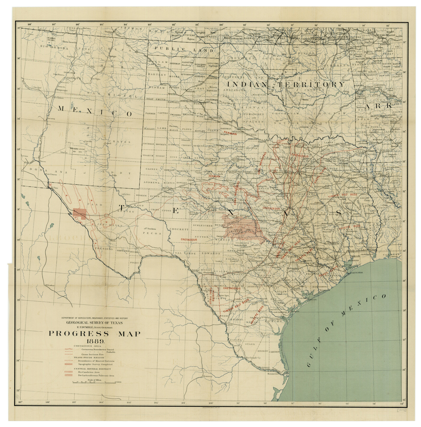
Progress Map
-
Map/Doc
76283
-
Collection
Texas State Library and Archives
-
Object Dates
1889 (Creation Date)
-
People and Organizations
Geological Survey of Texas (Publisher)
E.T. Dumble (Compiler)
-
Subjects
State of Texas
-
Height x Width
24.8 x 24.4 inches
63.0 x 62.0 cm
-
Comments
Prints available courtesy of the Texas State Library and Archives.
More info can be found here: TSLAC Map 03150
Part of: Texas State Library and Archives
New Commercial Map of Texas

Print $20.00
New Commercial Map of Texas
1900
Size 28.1 x 34.0 inches
Map/Doc 76199
General Highway Map. Detail of Cities and Towns in Bastrop County, Texas [Bastrop, Smithville, Elgin, etc.]
![79362, General Highway Map. Detail of Cities and Towns in Bastrop County, Texas [Bastrop, Smithville, Elgin, etc.], Texas State Library and Archives](https://historictexasmaps.com/wmedia_w700/maps/79362.tif.jpg)
Print $20.00
General Highway Map. Detail of Cities and Towns in Bastrop County, Texas [Bastrop, Smithville, Elgin, etc.]
1961
Size 18.3 x 25.0 inches
Map/Doc 79362
General Highway Map, Jasper County, Newton County, Texas

Print $20.00
General Highway Map, Jasper County, Newton County, Texas
1940
Size 18.6 x 25.0 inches
Map/Doc 79141
General Highway Map, Medina County, Texas

Print $20.00
General Highway Map, Medina County, Texas
1940
Size 18.3 x 24.5 inches
Map/Doc 79194
General Highway Map, Panola County, Texas

Print $20.00
General Highway Map, Panola County, Texas
1961
Size 18.1 x 24.5 inches
Map/Doc 79624
Mappa Geographica Regionem Mexicanam et Floridam, Terrasque adjacentes, ut et Anteriores Americae Insulas, Curfus itidem et Reditus Navigantuim verfus flumen Missisipi et alias Colonias ob oculos ponens, cura et fumptibus

Print $20.00
Mappa Geographica Regionem Mexicanam et Floridam, Terrasque adjacentes, ut et Anteriores Americae Insulas, Curfus itidem et Reditus Navigantuim verfus flumen Missisipi et alias Colonias ob oculos ponens, cura et fumptibus
1725
Size 20.0 x 24.0 inches
Map/Doc 76196
General Highway Map, Rains County, Texas

Print $20.00
General Highway Map, Rains County, Texas
1961
Size 18.1 x 24.4 inches
Map/Doc 79634
General Highway Map, El Paso County, Texas

Print $20.00
General Highway Map, El Paso County, Texas
1940
Size 18.4 x 24.7 inches
Map/Doc 79084
General Highway Map, Gray County, Texas

Print $20.00
General Highway Map, Gray County, Texas
1940
Size 25.0 x 18.4 inches
Map/Doc 79103
General Highway Map, Jim Hogg County, Texas

Print $20.00
General Highway Map, Jim Hogg County, Texas
1940
Size 24.8 x 18.5 inches
Map/Doc 79146
Map of Texas and the Countries Adjacent compiled in the Bureau of the Corps of Topographical Engineers from the Best Authorities

Print $20.00
Map of Texas and the Countries Adjacent compiled in the Bureau of the Corps of Topographical Engineers from the Best Authorities
1844
Size 24.5 x 35.8 inches
Map/Doc 76197
General Highway Map, Llano County, Texas

Print $20.00
General Highway Map, Llano County, Texas
1940
Size 18.4 x 24.9 inches
Map/Doc 79178
You may also like
Montgomery County Rolled Sketch 45

Print $20.00
- Digital $50.00
Montgomery County Rolled Sketch 45
2006
Size 20.5 x 31.3 inches
Map/Doc 85242
Hardin County Sketch File 32a

Print $11.00
- Digital $50.00
Hardin County Sketch File 32a
Size 8.4 x 9.8 inches
Map/Doc 25167
El Paso County Sketch File 35 (6)

Print $20.00
- Digital $50.00
El Paso County Sketch File 35 (6)
1886
Size 20.3 x 36.9 inches
Map/Doc 11460
Map of Capitol Syndicate Subdivisions of Capitol Land Reservation Leagues

Print $40.00
- Digital $50.00
Map of Capitol Syndicate Subdivisions of Capitol Land Reservation Leagues
1906
Size 44.6 x 72.6 inches
Map/Doc 93131
Hispania Nova

Print $20.00
- Digital $50.00
Hispania Nova
1597
Size 12.0 x 14.9 inches
Map/Doc 94120
Stephens County

Print $20.00
- Digital $50.00
Stephens County
1940
Size 42.5 x 40.4 inches
Map/Doc 73293
Wheeler County Sketch File A

Print $20.00
- Digital $50.00
Wheeler County Sketch File A
1888
Size 15.5 x 31.8 inches
Map/Doc 12677
Gaines County Sketch File 1

Print $20.00
- Digital $50.00
Gaines County Sketch File 1
Size 19.1 x 30.7 inches
Map/Doc 11521
[Sketch showing Midland and Martin County School Land Leagues]
![90295, [Sketch showing Midland and Martin County School Land Leagues], Twichell Survey Records](https://historictexasmaps.com/wmedia_w700/maps/90295-1.tif.jpg)
Print $20.00
- Digital $50.00
[Sketch showing Midland and Martin County School Land Leagues]
Size 14.0 x 18.0 inches
Map/Doc 90295
Caldwell County Working Sketch 2

Print $3.00
- Digital $50.00
Caldwell County Working Sketch 2
1912
Size 11.2 x 9.1 inches
Map/Doc 67832
Pecos County Sketch File 14

Print $20.00
- Digital $50.00
Pecos County Sketch File 14
Size 27.7 x 16.5 inches
Map/Doc 12157
Marion County Rolled Sketch 1

Print $20.00
- Digital $50.00
Marion County Rolled Sketch 1
1954
Size 21.5 x 23.5 inches
Map/Doc 6657