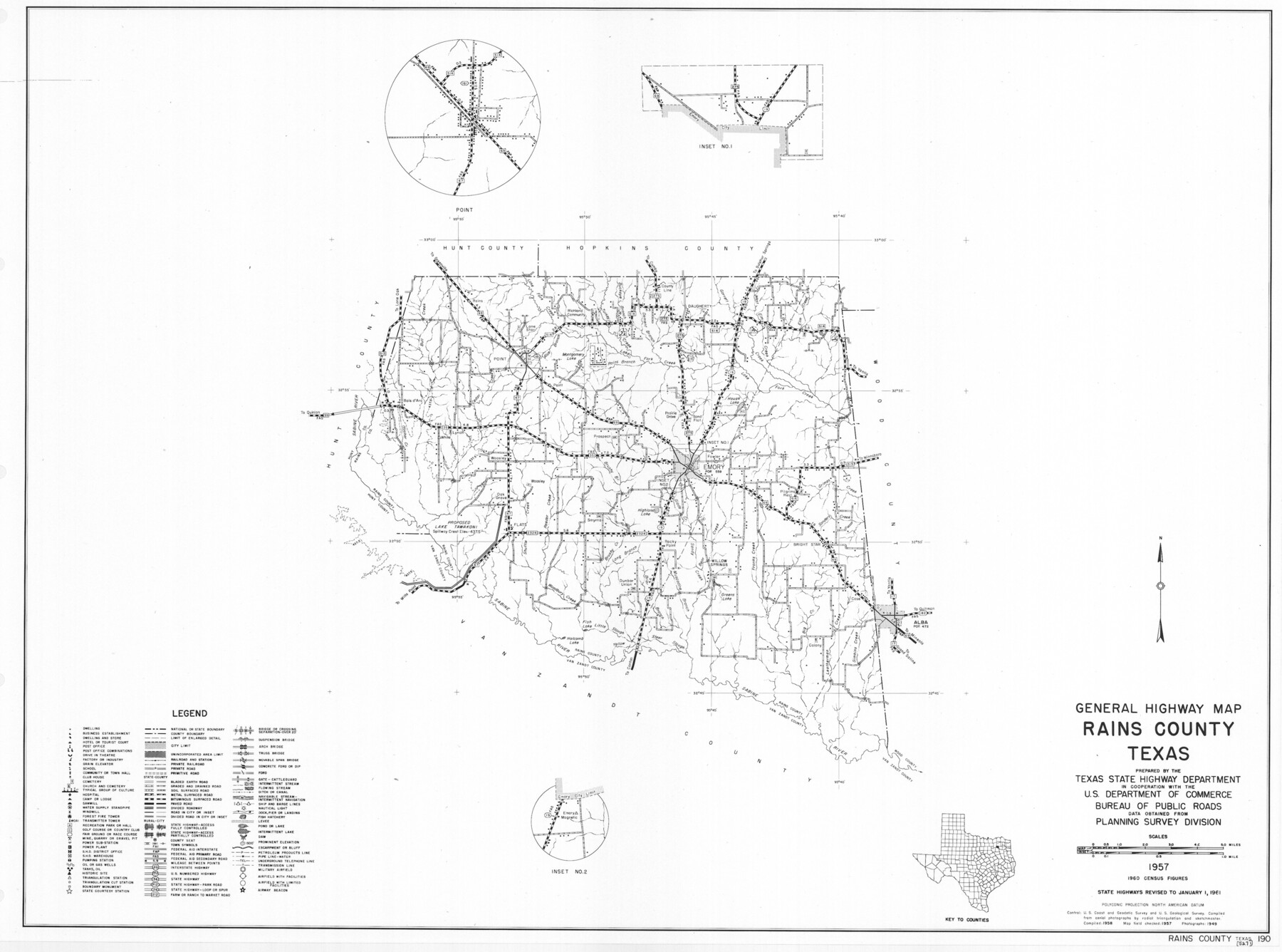
General Highway Map, Rains County, Texas
-
Map/Doc
79634
-
Collection
Texas State Library and Archives
-
Object Dates
1961 (Creation Date)
-
People and Organizations
Texas State Highway Department (Publisher)
-
Counties
Rains
-
Subjects
County
-
Height x Width
18.1 x 24.4 inches
46.0 x 62.0 cm
-
Comments
Prints available courtesy of the Texas State Library and Archives.
More info can be found here: TSLAC Map 05271
Part of: Texas State Library and Archives
Coast Chart No. 106, Galveston Bay to Oyster Bay, Texas

Print $20.00
Coast Chart No. 106, Galveston Bay to Oyster Bay, Texas
1858
Size 32.4 x 40.7 inches
Map/Doc 76252
General Highway Map, La Salle County, Texas

Print $20.00
General Highway Map, La Salle County, Texas
1961
Size 18.2 x 25.0 inches
Map/Doc 79564
General Highway Map, McLennan County, Texas

Print $20.00
General Highway Map, McLennan County, Texas
1961
Size 18.2 x 24.6 inches
Map/Doc 79589
Waco Village, County Seat of McLennan County

Print $20.00
Waco Village, County Seat of McLennan County
1850
Size 15.8 x 12.4 inches
Map/Doc 76268
General Highway Map, Refugio County, Texas

Print $20.00
General Highway Map, Refugio County, Texas
1961
Size 18.1 x 24.7 inches
Map/Doc 79639
General Highway Map. Detail of Cities and Towns in McLennan County, Texas

Print $20.00
General Highway Map. Detail of Cities and Towns in McLennan County, Texas
1961
Size 18.2 x 24.6 inches
Map/Doc 79591
General Highway Map, Brazoria County, Texas

Print $20.00
General Highway Map, Brazoria County, Texas
1961
Size 25.0 x 18.2 inches
Map/Doc 79382
General Highway Map, Lamar County, Texas

Print $20.00
General Highway Map, Lamar County, Texas
1961
Size 24.6 x 18.2 inches
Map/Doc 79561
Town of Lubbock, Texas and Additions

Print $20.00
Town of Lubbock, Texas and Additions
1935
Size 43.8 x 43.5 inches
Map/Doc 76271
General Highway Map, Aransas County, Texas

Print $20.00
General Highway Map, Aransas County, Texas
1961
Size 18.3 x 25.0 inches
Map/Doc 79352
General Highway Map, Stonewall County, Texas

Print $20.00
General Highway Map, Stonewall County, Texas
1961
Size 18.3 x 25.1 inches
Map/Doc 79662
Railroad and County Map of Texas

Print $20.00
Railroad and County Map of Texas
1908
Size 44.5 x 45.8 inches
Map/Doc 76225
You may also like
Bowie County Sketch File 8

Print $42.00
- Digital $50.00
Bowie County Sketch File 8
1927
Size 8.9 x 3.8 inches
Map/Doc 14872
Terry County Sketch File 1

Print $20.00
- Digital $50.00
Terry County Sketch File 1
1903
Size 25.7 x 23.4 inches
Map/Doc 12428
Tom Green County Rolled Sketch 2

Print $20.00
- Digital $50.00
Tom Green County Rolled Sketch 2
Size 17.2 x 26.8 inches
Map/Doc 7992
Pecos County Sketch File 76

Print $4.00
- Digital $50.00
Pecos County Sketch File 76
1943
Size 11.2 x 8.8 inches
Map/Doc 33907
Lipscomb County

Print $20.00
- Digital $50.00
Lipscomb County
1878
Size 18.1 x 16.4 inches
Map/Doc 3816
[Area south of Runnels County School Land]
![93168, [Area south of Runnels County School Land], Twichell Survey Records](https://historictexasmaps.com/wmedia_w700/maps/93168-1.tif.jpg)
Print $40.00
- Digital $50.00
[Area south of Runnels County School Land]
Size 87.7 x 42.9 inches
Map/Doc 93168
Flight Mission No. BRE-2P, Frame 37, Nueces County

Print $20.00
- Digital $50.00
Flight Mission No. BRE-2P, Frame 37, Nueces County
1956
Size 18.4 x 22.4 inches
Map/Doc 86739
The Rand-McNally Official Railway Guide Map of the United States with portions of the Dominion of Canada, the Republic of Mexico, and the West Indies

Print $20.00
- Digital $50.00
The Rand-McNally Official Railway Guide Map of the United States with portions of the Dominion of Canada, the Republic of Mexico, and the West Indies
1927
Size 31.1 x 43.5 inches
Map/Doc 95864
Burnet County Working Sketch Graphic Index

Print $20.00
- Digital $50.00
Burnet County Working Sketch Graphic Index
1924
Size 46.5 x 41.2 inches
Map/Doc 76482
Flight Mission No. CRC-4R, Frame 180, Chambers County

Print $20.00
- Digital $50.00
Flight Mission No. CRC-4R, Frame 180, Chambers County
1956
Size 18.6 x 22.2 inches
Map/Doc 84931
Wise County Sketch File 52

Print $20.00
- Digital $50.00
Wise County Sketch File 52
1982
Size 14.2 x 8.6 inches
Map/Doc 40619
Travis County Working Sketch 32

Print $20.00
- Digital $50.00
Travis County Working Sketch 32
1965
Size 28.0 x 40.0 inches
Map/Doc 69416