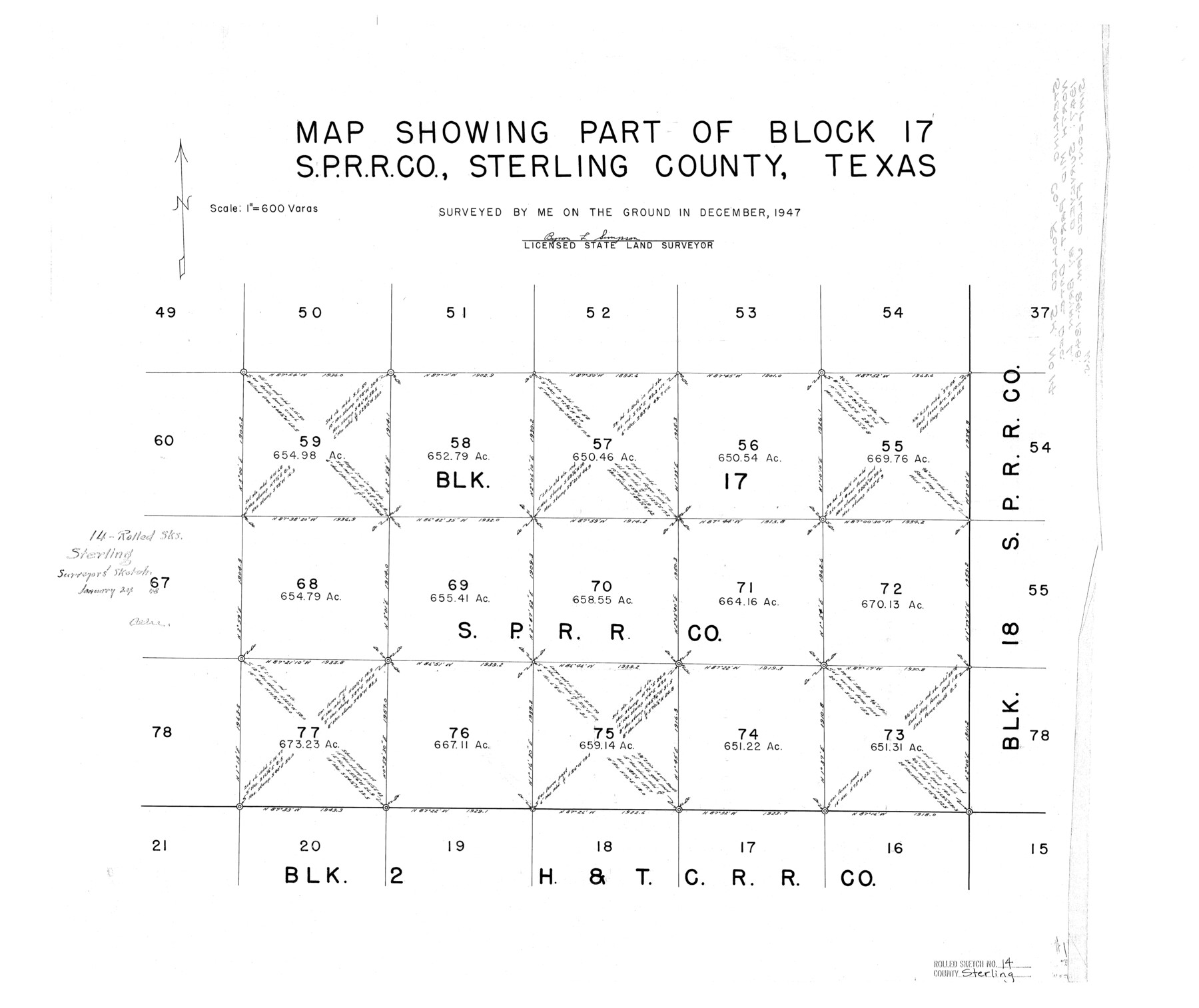
Sterling County Rolled Sketch 14
Map showing part of Block 17, S. P. R.R. Co., Sterling County, Texas
-
Map/Doc
7848
-
Collection
General Map Collection
-
Object Dates
1947 (Survey Date)
1948/1/24 (File Date)
-
People and Organizations
Bryon L. Simpson (Surveyor/Engineer)
-
Counties
Sterling
-
Subjects
Surveying Rolled Sketch
-
Height x Width
22.3 x 26.6 inches
56.6 x 67.6 cm
-
Scale
1" = 600 varas
Part of: General Map Collection
Dimmit County Sketch File 58

Print $20.00
- Digital $50.00
Dimmit County Sketch File 58
1951
Size 18.0 x 9.8 inches
Map/Doc 11361
Texas, Corpus Christi Bay, Mustang Island

Print $40.00
- Digital $50.00
Texas, Corpus Christi Bay, Mustang Island
1940
Size 49.2 x 35.8 inches
Map/Doc 73461
Parker County Sketch File 1

Print $4.00
- Digital $50.00
Parker County Sketch File 1
Size 8.5 x 10.4 inches
Map/Doc 33516
Tom Green County Sketch File 79A

Print $4.00
- Digital $50.00
Tom Green County Sketch File 79A
1970
Size 14.5 x 8.8 inches
Map/Doc 38258

Caldwell County Sketch File 4b

Print $8.00
- Digital $50.00
Caldwell County Sketch File 4b
1896
Size 6.4 x 3.8 inches
Map/Doc 35839
Flight Mission No. DQN-5K, Frame 75, Calhoun County

Print $20.00
- Digital $50.00
Flight Mission No. DQN-5K, Frame 75, Calhoun County
1953
Size 18.4 x 22.1 inches
Map/Doc 84408
Maverick County Rolled Sketch 25

Print $20.00
- Digital $50.00
Maverick County Rolled Sketch 25
1999
Size 24.6 x 24.7 inches
Map/Doc 82574
Bailey County Sketch File 13

Print $40.00
- Digital $50.00
Bailey County Sketch File 13
1912
Size 19.2 x 20.6 inches
Map/Doc 10888
PSL Field Notes for Blocks G, L, P, and Q in Cochran and Yoakum Counties and Blocks U, V, W, Y, and Z in Cochran County

PSL Field Notes for Blocks G, L, P, and Q in Cochran and Yoakum Counties and Blocks U, V, W, Y, and Z in Cochran County
Map/Doc 81645
Presidio County Rolled Sketch 131A

Print $20.00
- Digital $50.00
Presidio County Rolled Sketch 131A
1992
Size 36.5 x 46.7 inches
Map/Doc 9802
Map of Martin County Texas

Print $20.00
- Digital $50.00
Map of Martin County Texas
1880
Size 22.6 x 19.0 inches
Map/Doc 4592
You may also like
Brazoria County Sketch File 33

Print $40.00
- Digital $50.00
Brazoria County Sketch File 33
Size 21.9 x 24.1 inches
Map/Doc 10957
Burnet County Boundary File 9

Print $12.00
- Digital $50.00
Burnet County Boundary File 9
Size 14.1 x 8.6 inches
Map/Doc 50943
Pecos County Sketch File 63

Print $94.00
- Digital $50.00
Pecos County Sketch File 63
1919
Size 8.1 x 13.9 inches
Map/Doc 33792
The Republic County of Jackson. 1840

Print $20.00
The Republic County of Jackson. 1840
2020
Size 15.6 x 21.8 inches
Map/Doc 96186
Kimble County Working Sketch 62

Print $20.00
- Digital $50.00
Kimble County Working Sketch 62
1964
Size 38.0 x 29.7 inches
Map/Doc 70130
Limestone County Rolled Sketch 4

Print $20.00
- Digital $50.00
Limestone County Rolled Sketch 4
1921
Size 35.1 x 35.1 inches
Map/Doc 9573
Robertson County Working Sketch 9

Print $20.00
- Digital $50.00
Robertson County Working Sketch 9
1984
Size 19.9 x 21.5 inches
Map/Doc 63582
Flight Mission No. CUG-3P, Frame 43, Kleberg County

Print $20.00
- Digital $50.00
Flight Mission No. CUG-3P, Frame 43, Kleberg County
1956
Size 18.6 x 22.3 inches
Map/Doc 86248
Lavaca County Working Sketch 22

Print $20.00
- Digital $50.00
Lavaca County Working Sketch 22
1983
Size 39.6 x 36.4 inches
Map/Doc 70375
[Township 3 North, Block 34]
![91208, [Township 3 North, Block 34], Twichell Survey Records](https://historictexasmaps.com/wmedia_w700/maps/91208-1.tif.jpg)
Print $3.00
- Digital $50.00
[Township 3 North, Block 34]
Size 10.2 x 14.0 inches
Map/Doc 91208
Motley County Sketch File 31 (S)

Print $4.00
- Digital $50.00
Motley County Sketch File 31 (S)
1913
Size 14.4 x 6.7 inches
Map/Doc 32213
Map of Dallas & Wichita Railroad Survey

Print $40.00
- Digital $50.00
Map of Dallas & Wichita Railroad Survey
1874
Size 37.3 x 82.7 inches
Map/Doc 64417