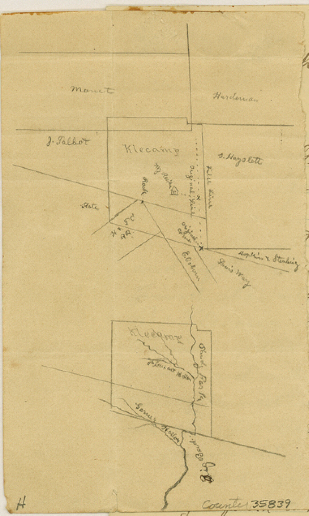
Caldwell County Sketch File 4b
[Sketch and statement regarding Bernard Klecamp survey on old colony line in southeast part of the county]
-
Map/Doc
35839
-
Collection
General Map Collection
-
Object Dates
1896/12/26 (Creation Date)
1896/12/29 (File Date)
-
People and Organizations
G. Hillje (Surveyor/Engineer)
-
Counties
Caldwell
-
Subjects
Surveying Sketch File
-
Height x Width
6.4 x 3.8 inches
16.3 x 9.7 cm
-
Medium
paper, manuscript
-
Features
Sandy Fork
Pleasant Hollow
Part of: General Map Collection
Flight Mission No. DCL-5C, Frame 3, Kenedy County

Print $20.00
- Digital $50.00
Flight Mission No. DCL-5C, Frame 3, Kenedy County
1943
Size 18.4 x 22.2 inches
Map/Doc 85828
Wilbarger County Sketch File 25

Print $6.00
- Digital $50.00
Wilbarger County Sketch File 25
Size 11.0 x 16.7 inches
Map/Doc 40225
Mason County Sketch File 8

Print $4.00
- Digital $50.00
Mason County Sketch File 8
1876
Size 13.2 x 8.4 inches
Map/Doc 30691
Val Verde County Sketch File 44

Print $22.00
- Digital $50.00
Val Verde County Sketch File 44
1940
Size 9.0 x 14.2 inches
Map/Doc 39309
Menard County Rolled Sketch 11

Print $20.00
- Digital $50.00
Menard County Rolled Sketch 11
1962
Size 24.8 x 20.1 inches
Map/Doc 6757
[Surveys in the Bexar District along the Balcones, Cibolo and Leon Creeks]
![63, [Surveys in the Bexar District along the Balcones, Cibolo and Leon Creeks], General Map Collection](https://historictexasmaps.com/wmedia_w700/maps/63.tif.jpg)
Print $3.00
- Digital $50.00
[Surveys in the Bexar District along the Balcones, Cibolo and Leon Creeks]
1842
Size 10.6 x 12.4 inches
Map/Doc 63
Goliad County Sketch File 4

Print $6.00
- Digital $50.00
Goliad County Sketch File 4
1857
Size 7.7 x 12.3 inches
Map/Doc 24216
[Galveston, Harrisburg & San Antonio through El Paso County]
![64005, [Galveston, Harrisburg & San Antonio through El Paso County], General Map Collection](https://historictexasmaps.com/wmedia_w700/maps/64005.tif.jpg)
Print $20.00
- Digital $50.00
[Galveston, Harrisburg & San Antonio through El Paso County]
1906
Size 13.3 x 33.6 inches
Map/Doc 64005
Brown County Working Sketch 5

Print $20.00
- Digital $50.00
Brown County Working Sketch 5
1939
Size 20.9 x 24.0 inches
Map/Doc 67770
Map of Cherokee County

Print $20.00
- Digital $50.00
Map of Cherokee County
1848
Size 27.1 x 20.6 inches
Map/Doc 3390
Montgomery County Working Sketch 43

Print $20.00
- Digital $50.00
Montgomery County Working Sketch 43
1956
Size 29.9 x 25.9 inches
Map/Doc 71150

You may also like
Plan of the City of Austin

Print $40.00
- Digital $50.00
Plan of the City of Austin
1840
Size 57.3 x 42.0 inches
Map/Doc 2179
Val Verde County Working Sketch 40

Print $20.00
- Digital $50.00
Val Verde County Working Sketch 40
1943
Size 31.5 x 29.8 inches
Map/Doc 72175
Presidio County Rolled Sketch 66

Print $20.00
- Digital $50.00
Presidio County Rolled Sketch 66
1920
Size 19.4 x 37.5 inches
Map/Doc 7357
Jefferson County Rolled Sketch 48A

Print $20.00
- Digital $50.00
Jefferson County Rolled Sketch 48A
1964
Size 28.4 x 28.1 inches
Map/Doc 6404
Fort Bend County Rolled Sketch T

Print $20.00
- Digital $50.00
Fort Bend County Rolled Sketch T
1930
Size 28.7 x 25.8 inches
Map/Doc 5908
Aransas County Sketch File 14

Print $36.00
- Digital $50.00
Aransas County Sketch File 14
1891
Size 14.0 x 8.5 inches
Map/Doc 13128
Scurry County Rolled Sketch 9

Print $20.00
- Digital $50.00
Scurry County Rolled Sketch 9
1963
Size 23.0 x 22.0 inches
Map/Doc 7769
Corpus Christi Bay, Texas

Print $40.00
- Digital $50.00
Corpus Christi Bay, Texas
1867
Size 31.9 x 48.8 inches
Map/Doc 73468

Robertson County Sketch File 9

Print $68.00
Robertson County Sketch File 9
1846
Size 10.2 x 8.3 inches
Map/Doc 35366
Working Sketch in Stephens County

Print $2.00
- Digital $50.00
Working Sketch in Stephens County
1919
Size 9.1 x 11.2 inches
Map/Doc 91910
McLennan County Boundary File 6

Print $16.00
- Digital $50.00
McLennan County Boundary File 6
Size 11.1 x 8.6 inches
Map/Doc 56997